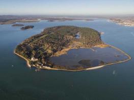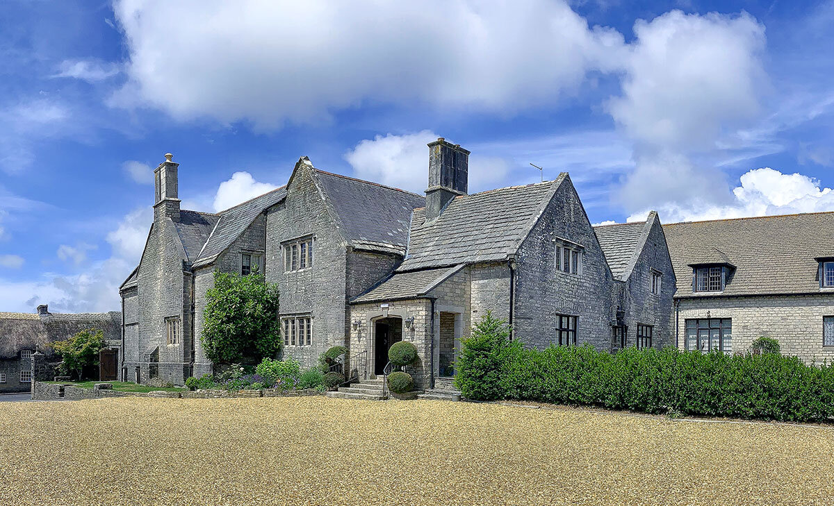


Bradle Farmhouse
Located in the heart of the Purbeck Hills, 2 miles from the Jurassic Coast at Kimmeridge, Bradle…

Kimmeridge
7.5 miles (12.1kms)
There’s a bleakness about Kimmeridge Bay. Giant slabs of black rock shelving out to sea, with crumbling cliffs topped by clumps of wild cabbage, create something of this mood. The slight smell of paraffin from the oil shales and the slow, steady movement of the nodding donkey of the oil well above a little terrace of unmistakably industrial cottages reinforce it.
The story of the bay is intriguing. Iron Age tribes spotted the potential of the band of bituminous shale that runs through Kimmeridge, polishing it up into blackstone arm rings and ornaments, and later into chair and table legs. People have been trying to exploit it ever since. The shale, permeated with crude oil, is also known as Kimmeridge coal, but successive attempts to work it on an industrial scale seemed doomed to failure. These included alum extraction (for dyeing) in the 16th century; use of the coal to fuel a glassworks in the 17th century (it was smelly and inefficient); and use for a variety of chemical distillations, including paraffin wax and varnish, in the 19th century. And, for one brief period, the street lights of Paris were lit by gas extracted from the shale oil. However, nothing lasted very long. Since 1959 BP has drilled down 1,716ft (520m) below the sea, and its beam engine sucks out some 80 barrels (2,800 gallons/12,720 litres) of crude oil a day. Transported to the Wytch Farm collection point (near Corfe Castle), the oil is then pumped to Hamble, to be shipped around the world.
In contrast to Kimmeridge, Tyneham is a cosy farming village clustered around its church in a glorious valley. As you get up close, however, you realise that it’s uncannily neat, like a film set from the 1940s – Greer Garson’s Mrs Miniver could appear at any moment. There’s a spreading oak tree by the church gate; a quaint old phone box; even a village pump. The gravestones all look freshly scrubbed – no lichen here. The farmyard is swept clean and empty. The stone cottages are newly repointed, but roofless. Inside is an exhibition to explain all. The villagers were asked to give up their homes in December 1943 for the ‘war effort’, and Tyneham became absorbed into the vast Lulworth Ranges, as part of the live firing range. It’s a touching memorial, though nothing can make up for the fact that the villagers were never allowed back to their homes.
Turn right up the road and soon left over a stile, signposted ‘Kimmeridge’ – enjoy the sweeping views as you descend. Go through two gates passing the church, then on down the road. After the last house, a path on the right runs alongside the road, then rejoins it before the gate marking where it becomes a private toll road. Follow this on around the hillside and, where it forks, keep ahead, marked ‘Boats and Slipway’. At a stream, your onward route turns right through a car park with toilets but first, you could continue ahead to visit the Wild Seas Centre (open Easter to October).
Cross the foot of a car park with the toilets (signed ‘Range Walks’). Cross the foot of another car park, then descend some steps, cross a bridge and bear right (down left is to the beach). Pass to the left of some cottages and then the oil well. Go through the gate onto the range walk and continue around the coast on a track between yellow posts, crossing two cattle grids. The cliffs of Brandy Bay stagger away to the west.
After a mile (1.6km) cross a stile by a gate and follow the path as it zig-zags sharply uphill. Turn left at the top along a very narrow path to join the coast path at a gate. Continue around the top of Brandy Bay on the cliff path. When you reach a stile and marker stone turn down to the right, signposted ‘Tyneham’. Soon go through a gate to the left and follow the track down into Tyneham village.
After exploring, take the exit road all the way up the hill. At the top, turn right along a path immediately below the road.
Emerge at a gate and turn right down the road, to go past Steeple Pit. Where the road turns sharp left, go straight ahead on the tarmac drive through Steeple Leaze Farm and, heading over a stream, take the stony track ahead, leading straight up the hill under trees. After a gate, keep left up a muddy path that winds through gorse and scrub up the hill. Go through a gateway at the top and continue straight ahead, climbing to a viewpoint over Kimmeridge.
Turn left in front of a gate, and go straight along the edge of the field, following the ridge of the hill, for 0.5 miles (800m), with views to Smedmore House and Corfe Castle. At the road turn right to return to the start.
Grassy tracks and bridle paths, some road walking
Folded hills and valleys around Kimmeridge Bay
Notices request dogs on leads in some sections; some road walking
OS Explorer OL15 Purbeck & South Dorset
Car park in old quarry north of Kimmeridge village
Near Wild Seas Centre at Kimmeridge Bay and Tyneham
Walk goes through Ministry of Defence land, route only walkable when Range Walk is open; see www.dorsetcouncil.gov.uk for further information; keep strictly to paths, between yellow-marked posts, and any MOD signage encountered
Read our tips to look after yourself and the environment when following this walk.
Dorset means rugged varied coastlines and high chalk downlands. Squeezed in among the cliffs and set amid some of Britain’s most beautiful scenery is a chain of picturesque villages and seaside towns. Along the coast you’ll find the Lulworth Ranges, which run from Kimmeridge Bay in the east to Lulworth Cove in the west. Together with a stretch of East Devon, this is Britain’s Jurassic Coast, a UNESCO World Heritage Site and Area of Outstanding Natural Beauty, noted for its layers of shale and numerous fossils embedded in the rock. Among the best-known natural landmarks on this stretch of the Dorset coast is Durdle Door, a rocky arch that has been shaped and sculpted to perfection by the elements. The whole area has the unmistakable stamp of prehistory.
Away from Dorset’s magical coastline lies a landscape with a very different character and atmosphere, but one that is no less appealing. Here, winding, hedge-lined country lanes lead beneath lush, green hilltops to snug, sleepy villages hidden from view and the wider world. The people of Dorset are justifiably proud of the achievements of Thomas Hardy, its most famous son, and much of the county is immortalised in his writing.
Discover more than 15,000 professionally rated places to stay, eat and visit from across the UK and Ireland.
Choose a place to stay safe in the knowledge that it has been expertly assessed by trained assessors.
Search by location or the type of place you're visiting to find your next ideal holiday experience.
Read our articles, city guides and recommended things to do for inspiration. We're here to help you explore the UK.