Glasson and Cockersand

A very easy walk, at its most atmospheric on a blustery day.

NEAREST LOCATION

Glasson

RECOMMENDED BY
DISTANCE

5.5 miles (8.8kms)

ASCENT
131ft (40m)
TIME
1hr 45min
GRADIENT
DIFFICULTY
Easy
STARTING POINT
SD446560

About the walk

Lancaster had been a port since Roman times and during the 18th and early 19th centuries was one of the busiest in the country, handling cargoes of cotton, rum, sugar and tobacco from the West Indies, carried by ships plying the Atlantic 'Slave Triangle'. 

A silting river

However, gradual silting of the River Lune and the increasing tonnage of ships made it harder to reach Lancaster's quays and warehouses. To mitigate the problem, Robert Lawson, a Quaker businessman developed Sunderland Point as a transhipment port, where ships could either wait for a favourable tide or transfer cargoes to smaller craft for transport upriver. But the venture left him bankrupt and the port lost out to Glasson, which was better sited across the mouth of the estuary.

A new dock

Glasson's development began with a pier in 1779, followed by a dock, which was completed in 1787 and could hold 25 ships. However, the problem of getting cargoes upriver to Lancaster still remained.

A canal and railway

The Lancaster Canal was begun in 1793, but it was not until 1825 that the Glasson branch was finished. Opening directly into the sea dock and with wide locks, it enabled smaller seagoing craft to travel directly to Lancaster and Preston. Large cargoes still had to be transferred to barges, but passage along the canal avoided the uncertain battle with tides and river currents. Warehousing, a shipyard and chandlery services sprang up around Glasson's dock and the arrival of the railway in 1883 further improved its prospects.

However, by that time, the Liverpool docks were being expanded and even with the benefits created by Glasson, Lancaster was already declining as a major port. Glasson's railway continued to carry freight until 1968, but passenger services ended in 1930 and the line now serves as a path into the heart of the city. A small amount of cargo still passes through Glasson, but the main business is in recreational craft, catered for in the marina.

The lonely ruin of an abbey

Occupying a low prominence at the edge of the marshes, in what must always have been a quite desolate spot, stand the meagre ruins of Cockersand Abbey. Its origins lie in a small hospital for the charity of pilgrims and the poor, founded in 1184 under the guidance of a hermit, Hugh Garth. It was later encompassed within the Premonstratensian order, initially as a priory and later an abbey. For a while, there were disputes over land ownership with Leicester Abbey, which also had interests here, but all appears to have been resolved by the early 13th century. The community never achieved the wealth enjoyed by some of the northern abbeys, but continued its charitable works until it was dissolved in 1593. All that remains is the octagonal chapter house, which perhaps owes its survival to it being used as a burial place for the Daltons of nearby Thurnham Hall. The rest was demolished, the stones being reused in the surrounding buildings, the sea wall and, reputedly, the quays across the river at Sunderland.

Walk directions

Head left behind the car park past the marina basin, continuing beside the branch canal towards the main line. However, leave at the first bridge onto a lane and follow it right. At a junction, keep ahead along Jeremy Lane.

After some 500yds (457m), just around a sharp left bend, leave over a stile on the right. Follow the field boundary away, swinging left within the corner to another stile. An enclosed grass track leads out to a lane. Go left over a cattle grid towards Kendal Hill Farm. Beyond a bungalow but before reaching the farm, take a stile on the right. Cut left across the field corner to a small gate and walk ahead away by the left boundary. Cross a culvert and continue ahead for the next 0.5 miles (800m), a succession of stiles gates and bridges taking you from field to field towards distant Crook Cottage. Exit the fields beside the cottage onto a lane.

Go left along the seafront to the next house, called Lighthouse Cottage as it reputedly stands on the site of a monastic lighthouse and used to show a light from the corner window to aid navigators. Turn left from the sea and then bear right at a junction. Reaching the second sharp left-hand bend, leave through a kissing gate on the right and follow a track that angles across the fields to Cockersand Abbey Farm. Through a gate, wind right and left past the abandoned farmhouse and continue to the abbey ruins.

Carry on past the Chapter House to join the coast path, passing through a kissing gate to continue along the sea wall past Plover Scar. Emerging by a small parking area, meet the corner of a lane at Lighthouse Cottage. Follow the lane ahead back past Crook Cottage, this time continuing beyond it to the lane's end at Crook Farm.

Turn right in front of the farm, passing through a gate to leave along a grass track. It meanders away across grazing, generally heading towards a distant caravan park. Part-way along pass through a gate to cross a culverted creek, the track curving beyond to join an old hawthorn hedge. Leaving the pastures, continue along a rising hedged track past the caravan park to join its access lane. Walk out to the main lane.

Follow it left to a junction and viewpoint at the top of Tithe Barn Hill. Turn down right through the village, crossing the dock lock bridge back to the car park.

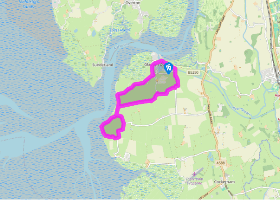
Additional information
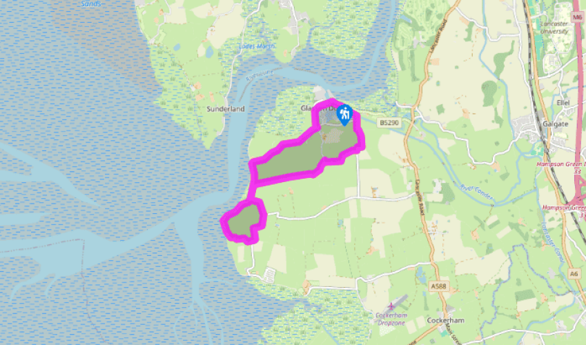
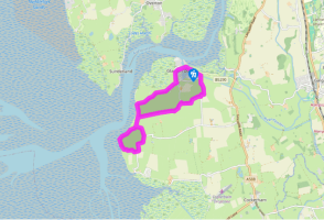
Village streets, tow path, lanes, tracks and sea wall, many stiles

Level fields, a wide estuary and rocky foreshore

Grazing land, dogs need to be under close control

OS Explorer 296 Lancaster, Morecambe & Fleetwood

Car park at East Quay, Glasson

Across road from car park

Been on this walk?

Send us photos or a comment about this route.

Know a good walk?

Share your route with us.

WALKING IN SAFETY

Read our tips to look after yourself and the environment when following this walk.

Find out more

About the area

Discover Lancashire

Lancashire was at the centre of the British cotton industry in the 19th century, which lead to the urbanization of great tracts of the area. The cotton boom came and went, but the industrial profile remains. Lancashire’s resorts, Blackpool, Southport and Morecambe Bay, were originally developed to meet the leisure needs of the cotton mill town workers. Blackpool is the biggest and brashest, celebrated for it tower, miles of promenade, and the coloured light ‘illuminations’. Amusements are taken very seriously here, day and night, and visitors can be entertained in a thousand different ways.

The former county town, Lancaster, boasts one of the younger English universities, dating from 1964. Other towns built up to accommodate the mill-workers with back-to-back terraced houses, are Burnley, Blackburn, Rochdale and Accrington. To get out of town, you can head for the Pennines, the ‘backbone of England’, a series of hills stretching from the Peak District National Park to the Scottish borders. To the north of the country is the Forest of Bowland, which despite its name is fairly open country, high up, with great views.

Why choose Rated Trips?

Your trusted guide to rated places across the UK
icon example
The best coverage

Discover more than 15,000 professionally rated places to stay, eat and visit from across the UK and Ireland.

icon example
Quality assured

Choose a place to stay safe in the knowledge that it has been expertly assessed by trained assessors.

icon example
Plan your next trip

Search by location or the type of place you're visiting to find your next ideal holiday experience.

icon example
Travel inspiration

Read our articles, city guides and recommended things to do for inspiration. We're here to help you explore the UK.