"With the risk of French invasion now passed, you can spy out these Tudor villages and breezy cliffs without fearing arrest."
Walk directions
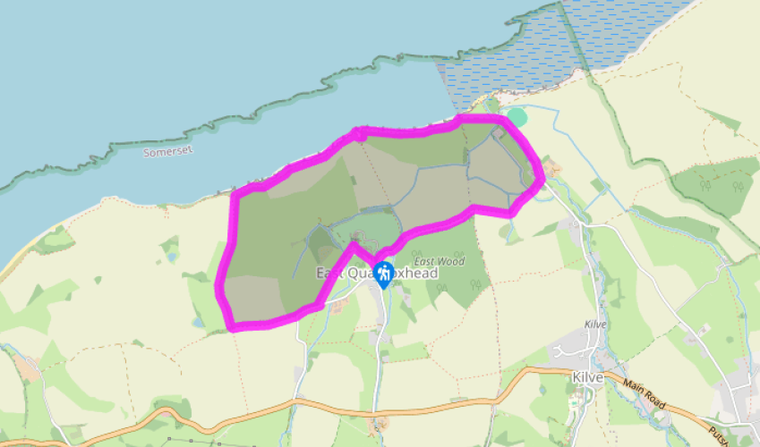
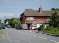
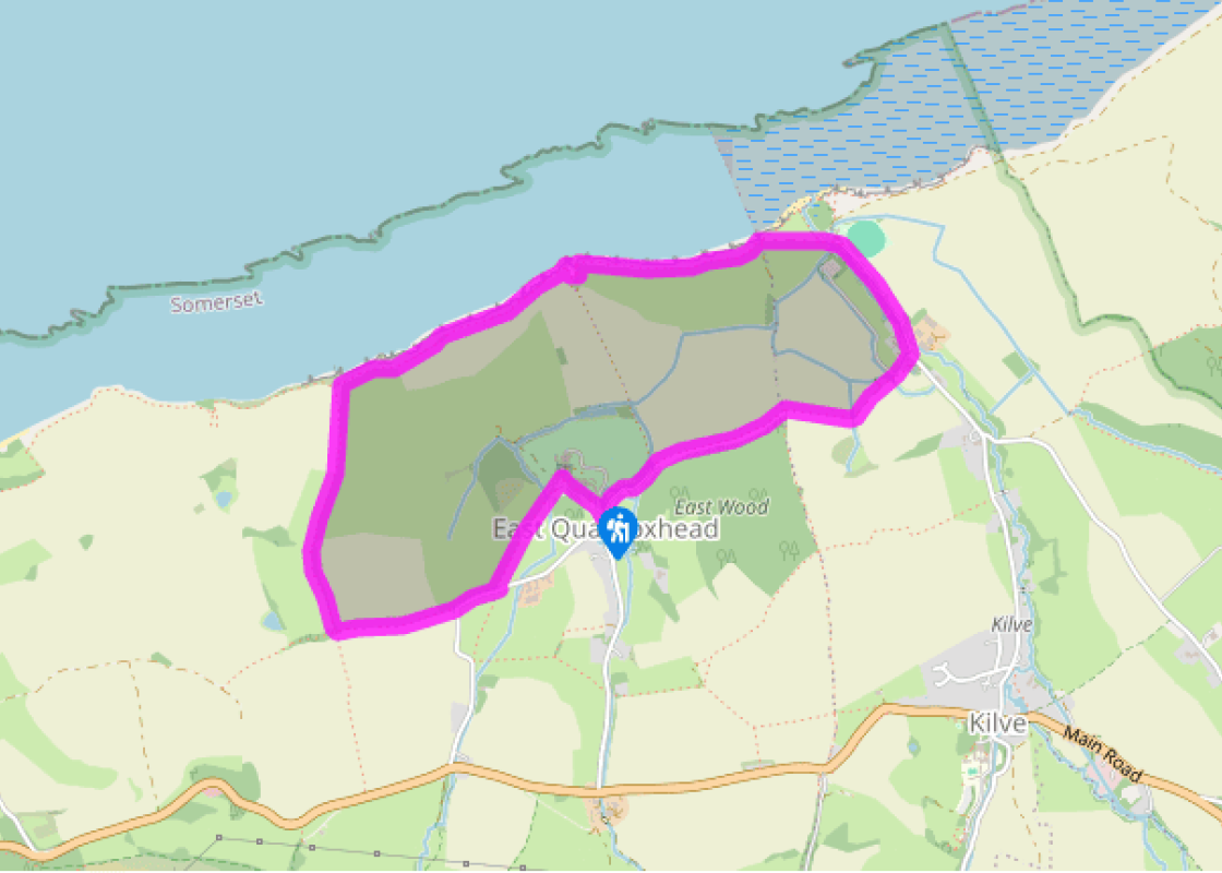
From the car park head back along the lane to the ruined chantry. Turn into the churchyard through a lychgate (signposted). Such gates were built to shelter coffins and their bearers: this one is too small for its purpose, so must be a modern reconstruction. Pass to the left of the church, to reach a kissing gate.
A signposted track crosses a field to a gate; bear right to another gate and pass along the foot of East Wood. (At its far end, a stile allows wandering into the wood, from April to August only.) Ignoring the stile on the left, keep ahead to a field gate and kissing gate. Follow the track as it twice crosses the stream.
The track bends left past gardens and ponds of East Quantoxhead to reach a tarred lane. Turn right, towards the Tudor Court House, but before its gateway bear left into a car park. Pass through to a tarred path and a kissing gate. In an open field this bears right, to St Mary's Church.
Return to the kissing gate but don't go through, instead bear right to a field gate, and cross the field beyond to a distant gate and a lane. Turn right and, where the lane bends left, keep ahead into a green track. At its top, turn right at a 'Permissive path' notice board.
Follow field-edges, with hedges on your right, down to the cliff top, and turn right. A cliff top path leads to a kissing gate before a sharp dip, with a ruined lime kiln opposite. This was built around 1770 to process limestone, which was shipped from Wales, into lime for the fields and for mortar. The foreshore below the kiln is limestone, but it was still easier to bring it by sea across the Bristol Channel.
Turn around the head of the dip, and back left to the cliff top. Here an iron ladder descends to the foreshore: you can see alternating layers of blue-grey lias (a type of limestone) and grey shale. Fossils can be found here, but be aware that the cliffs are unstable - hard hats are now standard wear for geologists. Alternatively, given a suitably trained dog and the right sort of spear, you could pursue the traditional sport of 'glatting' – hunting conger eels in the rock pools. Continue along the wide cliff top path until a tarred path bears off to the right, crossing the stream studied by Coleridge. As you come into the car park, on your left is the brick chimney of a short-lived Oil Retort House (for oil distillation) from 1924; there is oil in the grey shale, but it's probably less trouble to get it from Texas.
With two Tudor villages, industrial remnants dating from only a century ago, and a lucid display of geology underfoot, this is a walk to stimulate the brain as well as the lungs. Jobs for the priests The chantry chapel at Kilve is built in the local grey shale, but with the arches picked out in... orange Quantock sandstone. The sandstone is easier to work into shaped blocks, but has been eroded by the sea winds. This chantry housed five priests whose sole function was the saying of prayers and masses for the deceased Simon de Furneaux and his family. The doctrine was that the rich could pay their way out of purgatory by setting up such chapels. This created employment for priests, but contributed to the general loss of credibility of the Catholic faith. In fact Kilve Chantry closed even before the Reformation, when a Lollard dissenter married into the family in the late 14th century. Later it was used by smugglers for storing brandy and burnt down around 1850 in an alcohol fire. Behind the ruins, the Chantry House has a pigeon loft still in use. The old (possibly Saxon) preaching cross in Quantoxhead churchyard is a viewpoint for the Manor House. It also looks on to the back of Quantoxhead Farm, where the semi-circular wing is a horse-gang. This once housed a capstan where horses walked in circles to power, via an endless belt, farm machinery in the main building. The church itself has fossils incorporated into the walls, and Tudor-carved pew ends. Spies who wrote sonnets When Samual Taylor Coleridge and William Wordsworth walked here, their particular interest was in the Holford stream. Coleridge planned a poem in his deceptively simple 'conversational' style, tracing the stream from its birth high in Hodder Combe. However, the two poets had already aroused local suspicions by their comings and goings, and both had been enthusiastic supporters of the French Revolution in its early days. This was 1797: England was in the grip of invasion fever; and Kilve has a small but usable harbour. Accordingly, a government agent called James Walsh was sent to investigate. He quizzed a footman about their dinnertime conversation: it was reported as being quite impossible to understand, which was, of course, most suspicious. The agent followed them to Kilve. Lurking behind a gorse bush, he heard them discussing 'Spy Nosy' and thought he'd been found out. They had actually been talking about the German philosopher, Spinoza… Coleridge never got round to writing his poem The Brook – but Wordsworth did. Twenty years later, he adopted his friend's plan into a sequence of sonnets on Lakeland's River Duddon.
Somerset remains rural and unspoiled, and ever popular areas to visit are the limestone and red sandstone Mendip Hills rising to over 1,000 feet, and by complete contrast, to the south and southwest, the flat landscape of the Somerset Levels. Another popular spot, the Quantocks, once the haunt of poets Coleridge and Wordsworth, are noted for their gentle slopes, heather-covered moorland expanses and red deer.
"With the risk of French invasion now passed, you can spy out these Tudor villages and breezy cliffs without fearing arrest."
Walk details
1hr 30min
Difficulty:
Easy
Gradient:
Flat
Distance:
3 miles (4.8kms)
Ascent:
250ft (76m)
Walk directions
From the car park head back along the lane to the ruined chantry. Turn into the churchyard through a lychgate (signposted). Such gates were built to shelter coffins and their bearers: this one is too small for its purpose, so must be a modern reconstruction. Pass to the left of the church, to reach a kissing gate.
1 of 6
A signposted track crosses a field to a gate; bear right to another gate and pass along the foot of East Wood. (At its far end, a stile allows wandering into the wood, from April to August only.) Ignoring the stile on the left, keep ahead to a field gate and kissing gate. Follow the track as it twice crosses the stream.
2 of 6
The track bends left past gardens and ponds of East Quantoxhead to reach a tarred lane. Turn right, towards the Tudor Court House, but before its gateway bear left into a car park. Pass through to a tarred path and a kissing gate. In an open field this bears right, to St Mary's Church.
3 of 6
Return to the kissing gate but don't go through, instead bear right to a field gate, and cross the field beyond to a distant gate and a lane. Turn right and, where the lane bends left, keep ahead into a green track. At its top, turn right at a 'Permissive path' notice board.
4 of 6
Follow field-edges, with hedges on your right, down to the cliff top, and turn right. A cliff top path leads to a kissing gate before a sharp dip, with a ruined lime kiln opposite. This was built around 1770 to process limestone, which was shipped from Wales, into lime for the fields and for mortar. The foreshore below the kiln is limestone, but it was still easier to bring it by sea across the Bristol Channel.
5 of 6
Turn around the head of the dip, and back left to the cliff top. Here an iron ladder descends to the foreshore: you can see alternating layers of blue-grey lias (a type of limestone) and grey shale. Fossils can be found here, but be aware that the cliffs are unstable - hard hats are now standard wear for geologists. Alternatively, given a suitably trained dog and the right sort of spear, you could pursue the traditional sport of 'glatting' – hunting conger eels in the rock pools. Continue along the wide cliff top path until a tarred path bears off to the right, crossing the stream studied by Coleridge. As you come into the car park, on your left is the brick chimney of a short-lived Oil Retort House (for oil distillation) from 1924; there is oil in the grey shale, but it's probably less trouble to get it from Texas.
With two Tudor villages, industrial remnants dating from only a century ago, and a lucid display of geology underfoot, this is a walk to stimulate the brain as well as the lungs. Jobs for the priests The chantry chapel at Kilve is built in the local grey shale, but with the arches picked out in... orange Quantock sandstone. The sandstone is easier to work into shaped blocks, but has been eroded by the sea winds. This chantry housed five priests whose sole function was the saying of prayers and masses for the deceased Simon de Furneaux and his family. The doctrine was that the rich could pay their way out of purgatory by setting up such chapels. This created employment for priests, but contributed to the general loss of credibility of the Catholic faith. In fact Kilve Chantry closed even before the Reformation, when a Lollard dissenter married into the family in the late 14th century. Later it was used by smugglers for storing brandy and burnt down around 1850 in an alcohol fire. Behind the ruins, the Chantry House has a pigeon loft still in use. The old (possibly Saxon) preaching cross in Quantoxhead churchyard is a viewpoint for the Manor House. It also looks on to the back of Quantoxhead Farm, where the semi-circular wing is a horse-gang. This once housed a capstan where horses walked in circles to power, via an endless belt, farm machinery in the main building. The church itself has fossils incorporated into the walls, and Tudor-carved pew ends. Spies who wrote sonnets When Samual Taylor Coleridge and William Wordsworth walked here, their particular interest was in the Holford stream. Coleridge planned a poem in his deceptively simple 'conversational' style, tracing the stream from its birth high in Hodder Combe. However, the two poets had already aroused local suspicions by their comings and goings, and both had been enthusiastic supporters of the French Revolution in its early days. This was 1797: England was in the grip of invasion fever; and Kilve has a small but usable harbour. Accordingly, a government agent called James Walsh was sent to investigate. He quizzed a footman about their dinnertime conversation: it was reported as being quite impossible to understand, which was, of course, most suspicious. The agent followed them to Kilve. Lurking behind a gorse bush, he heard them discussing 'Spy Nosy' and thought he'd been found out. They had actually been talking about the German philosopher, Spinoza… Coleridge never got round to writing his poem The Brook – but Wordsworth did. Twenty years later, he adopted his friend's plan into a sequence of sonnets on Lakeland's River Duddon.
Somerset remains rural and unspoiled, and ever popular areas to visit are the limestone and red sandstone Mendip Hills rising to over 1,000 feet, and by complete contrast, to the south and southwest, the flat landscape of the Somerset Levels. Another popular spot, the Quantocks, once the haunt of poets Coleridge and Wordsworth, are noted for their gentle slopes, heather-covered moorland expanses and red deer.