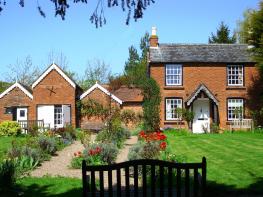


Pool House
Set in the grounds of the main house, this 1930s house has been finished and furnished to an…

Ombersley
5.75 miles (9.2kms)
Ombersley must have been awful before the bypass, but now it verges on the tranquil. Ombersley Court was built in the 1720s. Apparently it has a superb interior, but the nearest you’ll get to even a reasonable view of it is at the far end of the churchyard (beside a grim memorial tree). Sited on the Ombersley Park Estate, St Andrew’s Church was built 100 years after Ombersley Court, but in the decorated style of the early 14th century, presumably to reflect the fragment of the original church (now a mausoleum) behind it.
Along the river towards Holt Fleet Bridge, to your right (and left also) is a classic stretch of woodland, adorning the steep slopes of the great River Severn’s flood plain. If you were to walk along here at dusk you may be fortunate enough to see an owl, possibly even a barn owl. A survey conducted in Worcestershire in 1932 found 184 breeding pairs of barn owls, but a similar survey in 1985 found just 32. There were numerous reasons for its decline. Part of the blame is apportioned to the grubbing out of the hedgerows, thereby removing a good habitat for small mammals, a staple of the barn owls’ diet. However, much of the decline is attributed to intensive agriculture’s use of pesticides. These move along the food chain so that by the time a barn owl has eaten 100 or so slightly contaminated mammals (mice, shrews, voles), the cumulative dosage of pesticide is fatal.
The goal of the Worcestershire Barn Owl Society (WBOS) is to reverse the trend, partly by breeding barn owls and releasing them in carefully chosen locations. The WBOS builds and erects nest boxes in strategic places – you can even buy or sponsor one.
Like other owls, the barn owl flies silently, a useful hunting trick, achieved by having soft tips to its wing feathers – these tips effectively deaden any airflow noise.
The bridge at Holt Fleet replaced a ferry. It was the last in Worcestershire to cease taking tolls. (In Herefordshire tolls are still taken at the 1802 Whitney Bridge, near Clifford.) Such was the belief in a German invasion that mines were laid under the Holt Fleet Bridge during World War II. The Holt Fleet pub was built well before the bridge, and benefited greatly from the daytripper business, being the northern terminus for paddle-steamer trips from Worcester, about 7 miles (11.3km) to the south. These trips ran until the 1930s. In contrast, The Wharf Inn, on the east bank, marks the site of a coal wharf. Holt Lock, a little way upstream, was completed in 1844.
To the south of the village, and beyond the cricket ground, take a path on the right, signposted ‘Turn Mill’. This is the Wychavon Way. Briefly in trees, walk across a meadow to a stile beside a willow. Go along the left-hand field-edges, and briefly by the water’s edge. At the corner of the fish pond, fork right at a waymarker to a track. Turn left past the edge of the pond, following this track right in 80yds (73m), just beyond a gushing stream. After a slight incline in the open, take the left fork where it becomes a sunken path through woodland. Cross a meadow to the river.
Turn right. In 0.75 miles (1.2km) you’ll pass by a caravan site to reach Holt Fleet Bridge. Go under this, continuing for 1 mile (1.6km), passing the staffed Holt Lock. When opposite The Lenchford Inn you’ll come to a riverside gate.
Don’t go through this gate; instead, turn right. In the field corner join the access road. At a junction go straight ahead on the public road by some static caravans. In 650yds (594m), at a right-hand bend, keep this line by moving left, on to a farm track. It’s over 0.25 miles (400m) to the top of this field. Keep on the track, seeing a rusty shack ahead, tucked well into the hedge. When you are 30yds (27m) before it, turn right. Now, in 90yds (82m) go left, over a stile.
What could be mistaken for the fairway of a golf course turns out to be an enormous garden. Aim to pass to the right of the house called Greenfields, and a children’s wooden watchtower, walking beside a walled vegetable garden. Keep ahead to go down its private, brick-paved driveway. Turn right, passing several black-and-white houses, to a T-junction – Uphampton House is in front of you.
Turn left for 110yds (100m), then turn right, uphill. In 150yds (137m), at The Hollies, don’t bend right but go straight ahead, on a shingly track. About 220yds (201m) further, the main track bends right, a rough track goes ahead and a public footpath goes half left.
Take the public footpath option, along a field-edge. Continue through a small area of market garden, reaching a cul-de-sac. Shortly turn right, along the village street. There are many houses to look at, the churches of St Andrew (current and former), and several points of refreshment to delay your return to your car.
Riverside paths, field paths and tracks, village street, several stiles
Estate parkland, riverside meadows and general farmland
Few off-lead opportunities unless very obedient
OS Explorer 204 Worcester & Droitwich Spa
On road parking towards southern end of A4133 (no southbound exit from village)
None on route
Read our tips to look after yourself and the environment when following this walk.
Worcestershire is a county of rolling hills, save for the flat Vale of Evesham in the east and the prominent spine of the Malverns in the west. Nearly all of the land is worked in some way; arable farming predominates – oilseed rape, cereals and potatoes – but there are concentrated areas of specific land uses, such as market gardening and plum growing.
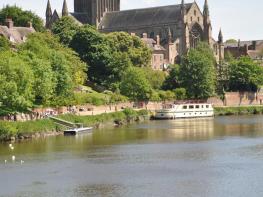
Worcester is the county town, and home to Worcestershire County Cricket Club, which has what some regard as the most attractive grounds in the country, in a delightful setting with views of Worcester Cathedral. The Malverns, Great and Little, set on the slopes of the Malvern Hills, are renowned for their refinement. Great Malvern, terraced on its hillside site, came to prominence as a genteel spa for well-to-do Victorians, rivalling the likes of Bath, Buxton and Cheltenham with its glorious surroundings.
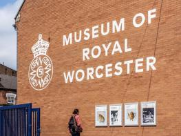
Sir Edward Elgar was a Worcester man, and his statue stands on the High Street, facing the cathedral. The cottage where he was born is now a museum and he is commemorated on the £20 note. Other notable Worcestershire figures include poet A E Housman, chocolate magnate George Cadbury; and Lea and Perrins, inventors of Worcestershire sauce.
Discover more than 15,000 professionally rated places to stay, eat and visit from across the UK and Ireland.
Choose a place to stay safe in the knowledge that it has been expertly assessed by trained assessors.
Search by location or the type of place you're visiting to find your next ideal holiday experience.
Read our articles, city guides and recommended things to do for inspiration. We're here to help you explore the UK.