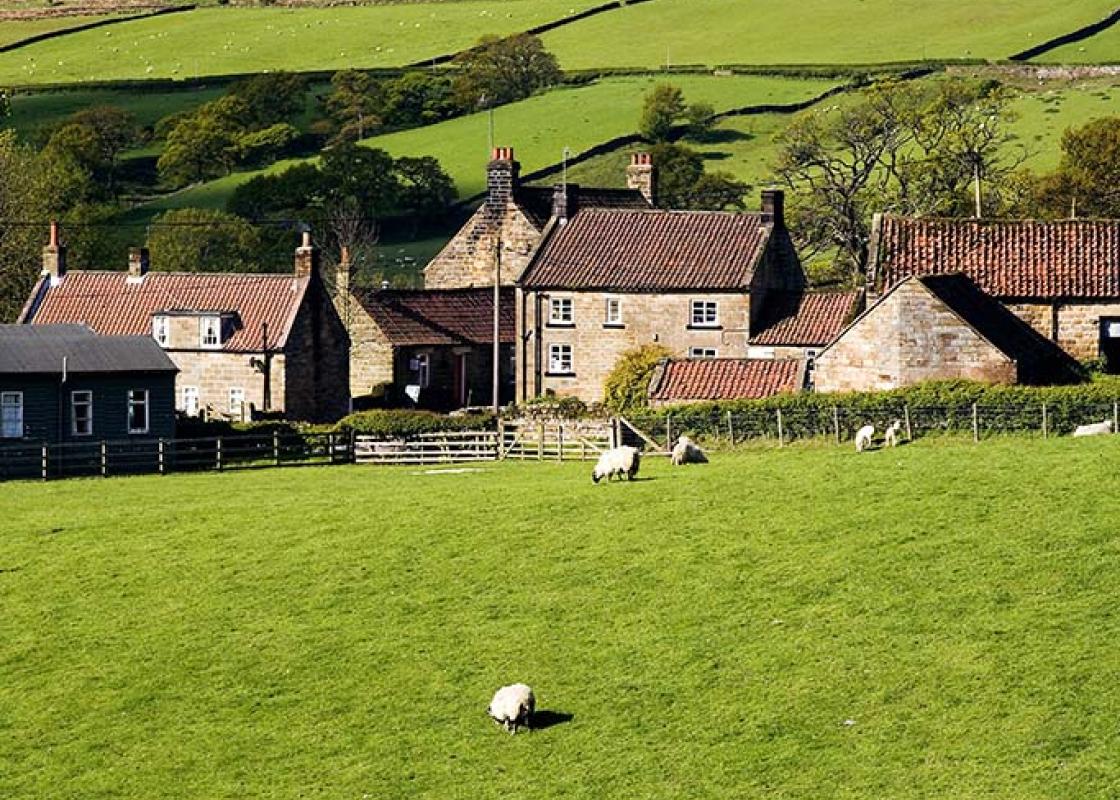
"Historic tracks lead on to wide, open moors and deep, lush woods."
Walk directions
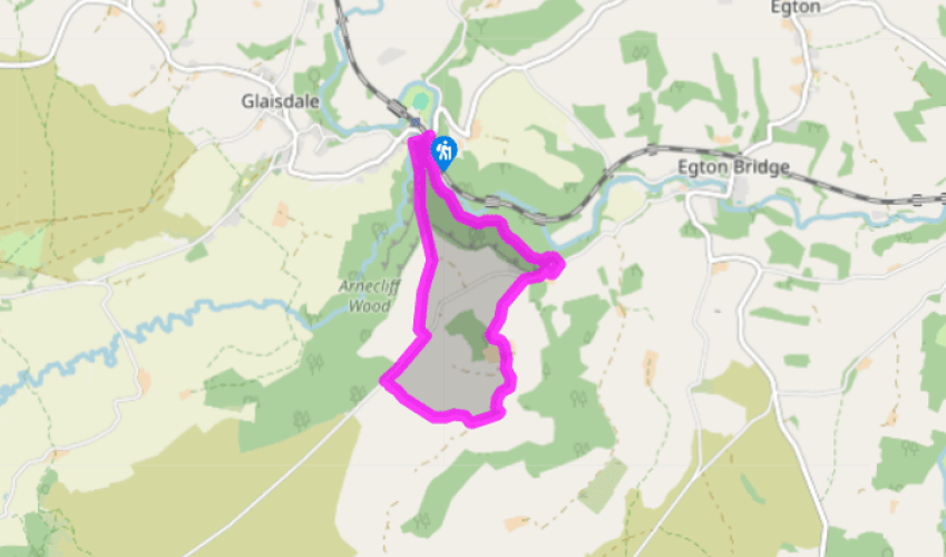
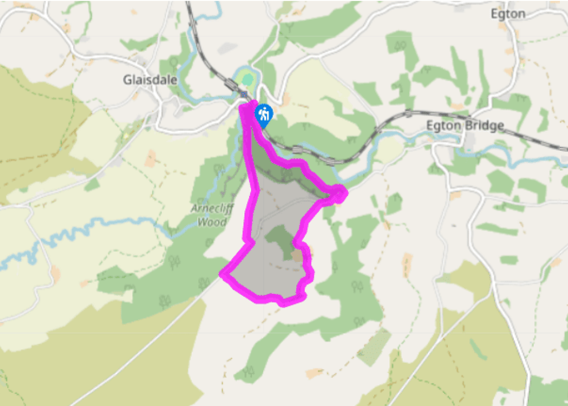
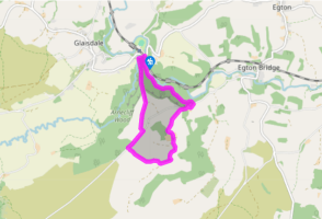
Walk under the railway. Where the road bends right there’s a ford. If dry go across, otherwise use the footbridge. Go ahead up the track. It soon starts to climb steeply, but this eventually eases.
Continue up the rutted track, flanked by well-built walls and trees before open views begin to appear. At Snowdon Nab the track turns to tarmac, though still with a strip of grass down the middle. Keep following it, until it bends left to meet a lane.
Turn right up a steepish climb. After the gradient eases out, look for a footpath sign by a gate on the left. Follow a green path straight ahead down the moor; if the weather’s clear, the Fylingdales ‘pyramid’ on the skyline is a point to aim for. Descend to a gate in the angle of two walls.
Go through and follow the field edge on the left before turning directly downhill, following the groove of an old track. Turn left in a narrow strip of field towards a house (Lodge Hill).
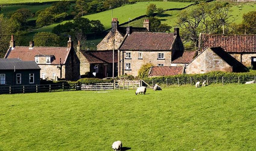
Go through a gate and continue past the house and various crumbling farm buildings, then follow the access track, which bends left and then right. Continue through another farmyard (Butter Park), following the waymark and keep right at a fork to descend to a road opposite a thatched cottage in the hamlet of Delves.
Turn right down the road and descend steeply through some tight bends, with a great view of Eskdale.
Just below the steepest section turn left on a track signed ‘Bridleway Glaisdale’ and follow it through the woods. Eventually it dips to run near the river, then makes a final climb through a gap. Turn right down steps to the footbridge to complete the walk.
There’s a clue before you even start the walk that at least part of it will be on an ancient route. Right by the parking area is a lovely old arched stone bridge over the Esk, known as Beggar’s Bridge. Its low parapets suggest that it was regularly used by laden packhorses. The date 1619 and... initials T F are carved on the east side of the bridge; these are thought to commemorate Alderman Thomas Ferries (or Ferris) of Hull. One version of the story states that as a young man in the neighbourhood he fell in the river and almost drowned while crossing stepping-stones nearby. In thanks for his lucky escape, he vowed that if he ever became wealthy enough he would build a bridge here. An alternative version tells that Ferries fell in love with the daughter of a local squire, and decided to seek his fortune at sea so that he could marry her. On the night before leaving, the river was high and he was unable to pay a last visit to his intended. Again the story tells that he vowed to build a bridge. This version would more clearly explain why the bridge is called Beggar’s Bridge. Both versions agree that Ferries did eventually make a fair fortune at sea, and eventually returned to keep his word (and marry the squire’s daughter). However, it is likely that there was already the remains of a bridge on the spot, and that Ferries actually funded its restoration. Immediately after the start, the walk crosses Glaisdale Beck, just above its confluence with the Esk, and then climbs steadily on to a ridge which later gives views of the dale itself. It’s a short, curving valley notable for its ancient pattern of small, narrow fields. The field pattern looks almost medieval, but Glaisdale village is largely 19th-century. Mining and quarrying have been carried on here for centuries; one legacy of this is the name Delves (Point 6), meaning ‘pits’. The Ordnance Survey map marks ‘iron workings’ near the track early in the walk, and in aerial photographs a large number of pits can be seen, though they are less obvious from ground level. Tracks such as the one through East Arnecliff Wood, used in the final stage of the walk, developed to transport stone, iron ore and agricultural produce. In this steep terrain carts were troublesome, and pack animals – horses and mules – were used instead. Loads would be carried in panniers, with weight equally distributed either side of the animal. Low parapets, like those on Beggar’s Bridge, were equipped to allow clearance for such loads. In East Arnecliff Wood, a continuous single line of stones known as a pannier-way runs along much of the length of the track. Pannier-ways are fairly common in the area, and developed mostly from the late 16th century onward. They were constructed wherever the ground might be soft, to ensure safe passage for strings of packhorses. Mining developed on a larger scale after the opening of the railway (now called the Esk Valley Line) in 1865; this linked at Grosmont with the Whitby–Pickering line. There were mines at Grosmont and Glaisdale, and three blast furnaces were built at Glaisdale by 1869. They failed to compete effectively with larger-scale developments, notably on Teesside, and the works closed within a few years.
North Yorkshire, with its two National Parks and two designated Areas of Outstanding Natural Beauty, is England’s largest county and one of the most rural. This is prime walking country, from the heather-clad heights of the North York Moors to the limestone country that is so typical of the Yorkshire Dales – a place of contrasts and discoveries, of history and legend.
"Historic tracks lead on to wide, open moors and deep, lush woods."
Walk details
1hr 30min
Difficulty:
Hard
Gradient:
Challenging
Distance:
3.5 miles (5.7kms)
Ascent:
720ft (220m)
Walk directions
Walk under the railway. Where the road bends right there’s a ford. If dry go across, otherwise use the footbridge. Go ahead up the track. It soon starts to climb steeply, but this eventually eases.
1 of 7
Continue up the rutted track, flanked by well-built walls and trees before open views begin to appear. At Snowdon Nab the track turns to tarmac, though still with a strip of grass down the middle. Keep following it, until it bends left to meet a lane.
2 of 7
Turn right up a steepish climb. After the gradient eases out, look for a footpath sign by a gate on the left. Follow a green path straight ahead down the moor; if the weather’s clear, the Fylingdales ‘pyramid’ on the skyline is a point to aim for. Descend to a gate in the angle of two walls.
3 of 7
Go through and follow the field edge on the left before turning directly downhill, following the groove of an old track. Turn left in a narrow strip of field towards a house (Lodge Hill).
4 of 7
Go through a gate and continue past the house and various crumbling farm buildings, then follow the access track, which bends left and then right. Continue through another farmyard (Butter Park), following the waymark and keep right at a fork to descend to a road opposite a thatched cottage in the hamlet of Delves.
5 of 7
Turn right down the road and descend steeply through some tight bends, with a great view of Eskdale.
6 of 7
Just below the steepest section turn left on a track signed ‘Bridleway Glaisdale’ and follow it through the woods. Eventually it dips to run near the river, then makes a final climb through a gap. Turn right down steps to the footbridge to complete the walk.
There’s a clue before you even start the walk that at least part of it will be on an ancient route. Right by the parking area is a lovely old arched stone bridge over the Esk, known as Beggar’s Bridge. Its low parapets suggest that it was regularly used by laden packhorses. The date 1619 and... initials T F are carved on the east side of the bridge; these are thought to commemorate Alderman Thomas Ferries (or Ferris) of Hull. One version of the story states that as a young man in the neighbourhood he fell in the river and almost drowned while crossing stepping-stones nearby. In thanks for his lucky escape, he vowed that if he ever became wealthy enough he would build a bridge here. An alternative version tells that Ferries fell in love with the daughter of a local squire, and decided to seek his fortune at sea so that he could marry her. On the night before leaving, the river was high and he was unable to pay a last visit to his intended. Again the story tells that he vowed to build a bridge. This version would more clearly explain why the bridge is called Beggar’s Bridge. Both versions agree that Ferries did eventually make a fair fortune at sea, and eventually returned to keep his word (and marry the squire’s daughter). However, it is likely that there was already the remains of a bridge on the spot, and that Ferries actually funded its restoration. Immediately after the start, the walk crosses Glaisdale Beck, just above its confluence with the Esk, and then climbs steadily on to a ridge which later gives views of the dale itself. It’s a short, curving valley notable for its ancient pattern of small, narrow fields. The field pattern looks almost medieval, but Glaisdale village is largely 19th-century. Mining and quarrying have been carried on here for centuries; one legacy of this is the name Delves (Point 6), meaning ‘pits’. The Ordnance Survey map marks ‘iron workings’ near the track early in the walk, and in aerial photographs a large number of pits can be seen, though they are less obvious from ground level. Tracks such as the one through East Arnecliff Wood, used in the final stage of the walk, developed to transport stone, iron ore and agricultural produce. In this steep terrain carts were troublesome, and pack animals – horses and mules – were used instead. Loads would be carried in panniers, with weight equally distributed either side of the animal. Low parapets, like those on Beggar’s Bridge, were equipped to allow clearance for such loads. In East Arnecliff Wood, a continuous single line of stones known as a pannier-way runs along much of the length of the track. Pannier-ways are fairly common in the area, and developed mostly from the late 16th century onward. They were constructed wherever the ground might be soft, to ensure safe passage for strings of packhorses. Mining developed on a larger scale after the opening of the railway (now called the Esk Valley Line) in 1865; this linked at Grosmont with the Whitby–Pickering line. There were mines at Grosmont and Glaisdale, and three blast furnaces were built at Glaisdale by 1869. They failed to compete effectively with larger-scale developments, notably on Teesside, and the works closed within a few years.
North Yorkshire, with its two National Parks and two designated Areas of Outstanding Natural Beauty, is England’s largest county and one of the most rural. This is prime walking country, from the heather-clad heights of the North York Moors to the limestone country that is so typical of the Yorkshire Dales – a place of contrasts and discoveries, of history and legend.