"Take the connoisseur's way to the highest ground in southern Britain."
Walk directions
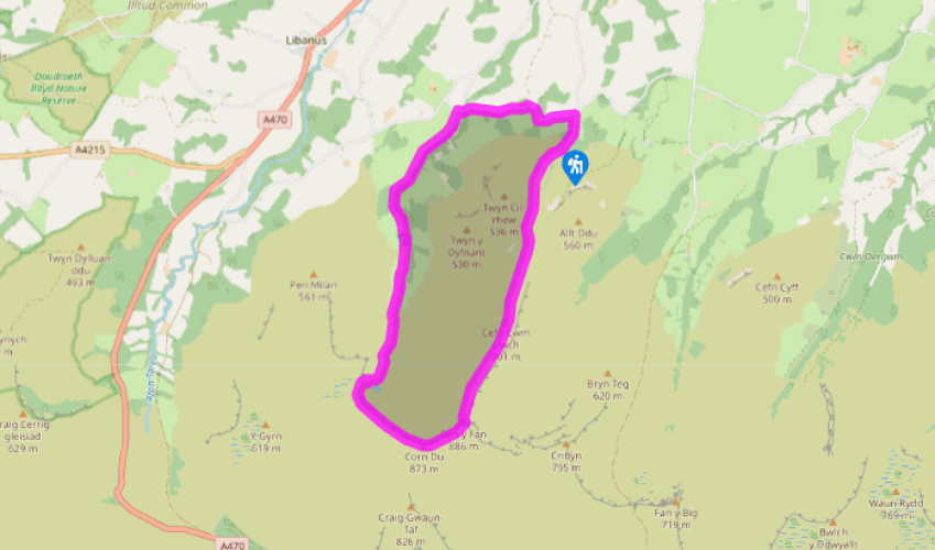
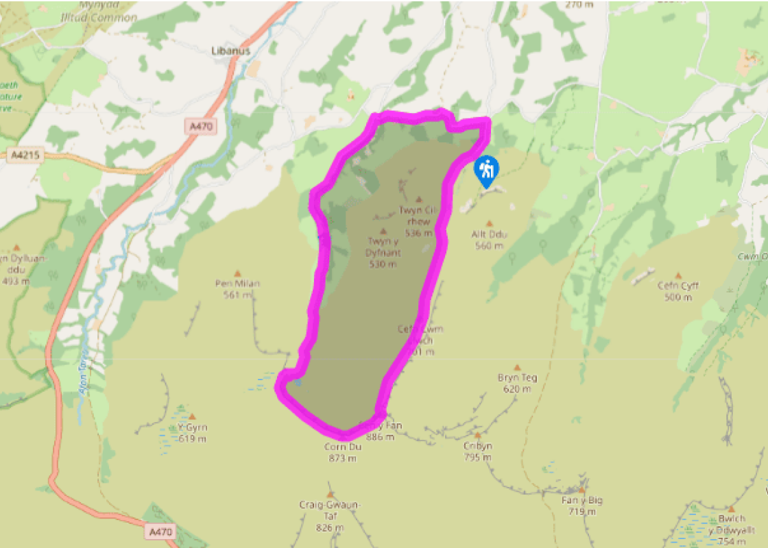
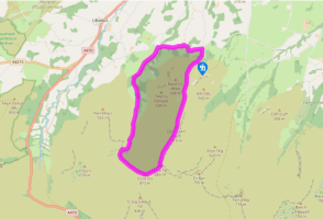
There’s a bridge and a small picnic area at the southern end of the lay-by. Go through the kissing gate on the other side of the bridge to the picnic area. Head towards the crags, following a clear footpath, until you come to a gap in the next wall.
Pass through this and turn right to follow a dry-stone wall north. Head down into a small valley and cross the stream to continue in the same direction. Drop into another, steeper, valley and climb out, still following the track. Continue through the bracken to a kissing gate.
Cross and turn left on to a stony track. Follow this up to a gate and a stile and continue through rough ground, churned up by mining, until it levels on a dished plateau. Bear right here to the whitewashed trig point of Fan Frynych, then turn sharp left to return to the main track above the escarpment.
Turn right on to the main track again and continue past more rough ground before dropping slightly into a broad but shallow valley. Near the bottom, go through a kissing gate on the left (signed ‘Beacons Way’).
Follow the obvious path straight ahead and cross the top of the steep hillside to a beautifully built cone-shaped cairn. Turn right here to drop steeply all the way down into the heart of the nature reserve, following regular waymarker posts.
As the ground levels, bear around to the right to follow a signed diversion and continue alongside the stream to the gap in the wall you passed through earlier. Go through again and follow the outward path back to the car park.
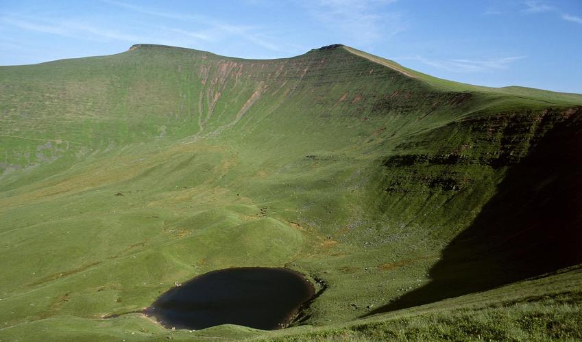
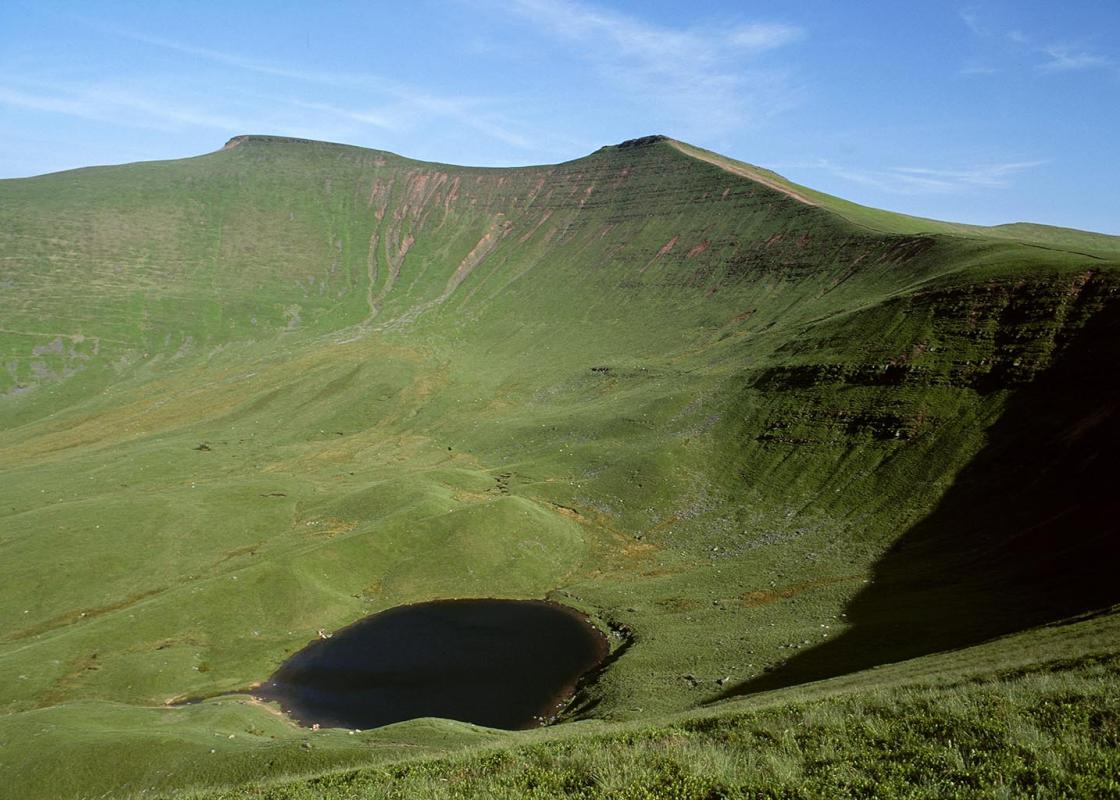
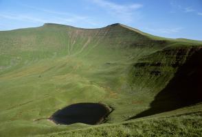
This is a short walk but it has much to offer. Firstly, there are some fine views over the Tarell Valley to the true kings of the National Park, Pen y Fan and Corn Du, whose lofty crowns command your attention for most of the way round. And secondly, the daunting crags of Craig Cerrig-gleisiad are... a true spectacle in their own right and are well worth admiring close up, both from below and above. This is a unique environment and, as such, it hosts a range of habitats that support a number of rare species of flora and fauna. The cirque (bowl-shaped basin) itself was formed by the action of an ice-age glacier, which scoured out a deep hollow in the hillside and then deposited the rocks it had accumulated at the foot of the cliff to form banks of moraine. The retreating ice left a legacy – a selection of arctic-alpine plants that were sheltered from the rising temperatures by the north-facing escarpment. These plants, which include saxifrages and roseroot, also need a lime-rich soil, present on the escarpments but not on the more acidic moorland on the tops. The cliffs only make up a fraction of the 156-acre (63ha) National Nature Reserve. One of the things that makes Craig Cerrig-gleisiad – which means ‘Blue-stone Rock’ – special is the diversity of the terrain. The lower slopes are home to mixed woodland and flowers such as orchids and anemones, while the high ground supports heather and bilberry. You’ll see plenty of sheep within the reserve, but grazing is controlled to ensure a variety of habitats. The diversity isn’t just restricted to plants either – 16 species of butterfly have been recorded on the reserve and over 80 different types of birds, including the ring ouzel, or mountain blackbird as it’s often known, and the peregrine falcon, which is definitely a bird of the cliffs. This mainly upland region of the Bannau Brycheiniog (Brecon Beacons) National Park is partitioned from the central Brecon Beacons by the deep slash of the Taf and Tarell valleys. The name Fforest Fawr, which means Great Forest, comes not from trees but from its one-time status as a royal hunting ground. The high ground is largely untracked and barren, but the north-facing escarpment, of which Craig Cerriggleisiad forms a part, is steep and impressive. As the land dips to the south, it is chiselled into a succession of north–south running valleys that cradle the infant forms of some of the National Park’s greatest rivers. These are seen to best effect on the southern fringes of the park, where they form Fforest Fawr’s greatest spectacle, Waterfall Country.
The largest unitary authority in Wales, Powys covers an area of approximately 2,000 square miles. Much of that is mountainous because it actually has the lowest population density of all the Welsh counties.
"Take the connoisseur's way to the highest ground in southern Britain."
Walk details
2hrs
Difficulty:
Hard
Gradient:
Challenging
Distance:
4 miles (6.4kms)
Ascent:
1050ft (320m)
Walk directions
There’s a bridge and a small picnic area at the southern end of the lay-by. Go through the kissing gate on the other side of the bridge to the picnic area. Head towards the crags, following a clear footpath, until you come to a gap in the next wall.
1 of 6
Pass through this and turn right to follow a dry-stone wall north. Head down into a small valley and cross the stream to continue in the same direction. Drop into another, steeper, valley and climb out, still following the track. Continue through the bracken to a kissing gate.
2 of 6
Cross and turn left on to a stony track. Follow this up to a gate and a stile and continue through rough ground, churned up by mining, until it levels on a dished plateau. Bear right here to the whitewashed trig point of Fan Frynych, then turn sharp left to return to the main track above the escarpment.
3 of 6
Turn right on to the main track again and continue past more rough ground before dropping slightly into a broad but shallow valley. Near the bottom, go through a kissing gate on the left (signed ‘Beacons Way’).
4 of 6
Follow the obvious path straight ahead and cross the top of the steep hillside to a beautifully built cone-shaped cairn. Turn right here to drop steeply all the way down into the heart of the nature reserve, following regular waymarker posts.
5 of 6
As the ground levels, bear around to the right to follow a signed diversion and continue alongside the stream to the gap in the wall you passed through earlier. Go through again and follow the outward path back to the car park.
This is a short walk but it has much to offer. Firstly, there are some fine views over the Tarell Valley to the true kings of the National Park, Pen y Fan and Corn Du, whose lofty crowns command your attention for most of the way round. And secondly, the daunting crags of Craig Cerrig-gleisiad are... a true spectacle in their own right and are well worth admiring close up, both from below and above. This is a unique environment and, as such, it hosts a range of habitats that support a number of rare species of flora and fauna. The cirque (bowl-shaped basin) itself was formed by the action of an ice-age glacier, which scoured out a deep hollow in the hillside and then deposited the rocks it had accumulated at the foot of the cliff to form banks of moraine. The retreating ice left a legacy – a selection of arctic-alpine plants that were sheltered from the rising temperatures by the north-facing escarpment. These plants, which include saxifrages and roseroot, also need a lime-rich soil, present on the escarpments but not on the more acidic moorland on the tops. The cliffs only make up a fraction of the 156-acre (63ha) National Nature Reserve. One of the things that makes Craig Cerrig-gleisiad – which means ‘Blue-stone Rock’ – special is the diversity of the terrain. The lower slopes are home to mixed woodland and flowers such as orchids and anemones, while the high ground supports heather and bilberry. You’ll see plenty of sheep within the reserve, but grazing is controlled to ensure a variety of habitats. The diversity isn’t just restricted to plants either – 16 species of butterfly have been recorded on the reserve and over 80 different types of birds, including the ring ouzel, or mountain blackbird as it’s often known, and the peregrine falcon, which is definitely a bird of the cliffs. This mainly upland region of the Bannau Brycheiniog (Brecon Beacons) National Park is partitioned from the central Brecon Beacons by the deep slash of the Taf and Tarell valleys. The name Fforest Fawr, which means Great Forest, comes not from trees but from its one-time status as a royal hunting ground. The high ground is largely untracked and barren, but the north-facing escarpment, of which Craig Cerriggleisiad forms a part, is steep and impressive. As the land dips to the south, it is chiselled into a succession of north–south running valleys that cradle the infant forms of some of the National Park’s greatest rivers. These are seen to best effect on the southern fringes of the park, where they form Fforest Fawr’s greatest spectacle, Waterfall Country.
The largest unitary authority in Wales, Powys covers an area of approximately 2,000 square miles. Much of that is mountainous because it actually has the lowest population density of all the Welsh counties.