"Along the shores of Ramsey Sound with great views and excellent wildlife-spotting opportunities."
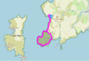
Walk directions
Walk down to the lifeboat station and turn left on to the coast path, above the steps. Follow this, passing above a number of lofty, grassy promontories that make great picnic spots. After 0.5 miles (800m), look out for the traces of Iron Age earthworks on the left.
Pass a gate and a track on your left – this will be your return route – and swing around to the west above Ogof Felen. This is a good seal pup beach in autumn. The trail climbs slightly and then drops steeply to a ruined copper mine, directly opposite The Bitches.
Continue easily to Pen Dal-Aderyn and then swing eastwards to enter St Brides Bay. The path climbs above some magnificent cliffs and passes between a few rocky outcrops before veering north above the broad bay of Porth Henllys. Drop down into a shallow valley until you come to a fingerpost at a junction of paths
Follow the coast path and then climb up out of the dip. This leads around Maen Llwydwyn and down to Porthlysgi Bay. This was the site of the original St Davids lifeboat station, replaced by the one at St Justinian’s. Cross a stream as it runs down the beach and turn left to climb back up, behind the beach, and on to the cliff tops near the rocky island of Carreg Fran.
The gradient eases again and the path now cruises comfortably along a wonderful section of coast, studded with rock arches and caves. At Llech Cyllyll, turn back inland to drop down into the deeply cloven inlet of Porth Clais. The harbour was built in the 12th century and was once the main port for St Davids, used for importing coal and timber among other things. The main car park is on the site of the now defunct St Davids gasworks. These in turn had been built over the site of a spring, said to be the place that St David was baptised. Porth Clais is also purported to be the landing place of the legendary magic boar, Twrch Trywyth, after he swam from Ireland to confront King Arthur. Turn left on to the road and climb steeply past the car park. Continue easily to a crossroads.
Keep straight ahead to pass Clegyr-Boia and the small lake of Pwll Trefeiddan, a popular stop-over for migrating waterfowl. Turn left at the T-junction and follow the road back to St Justinian’s, ignoring the turning to the right.
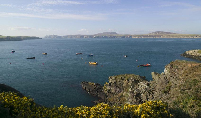
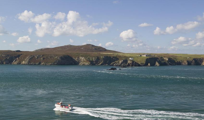
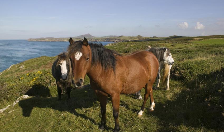
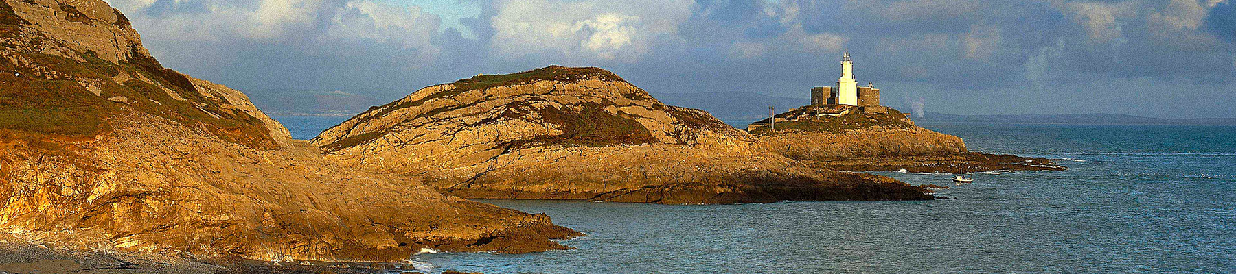
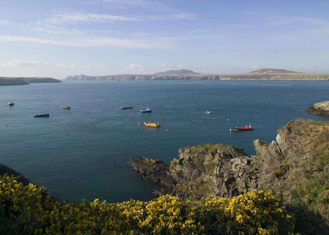
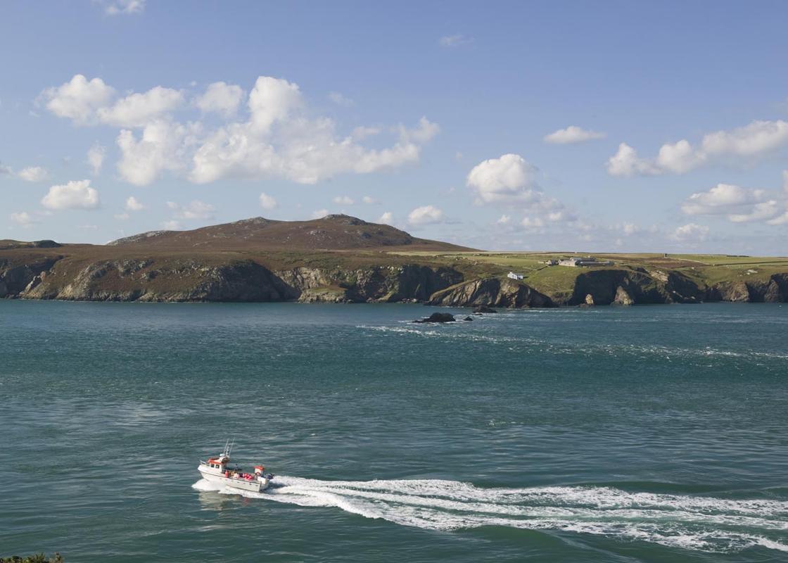
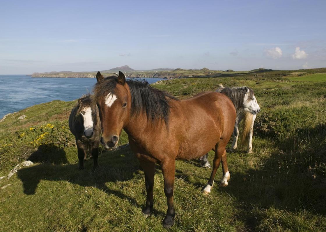
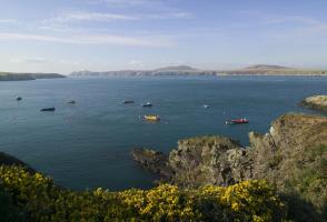
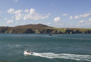
This is one of the most rewarding walks, with drop-dead gorgeous coastal scenery and plenty of chances to spot some of Pembrokeshire’s varied wildlife. On a calm summer’s day, the bobbing boats in Ramsey Sound display the kind of tranquillity you’d usually associate with a Greek island. See it on... a rough day, with a spring tide running, and the frothing, seething currents that whip through the narrow channel and it’s the opposite. If the views aren’t enough, a keen eye and a handy pair of binoculars may well produce sightings of seals, porpoises, dolphins, choughs and even peregrine falcons. St Justinian was a hermit from Brittany who became the abbot of St Davids Cathedral and acted as St David’s confessor. Disillusioned with the lethargic attitude of the monks, he absconded to Ramsey Island to establish a more spiritual community. Some of his more loyal monks travelled with him, but eventually even they became fed up with his strict regimes and chopped off his head. It is said he walked back across Ramsey Sound carrying it in his arms. His remains were buried in the small chapel on the hillside overlooking the sound, which bears his name. Later, St David took them to his own church. St Justinian is revered as a martyr, his assassins are thought to have been under demonic influence, and his life is celebrated on 5 December each year. Less than 2 miles (3.2km) long and 446ft (136m) high at its tallest point, Ramsey Island is a lumbering humpback ridge separated from the St Davids coast by a narrow sound. Known in Welsh as Ynys Ddewi – St Davids Isle – this is the place where, legend suggests, St David met St Patrick. It’s a haven for wildlife and has belonged to the RSPB as a nature reserve since 1992. The eastern coast looks pretty tame, but the western seaboard boasts some of Pembrokeshire’s tallest and most impressive cliffs, punctuated with sea caves and rock arches that are the breeding grounds of the area’s largest seal colony. At its narrowest point, a string of jagged rocks protrude into the sound, known as The Bitches. Tides gush through the rocks at speeds of up to 8 knots, creating a scene that resembles a mountain river in spate. The resultant waves and eddies make an extreme salt-water playground for whitewater kayakers. The island is also populated by a herd of red deer. Ramsey Sound is one the best places to catch a glimpse of harbour porpoises. Resembling dolphins, though never more than 7ft (2.1m) in length, small schools crop up all around the coast, but are frequently seen feeding in the currents at either end of the sound. Unlike dolphins, they seldom leap from the water, but their arched backs and small dorsal fins are easy to spot as they surface for air. Choose a day when the water is fairly flat, then scan the ocean from a promontory like Pen Dal-Aderyn with a pair of binoculars.
Wales meets the Atlantic Ocean in spectacular fashion at Pembrokeshire. Unlike the West Country, Pembrokeshire can offer the coast without the crowds, and quaint fishing villages without those huge coach parks.
"Along the shores of Ramsey Sound with great views and excellent wildlife-spotting opportunities."
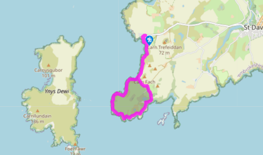
Walk details
3hrs
Difficulty:
Easy
Gradient:
Moderate
Distance:
6 miles (9.7kms)
Ascent:
755ft (230m)
Walk directions
Walk down to the lifeboat station and turn left on to the coast path, above the steps. Follow this, passing above a number of lofty, grassy promontories that make great picnic spots. After 0.5 miles (800m), look out for the traces of Iron Age earthworks on the left.
1 of 6
Pass a gate and a track on your left – this will be your return route – and swing around to the west above Ogof Felen. This is a good seal pup beach in autumn. The trail climbs slightly and then drops steeply to a ruined copper mine, directly opposite The Bitches.
2 of 6
Continue easily to Pen Dal-Aderyn and then swing eastwards to enter St Brides Bay. The path climbs above some magnificent cliffs and passes between a few rocky outcrops before veering north above the broad bay of Porth Henllys. Drop down into a shallow valley until you come to a fingerpost at a junction of paths
3 of 6
Follow the coast path and then climb up out of the dip. This leads around Maen Llwydwyn and down to Porthlysgi Bay. This was the site of the original St Davids lifeboat station, replaced by the one at St Justinian’s. Cross a stream as it runs down the beach and turn left to climb back up, behind the beach, and on to the cliff tops near the rocky island of Carreg Fran.
4 of 6
The gradient eases again and the path now cruises comfortably along a wonderful section of coast, studded with rock arches and caves. At Llech Cyllyll, turn back inland to drop down into the deeply cloven inlet of Porth Clais. The harbour was built in the 12th century and was once the main port for St Davids, used for importing coal and timber among other things. The main car park is on the site of the now defunct St Davids gasworks. These in turn had been built over the site of a spring, said to be the place that St David was baptised. Porth Clais is also purported to be the landing place of the legendary magic boar, Twrch Trywyth, after he swam from Ireland to confront King Arthur. Turn left on to the road and climb steeply past the car park. Continue easily to a crossroads.
5 of 6
Keep straight ahead to pass Clegyr-Boia and the small lake of Pwll Trefeiddan, a popular stop-over for migrating waterfowl. Turn left at the T-junction and follow the road back to St Justinian’s, ignoring the turning to the right.
This is one of the most rewarding walks, with drop-dead gorgeous coastal scenery and plenty of chances to spot some of Pembrokeshire’s varied wildlife. On a calm summer’s day, the bobbing boats in Ramsey Sound display the kind of tranquillity you’d usually associate with a Greek island. See it on... a rough day, with a spring tide running, and the frothing, seething currents that whip through the narrow channel and it’s the opposite. If the views aren’t enough, a keen eye and a handy pair of binoculars may well produce sightings of seals, porpoises, dolphins, choughs and even peregrine falcons. St Justinian was a hermit from Brittany who became the abbot of St Davids Cathedral and acted as St David’s confessor. Disillusioned with the lethargic attitude of the monks, he absconded to Ramsey Island to establish a more spiritual community. Some of his more loyal monks travelled with him, but eventually even they became fed up with his strict regimes and chopped off his head. It is said he walked back across Ramsey Sound carrying it in his arms. His remains were buried in the small chapel on the hillside overlooking the sound, which bears his name. Later, St David took them to his own church. St Justinian is revered as a martyr, his assassins are thought to have been under demonic influence, and his life is celebrated on 5 December each year. Less than 2 miles (3.2km) long and 446ft (136m) high at its tallest point, Ramsey Island is a lumbering humpback ridge separated from the St Davids coast by a narrow sound. Known in Welsh as Ynys Ddewi – St Davids Isle – this is the place where, legend suggests, St David met St Patrick. It’s a haven for wildlife and has belonged to the RSPB as a nature reserve since 1992. The eastern coast looks pretty tame, but the western seaboard boasts some of Pembrokeshire’s tallest and most impressive cliffs, punctuated with sea caves and rock arches that are the breeding grounds of the area’s largest seal colony. At its narrowest point, a string of jagged rocks protrude into the sound, known as The Bitches. Tides gush through the rocks at speeds of up to 8 knots, creating a scene that resembles a mountain river in spate. The resultant waves and eddies make an extreme salt-water playground for whitewater kayakers. The island is also populated by a herd of red deer. Ramsey Sound is one the best places to catch a glimpse of harbour porpoises. Resembling dolphins, though never more than 7ft (2.1m) in length, small schools crop up all around the coast, but are frequently seen feeding in the currents at either end of the sound. Unlike dolphins, they seldom leap from the water, but their arched backs and small dorsal fins are easy to spot as they surface for air. Choose a day when the water is fairly flat, then scan the ocean from a promontory like Pen Dal-Aderyn with a pair of binoculars.
Wales meets the Atlantic Ocean in spectacular fashion at Pembrokeshire. Unlike the West Country, Pembrokeshire can offer the coast without the crowds, and quaint fishing villages without those huge coach parks.