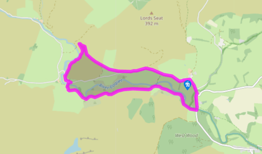
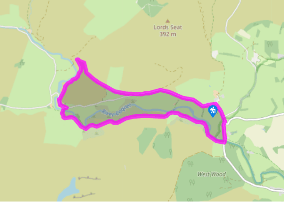
Walk left from the car park, bending right through the village to a bridge over the Alwn. Keep right again at the next junction to cross the Coquet. Some 70yds (64m) beyond, leave at a sign to Linbriggs along a track on the right. Approaching buildings, bear right through a gate to continue above the river. Eventually reaching Barrow Burn Nature Reserve, swing over a footbridge to follow the other bank.
Reaching Barrow Farm, bear left between the derelict buildings to a gate and climb away towards the right-hand corner of a conifer forest. However, after 400yds (366m), bear off right across the hillside. Initially indistinct, the way soon settles as a clear path through the upper edge of bracken.
Eventually joining a fenceline, follow it above Barrow Scar. Reach a second fence, go through a gap and keep left beside the boundary, passing through a second gap lower down to cross a stile. The ongoing path drops through a young plantation. Swing left at the bottom to pick your way across a steep bank and stream above a river bend.
Cross over a stile, carry on to a ladder stile and continue across rough pasture, curving towards the farm at Linshiels. Leave over a stile near the field corner and turn right through the yard. The exit track crosses a couple of bridges to meet a lane. Turn left then, just past farm buildings, abandon it right at a signpost to Shillmoor.
Climb to a stile and continue steeply up to the left beside a fence. A clear but narrow path soon develops, levelling above a spectacular gorge and waterfalls. Take care, particularly in wet or windy weather, as the drop below is precipitous. Maintaining your height, carry on across the hillside, shortly passing above a second gorge. Beyond a stile, the path begins to fall and eventually leads to a gate by sheep pens. Walk out and follow a broad track up the hill. Keep right at a fork to reach a waypost 50yds (46m) further on. There, turn off right on a path across the hillside. Through successive gates, pass through a small plantation and drop across a stream from which a grass track rises right to a final gate. The ongoing track climbs steadily across the open hillside.
Cresting the spur, the track levels before gently losing height, opening up a fine view along the valley. Keep ahead as a track subsequently joins from below to then pass through a hand gate (not the nearby field gate). Continue downhill, later passing through another gate and crossing a stream. The path eventually drops off the hill through a final gate onto a lane. Follow it on down the valley back to Alwinton.
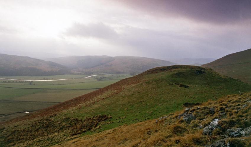
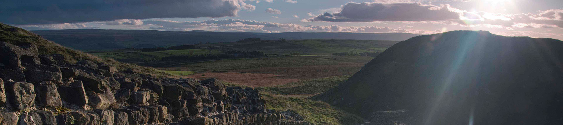
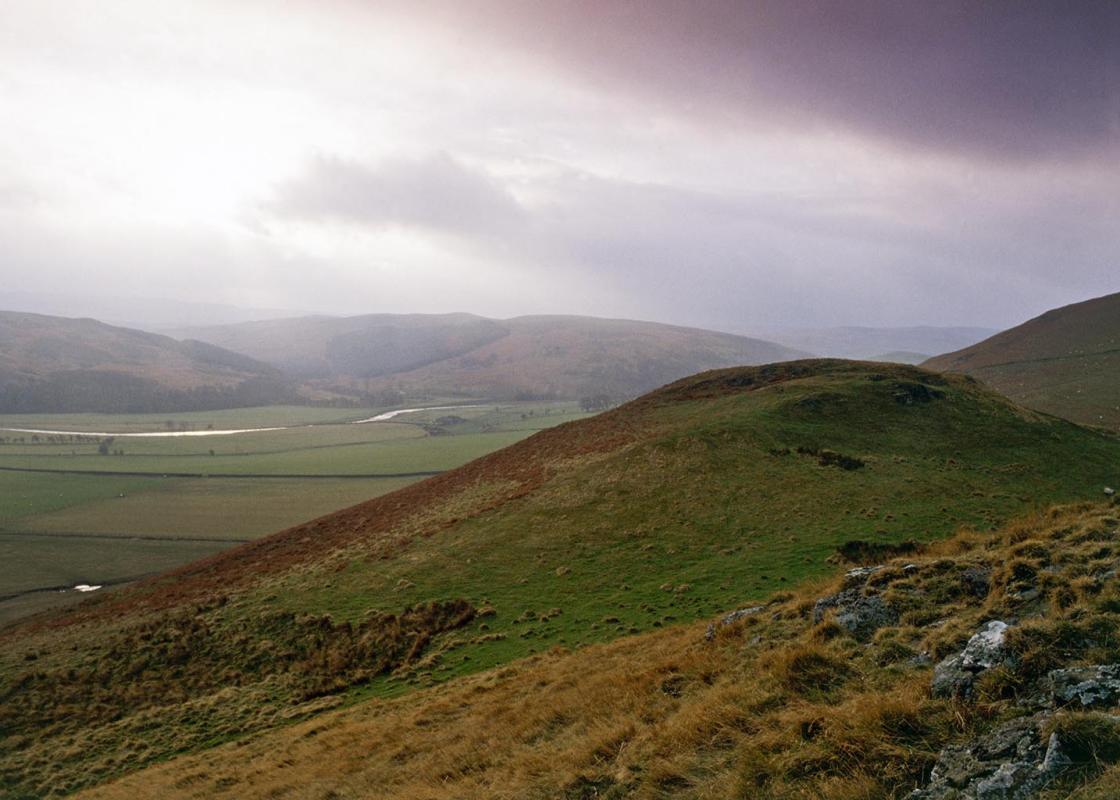
The oldest rocks in Northumberland, older even than the Alps, are those of the Cheviot Hills. They were formed by volcanic activity which began about 380 million years ago. Relentless weathering has worn down the mountains and rounded their summits, so that Cheviot itself, the highest peak, is now... 2,677ft (816m) high. The heat and pressure of further eruptions sometimes cooked and hardened the earlier rocks, so that they became more resistant to erosion and now stand as craggy tors above the Breamish and Harthope valleys. Shallow seas then washed the feet of the mountains and aided their erosion. Deposits of mud and sand were laid down and compacted into shales and sandstones. The living creatures of these seas extracted calcium salts from the water to form their shells and bones, which then added to the sediments as chalk and limestone. The successive layers of sedimentary rock are known as the cement stones and are around 340 million years old. Fell sandstones After the formation of the cement stones, the whole area became the delta of a vast river that flowed out of a North Atlantic landmass. The coarse-grained sands from this formed a layer 500–1,000ft (152–305m) thick. This became the fell sandstones that cover much of central Northumberland. Emperor Hadrian used these rocks for his wall. Later, John Dobson used them to construct many of Newcastle's buildings – the Central Railway Station is a good example. Formation of the valleys The most recent period of geological activity, beginning about one million years ago, has been characterised by the ice ages, during which ice sheets covered Northumberland's hills to a depth of 2,000ft (610m). Glaciers several hundred feet thick carved broad U-shaped valleys in the hills. After their retreat came the rivers, which continue their erosion to the present day, seaming the hillsides with narrow, V-shaped valleys that have slowly exposed the rocks of the different geological eras. The Coquet Gorge Nowhere is Northumberland's geological history better laid out to view than around the gorge of the River Coquet, west of the village of Alwinton. To the north are the volcanic Cheviot Hills, while to the south are the fell sandstones. And in the gorge itself, at Barrow Scar, the layers of the cement stones lie fully exposed.
If it’s history you’re after, there’s heaps of it in Northumberland. On Hadrian’s Wall you can imagine scarlet-cloaked Roman legionaries keeping watch for painted Pictish warriors while cursing the English weather and dreaming of home.
Walk left from the car park, bending right through the village to a bridge over the Alwn. Keep right again at the next junction to cross the Coquet. Some 70yds (64m) beyond, leave at a sign to Linbriggs along a track on the right. Approaching buildings, bear right through a gate to continue above the river. Eventually reaching Barrow Burn Nature Reserve, swing over a footbridge to follow the other bank.
1 of 6
Reaching Barrow Farm, bear left between the derelict buildings to a gate and climb away towards the right-hand corner of a conifer forest. However, after 400yds (366m), bear off right across the hillside. Initially indistinct, the way soon settles as a clear path through the upper edge of bracken.
2 of 6
Eventually joining a fenceline, follow it above Barrow Scar. Reach a second fence, go through a gap and keep left beside the boundary, passing through a second gap lower down to cross a stile. The ongoing path drops through a young plantation. Swing left at the bottom to pick your way across a steep bank and stream above a river bend.
3 of 6
Cross over a stile, carry on to a ladder stile and continue across rough pasture, curving towards the farm at Linshiels. Leave over a stile near the field corner and turn right through the yard. The exit track crosses a couple of bridges to meet a lane. Turn left then, just past farm buildings, abandon it right at a signpost to Shillmoor.
4 of 6
Climb to a stile and continue steeply up to the left beside a fence. A clear but narrow path soon develops, levelling above a spectacular gorge and waterfalls. Take care, particularly in wet or windy weather, as the drop below is precipitous. Maintaining your height, carry on across the hillside, shortly passing above a second gorge. Beyond a stile, the path begins to fall and eventually leads to a gate by sheep pens. Walk out and follow a broad track up the hill. Keep right at a fork to reach a waypost 50yds (46m) further on. There, turn off right on a path across the hillside. Through successive gates, pass through a small plantation and drop across a stream from which a grass track rises right to a final gate. The ongoing track climbs steadily across the open hillside.
5 of 6
Cresting the spur, the track levels before gently losing height, opening up a fine view along the valley. Keep ahead as a track subsequently joins from below to then pass through a hand gate (not the nearby field gate). Continue downhill, later passing through another gate and crossing a stream. The path eventually drops off the hill through a final gate onto a lane. Follow it on down the valley back to Alwinton.
The oldest rocks in Northumberland, older even than the Alps, are those of the Cheviot Hills. They were formed by volcanic activity which began about 380 million years ago. Relentless weathering has worn down the mountains and rounded their summits, so that Cheviot itself, the highest peak, is now... 2,677ft (816m) high. The heat and pressure of further eruptions sometimes cooked and hardened the earlier rocks, so that they became more resistant to erosion and now stand as craggy tors above the Breamish and Harthope valleys. Shallow seas then washed the feet of the mountains and aided their erosion. Deposits of mud and sand were laid down and compacted into shales and sandstones. The living creatures of these seas extracted calcium salts from the water to form their shells and bones, which then added to the sediments as chalk and limestone. The successive layers of sedimentary rock are known as the cement stones and are around 340 million years old. Fell sandstones After the formation of the cement stones, the whole area became the delta of a vast river that flowed out of a North Atlantic landmass. The coarse-grained sands from this formed a layer 500–1,000ft (152–305m) thick. This became the fell sandstones that cover much of central Northumberland. Emperor Hadrian used these rocks for his wall. Later, John Dobson used them to construct many of Newcastle's buildings – the Central Railway Station is a good example. Formation of the valleys The most recent period of geological activity, beginning about one million years ago, has been characterised by the ice ages, during which ice sheets covered Northumberland's hills to a depth of 2,000ft (610m). Glaciers several hundred feet thick carved broad U-shaped valleys in the hills. After their retreat came the rivers, which continue their erosion to the present day, seaming the hillsides with narrow, V-shaped valleys that have slowly exposed the rocks of the different geological eras. The Coquet Gorge Nowhere is Northumberland's geological history better laid out to view than around the gorge of the River Coquet, west of the village of Alwinton. To the north are the volcanic Cheviot Hills, while to the south are the fell sandstones. And in the gorge itself, at Barrow Scar, the layers of the cement stones lie fully exposed.
If it’s history you’re after, there’s heaps of it in Northumberland. On Hadrian’s Wall you can imagine scarlet-cloaked Roman legionaries keeping watch for painted Pictish warriors while cursing the English weather and dreaming of home.