


Pomeroy Caravan Park
Pomeroy Caravan Park is a small, family-run dairy farm, with a shop selling its own artisan ice…

The scenic upper Dove Valley has some shapely hills with sharp slopes to match.
Earl Sterndale
2.75 miles (4.4kms)
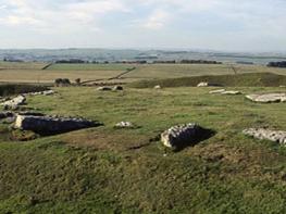
The River Dove is rightly acclaimed as one of the Peak District’s most scenic rivers, but while the lower end of the valley receives most of the visitors, the upper reaches are, if anything, more spectacular. Instead of an enclosed wooded dale with cliffs, caves and scree, the landscape is much more open but wilder, characterised by shapely peaks with smooth grassy sides and occasional bare limestone. Parkhouse Hill and Chrome Hill are two of the most eye-catching but the huge domed lump of High Wheeldon is also worth seeking out and easier to scale. It’s rather tucked away on the northern side of the valley, between Earl Sterndale and Crowdicote, but the 360-degree view from the summit is magnificent. The walk up to the very top follows well-worn footholes in the steep grassy slope – it’s straightforward enough, but whatever your fitness it will make you puff.
The walk begins at the village of Earl Sterndale and soon makes for the slopes of Hitter Hill and the upper lip of the Dove Valley. The hilltop is designated access land, so you can divert to the low rounded summit for the views if you wish. The route now descends to the lush valley bottom, before swinging sharply round to the foot of High Wheeldon. The sight of the hill’s massive southern slopes towering above, albeit smooth and green, is rather daunting, but your route to the top takes you round the back and approaches via the easier, northern shoulder.
It’s certainly worth the effort, with the 1,384ft (422m) panorama stretching many miles. At your foot is the Dove Valley, with the River Manifold across the ridge; and beyond that the Staffordshire moorlands fill the horizon, stretching round towards Axe Edge Moor and the source of the River Dove at the head of the valley. To the north the tip of the limestone quarries of Hindlow and Dowlow are just visible, with the distant outline of the Kinder massif far beyond. As a plaque on the summit trig point explains, High Wheeldon was presented to the National Trust in 1946 by Mr F A Holmes of Buxton as a memorial to the men of Derbyshire and Staffordshire who fell in the World War II.
On the northwest side of the hill is Foxhole Cave. Its small entrance is kept locked by a sturdy iron gate for archaeological reasons, since excavations have unearthed evidence of early human activity, including neolithic implements and old animal bones, which are on display at Buxton Museum. The cave system extends for about 80ft (24m) along a series of passages and chambers.
From the centre of Earl Sterndale take the public footpath which passes around the right-hand side of The Quiet Woman pub. At the path junction beside the building go straight on, signed ‘Longnor and Crowdecote’ and up the fields behind. Go over the stile in the top left corner and turn left on the upper slopes of Hitter Hill.
Keep close to the wall on your left, over another stile and alongside the wall for 100yds (91m). Turn off at the signpost to Longnor, beside a lone hawthorn tree, and here head half right down the steep, uneven hillside on a faint path. Go through the gated wall stile at the bottom and across a field to a building.
Turn left onto the track that runs past the building, and follow this gated route along the top of several fields and via Underhill farmyard. Beyond this it becomes a surfaced drive and swings round to the left to join a road.
Turn left and walk up the road, with High Wheeldon looming above. After 330yds (302m) turn right on a public footpath opposite the former Aldery Cliff quarry, now used for climbing. Follow the path past a National Trust sign and along the foot of High Wheeldon’s massive northern slopes.
At a second National Trust sign, near a kissing gate in the wall, turn right for the steep path to the summit.
Retrace your steps to the kissing gate at the bottom of the summit path and go through the gate and up through the field to the road above. Turn left and along the road back to Earl Sterndale.
Field paths and lanes, steep grassy slopes liable to be slippery when wet; several stiles
Narrow limestone valley of mainly pasture
On lead around livestock and on National Trust land
OS Explorer OL24 White Peak
Earl Sterndale village centre
None on route; nearest at Longnor, south on B5053
Read our tips to look after yourself and the environment when following this walk.
The natural features of this central English county range from the modest heights of the Peak District National Park, where Kinder Scout stands at 2,088 ft (636 m), to the depths of its remarkable underground caverns, floodlit to reveal exquisite Blue John stone. Walkers and cyclists will enjoy the High Peak Trail which extends from the Derwent Valley to the limestone plateau near Buxton, and for many, the spectacular scenery is what draws them to the area.
The county is well endowed with stately homes – most notably Chatsworth, the palatial home of the Duke and Duchess of Devonshire, with its outstanding collections of paintings, statuary and art. Other gems include the well preserved medieval Haddon Hall, the Elizabethan Hardwick Hall, and Kedleston Hall, whose entrance front has been described as the grandest Palladian façade in Britain.
The spa town of Matlock is the county’s administrative centre and other major towns of interest include Derby and the old coal mining town of Chesterfield, with its crooked spire. Around the villages of Derbyshire, look out for the ancient tradition of well dressing, the decorating of springs and wells – the precious sources of life-sustaining water – with pictures formed from flowers.
Discover more than 15,000 professionally rated places to stay, eat and visit from across the UK and Ireland.
Choose a place to stay safe in the knowledge that it has been expertly assessed by trained assessors.
Search by location or the type of place you're visiting to find your next ideal holiday experience.
Read our articles, city guides and recommended things to do for inspiration. We're here to help you explore the UK.