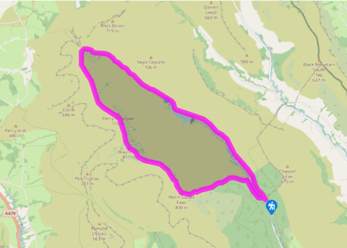
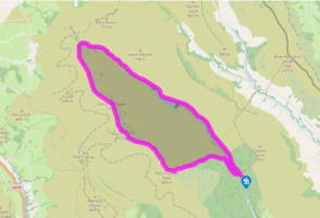
"Take the easiest way on to the highest ground in the Black Mountains above the Grwyne Fawr Reservoir."
Walk directions
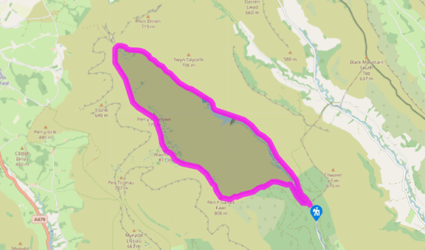
TTake the broad track at the far end of the car park and follow it out on to the road. Turn right to continue up the valley then, after about 30yds (27m), fork right on to a stony track that runs along the bottom of the forest. Follow this track ignoring a fork off to right and continue through two gates to a third gate, by a stand of trees, situated above the Grwyne Fawr Reservoir.
Keeping the trees to your left, carry on past the reservoir and up the valley. Go through another gate and continue until the track finally fords the Grwyne Fawr stream. Stay on the stony track, which now peters out to become grassy for a while before deepening into an obvious rut. Continue on to the flat ground above the steep northern escarpment, where the path meets a fence by a stile on your right.
Turn left on to a clear track and then, after 100yds (91m), turn left again by a tiny cairn on to a faint grassy track that leads up the front of a blunt spur. Follow this over numerous peaty hollows to the summit plateau of Waun Fach, easily identified by a large concrete block.
Continue on in the same direction (southeast) across a large expanse of boggy ground. There’s no clear path on this section, but there are usually plenty of footprints in the wet ground leading towards the obvious cairn-topped peak of Pen y Gadair Fawr, at the far end of the ridge. In the saddle between the two summits, you’ll pick up a faint path that initially follows the
eroded line of a stream.
The path improves as it continues, eventually leaving the stream behind and making a beeline for the peak ahead. Climb to the cairn, then continue in the same direction to drop steeply. Here you are faced with a plethora of unhelpfully brief paths vying for your attention. Take one of the middle ones, heading southeast towards what was the edge of the forest. Most of the trees have been harvested here, leaving rows of stumps. Make your way to the fence at the edge of the forested area and turn left along it.
Take particular care here because the path drops steeply down the hillside as it hugs the fence to its right. The path follows the fence all the way down to the river, crossing a stream on the way. At the river, turn right. Continue along the river bank for about 400yds (366m), then cross the bridge to the road. Turn right on to this to return to the car park.
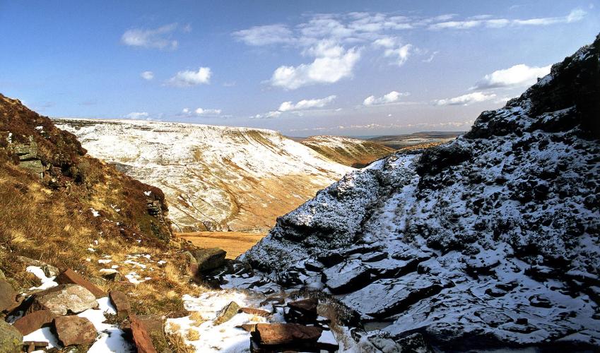
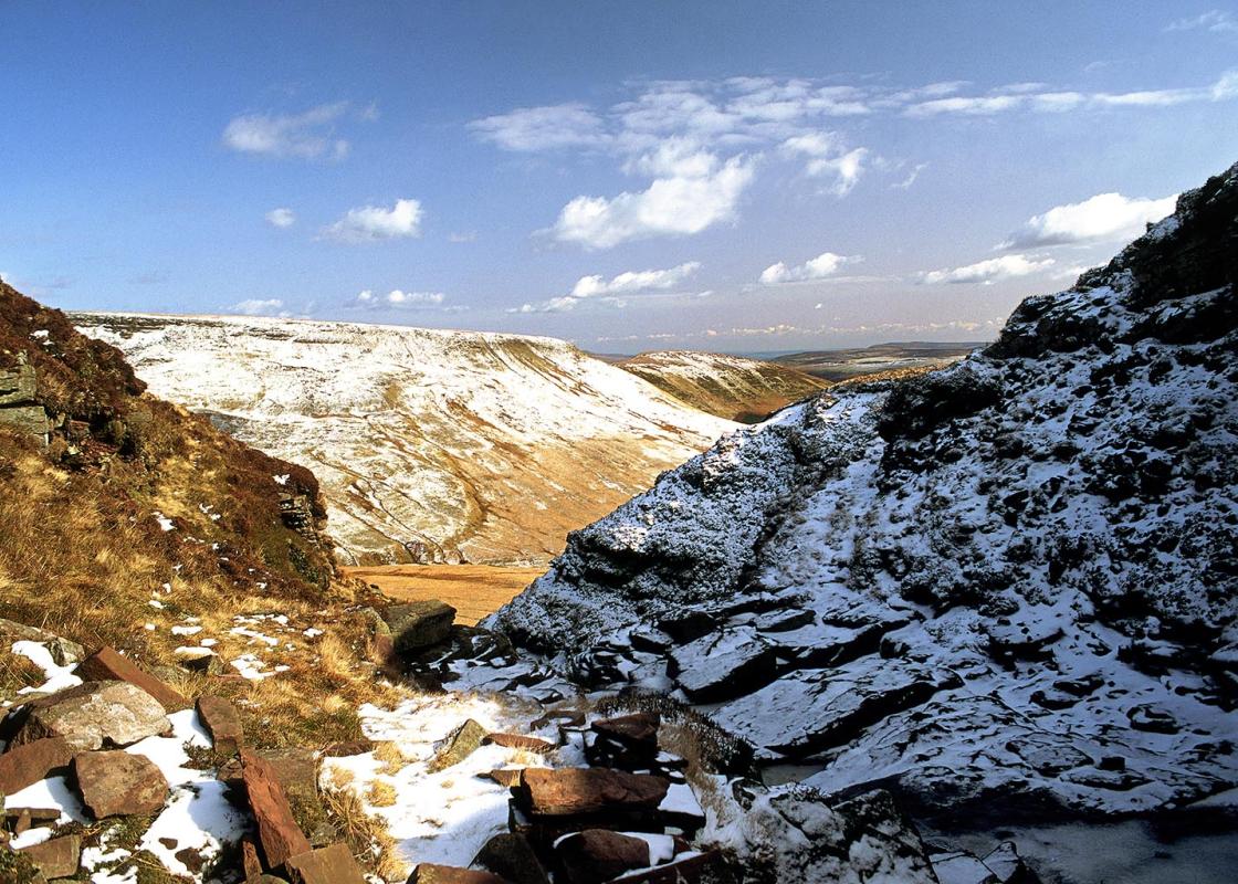
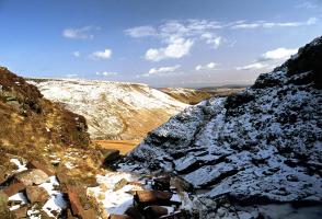
The high ground of the Black Mountains consists of a 1-mile (1.6km) long, blunt and boggy ridge that runs between the two high points of Waun Fach and Pen y Gadair Fawr. Waun Fach sneaks the gold medal for altitude; at 2,661ft (811m), it stands a less than obvious 36ft (11m) above its shapelier... neighbour. But erosion and time has reduced its lofty summit plateau to little more than a shallow peaty scoop that houses the stranded base of a long removed triangulation pillar. This has left the distinctive, conical summit of Pen y Gadair Fawr as the far more worthwhile objective. It’s dry, offers great views over the Grwyne Fechan Valley and even comes complete with a tumbledown windbreak, next to the summit cairn. The real beauty of this small cluster of rounded peaks are the valleys that drop away dramatically to either side of the ridge. The Grwyne Fechan Valley, on the western side, is the wilder and more picturesque of the two. It has no road access and its tiny brook is almost permanently in the shadow of the string of imposing peaks that define its western banks. The valley of Grwyne Fawr is the larger, however (Fawr means large or great). Its windswept rolling moorland cradles a large reservoir that provides a scenic focal point for walkers and sightseers alike. It’s fed by the tumbling Grwyne Fawr river, a typical fast-flowing mountain stream that rises out of the boggy plateau at its head. The easy angle of the valley means that its grassy floor, penetrated by a good track for most of its length, offers a gentle knee-up on to the higher ground and this provides the easiest approach to most of the surrounding peaks. Lower down the valley, beneath the reservoir, the walls steepen and their wooded slopes provide a short but extremely sharp exit from the lofty flanks of Pen y Gadair Fawr.
The largest unitary authority in Wales, Powys covers an area of approximately 2,000 square miles. Much of that is mountainous because it actually has the lowest population density of all the Welsh counties.
"Take the easiest way on to the highest ground in the Black Mountains above the Grwyne Fawr Reservoir."
Walk details
4hrs
Difficulty:
Hard
Gradient:
Challenging
Distance:
9.25 miles (14.9kms)
Ascent:
2000ft (610m)
Walk directions
TTake the broad track at the far end of the car park and follow it out on to the road. Turn right to continue up the valley then, after about 30yds (27m), fork right on to a stony track that runs along the bottom of the forest. Follow this track ignoring a fork off to right and continue through two gates to a third gate, by a stand of trees, situated above the Grwyne Fawr Reservoir.
1 of 6
Keeping the trees to your left, carry on past the reservoir and up the valley. Go through another gate and continue until the track finally fords the Grwyne Fawr stream. Stay on the stony track, which now peters out to become grassy for a while before deepening into an obvious rut. Continue on to the flat ground above the steep northern escarpment, where the path meets a fence by a stile on your right.
2 of 6
Turn left on to a clear track and then, after 100yds (91m), turn left again by a tiny cairn on to a faint grassy track that leads up the front of a blunt spur. Follow this over numerous peaty hollows to the summit plateau of Waun Fach, easily identified by a large concrete block.
3 of 6
Continue on in the same direction (southeast) across a large expanse of boggy ground. There’s no clear path on this section, but there are usually plenty of footprints in the wet ground leading towards the obvious cairn-topped peak of Pen y Gadair Fawr, at the far end of the ridge. In the saddle between the two summits, you’ll pick up a faint path that initially follows the
eroded line of a stream.
4 of 6
The path improves as it continues, eventually leaving the stream behind and making a beeline for the peak ahead. Climb to the cairn, then continue in the same direction to drop steeply. Here you are faced with a plethora of unhelpfully brief paths vying for your attention. Take one of the middle ones, heading southeast towards what was the edge of the forest. Most of the trees have been harvested here, leaving rows of stumps. Make your way to the fence at the edge of the forested area and turn left along it.
5 of 6
Take particular care here because the path drops steeply down the hillside as it hugs the fence to its right. The path follows the fence all the way down to the river, crossing a stream on the way. At the river, turn right. Continue along the river bank for about 400yds (366m), then cross the bridge to the road. Turn right on to this to return to the car park.
The high ground of the Black Mountains consists of a 1-mile (1.6km) long, blunt and boggy ridge that runs between the two high points of Waun Fach and Pen y Gadair Fawr. Waun Fach sneaks the gold medal for altitude; at 2,661ft (811m), it stands a less than obvious 36ft (11m) above its shapelier... neighbour. But erosion and time has reduced its lofty summit plateau to little more than a shallow peaty scoop that houses the stranded base of a long removed triangulation pillar. This has left the distinctive, conical summit of Pen y Gadair Fawr as the far more worthwhile objective. It’s dry, offers great views over the Grwyne Fechan Valley and even comes complete with a tumbledown windbreak, next to the summit cairn. The real beauty of this small cluster of rounded peaks are the valleys that drop away dramatically to either side of the ridge. The Grwyne Fechan Valley, on the western side, is the wilder and more picturesque of the two. It has no road access and its tiny brook is almost permanently in the shadow of the string of imposing peaks that define its western banks. The valley of Grwyne Fawr is the larger, however (Fawr means large or great). Its windswept rolling moorland cradles a large reservoir that provides a scenic focal point for walkers and sightseers alike. It’s fed by the tumbling Grwyne Fawr river, a typical fast-flowing mountain stream that rises out of the boggy plateau at its head. The easy angle of the valley means that its grassy floor, penetrated by a good track for most of its length, offers a gentle knee-up on to the higher ground and this provides the easiest approach to most of the surrounding peaks. Lower down the valley, beneath the reservoir, the walls steepen and their wooded slopes provide a short but extremely sharp exit from the lofty flanks of Pen y Gadair Fawr.
The largest unitary authority in Wales, Powys covers an area of approximately 2,000 square miles. Much of that is mountainous because it actually has the lowest population density of all the Welsh counties.