"A moderate walk around an upland district steeped in the history of Lancashire, Yorkshire and the textile industry"
Walk directions
A footpath parallels the lane toward the village. Where it rejoins on a bend, go through a gate on the right and follow a field trod half right. Over a stile, carry on by a fence to a gate and bear left to another stile.
Follow the fence beside Bracken Hill, continuing beyond the corner to a plank spanning a stream. Maintain the diagonal to a footbridge in the next gully. Walk on by the hedge, crossing a track to continue along the field top, than go through a gateway and bear right towards distant Pendle Hill. Over a stile in the corner, cross another track and maintain the diagonal line to a gate partway along the far wall. Carry on to Higher Stunstead Farm, passing behind the buildings to reach a track.
Turn left towards Boulsworth. Go over a cattle grid and leave the track through a gate ahead. Walk upfield beside a stream, fording it in the corner to continue through a gate on its opposite bank. Entering the yard at Little Laith, pass right of the cottage and beyond a gate, then follow the right boundary towards New Laithe Farm.
Go through a gate to the left of the barn and walk briefly forward to a second gate. Follow a track behind the buildings to a waymarked gate on the left. Head across an intervening stile to a four-way fingerpost and keep going over more stiles, shortly passing Mean Moss cottage. Meeting a track, go briefly left, leaving before a cattle grid through a gate on the right. Climb by the right wall to a stile and cut left to another. Follow the fence beside Beaver Farm. Through a gate, head downfield to a stile in the bottom corner. Walk out to a track.
Go left. Where it later swings left, keep ahead on a grass track above the deepening gully of Saucer Hill Clough.
Eventually dropping to a junction by a bridge, leave the path through a gate ahead. Bear right at a fork, descending between young trees to a gate. Continue briefly by the stream before gaining height above mature wood. Reaching a kissing gate, enter the wood and follow a path left, descending eventually to a bridge. On the far bank, go left beside the stream, shortly rising to a kissing gate. Walk forward to a stile and drop back towards the stream, leaving through a kissing gate onto a track.
Turn left past the visitor centre and ruined hall to Wycoller. Cross the packhorse bridge into the village and follow the onward lane back to the car park.
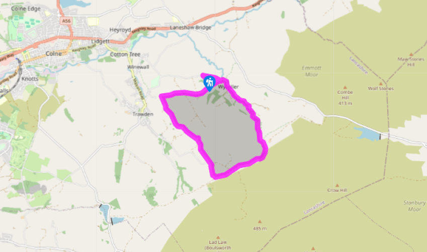
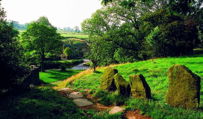
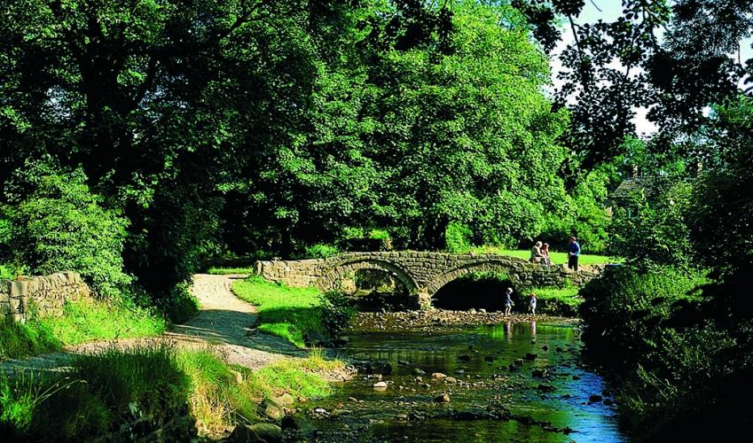
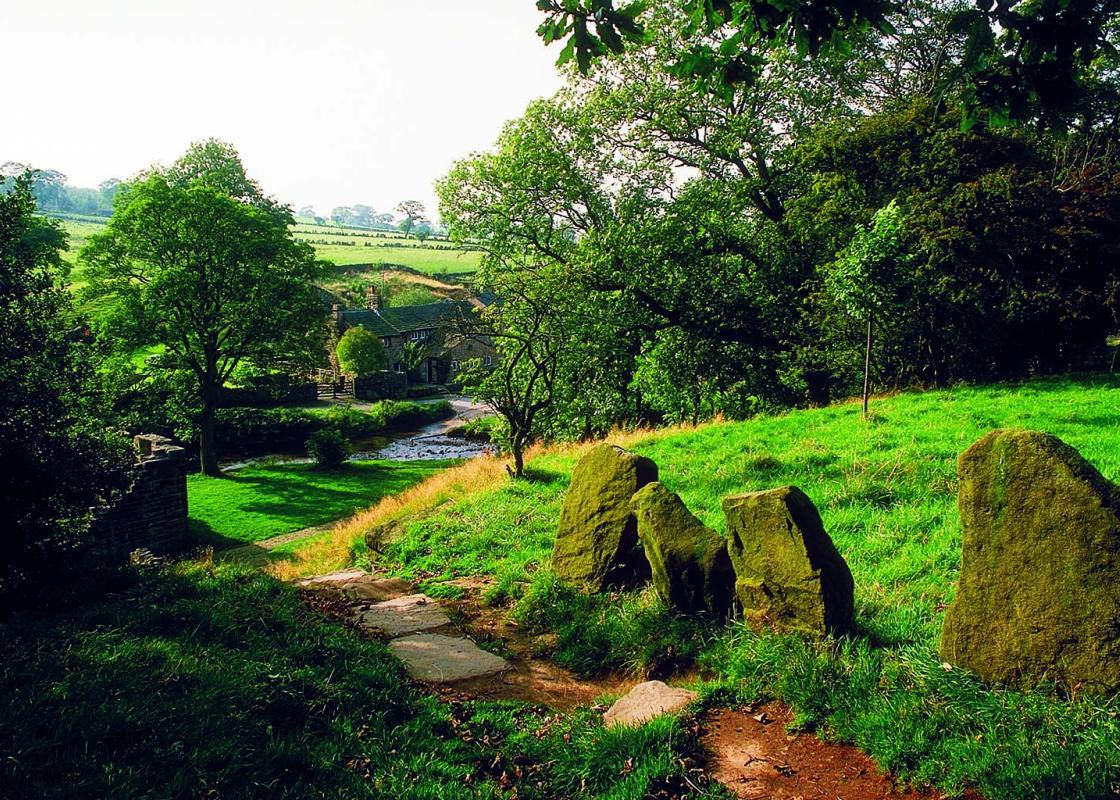
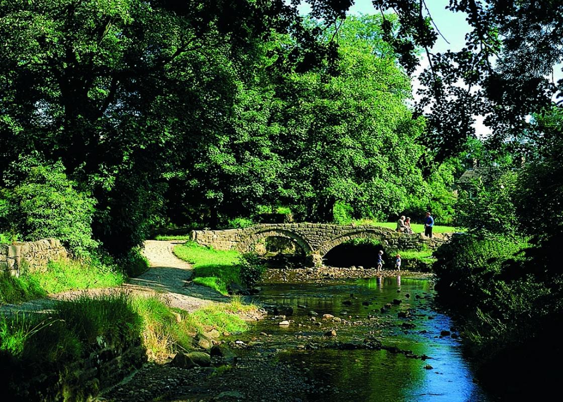
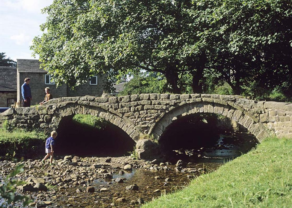
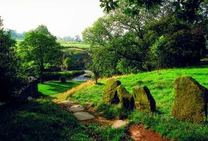
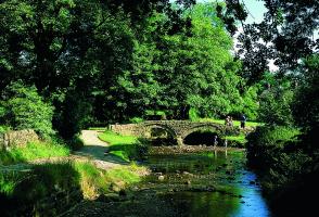
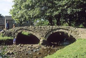
Everyone associates the Brontës with Yorkshire, but they had strong Lancashire connections too. As children the sisters lived in the north of the county, attending school at Cowan Bridge, only later moving to Haworth where they wrote their famous books. Haworth is only 9 miles (14.5km) from... Wycoller and today you step out on a small section of the waymarked Brontë Way. Handloom weavers Another hint of Yorkshire is the tradition of weaving wool, rather than the cotton usually associated with Lancashire. Trawden had several mills but Wycoller was a community of handloom weavers. As the Industrial Revolution developed, they were unable to compete with the growth of larger, powered mills and the village became an isolated backwater. Sheep and cattle Naturally sheep farming is important here, especially on the higher ground, but the area has a long tradition of cattle rearing too. The distinctive walls of large upright slabs that are seen in places are known as vaccary walls – a vaccary being a cattle farm. Quiet first half The first half of the walk crosses these pastures, though you will see more sheep grazing than cattle today. For much of the way you climb gently, with wide views towards Pendle and the Yorkshire Dales, finally emerging on to the open moors. The route now follows an old trackway along the edge of the moor before swinging back down into Turnhole Clough. The path skirts above the woods before dropping into them and crossing the beck. Just below you meet the main Wycoller Beck. About 300yds (274m) below the confluence is the Clam Bridge, believed to be more than 1,000 years old and made of a single massive slab of gritstone – at least, it was a single slab until 1989, when an exceptionally heavy flood swept the bridge away. It was repaired and replaced, but damaged again the following year. Though the repair has been skilfully done, you can clearly see where the slab was broken by the torrent of water. Wycoller hamlet Following the stream, you soon come into Wycoller hamlet. Despite its simple construction of stone slabs, the clapper bridge is a relatively recent affair, at most only 200 years old. The packhorse bridge is certainly more ancient, possibly over 700 years old. The low parapets, which sometimes alarm nervous parents (though usually not their children), are an essential feature for a packhorse bridge as the animals would be heavily burdened with huge bales of wool.Nearby stand the ruins of Wycoller Hall. Originally built in the 16th century, the Hall was considerably enlarged 200 years later by Henry Cunliffe. Unfortunately the lavish works left him heavily in debt and after his death, in 1818, the estate was broken up. It's thought that the Hall was largely derelict by the time the Brontë sisters knew about it and that it inspired Ferndean Manor in Charlotte's Jane Eyre (1847).
Lancashire was at the centre of the British cotton industry in the 19th century, which lead to the urbanization of great tracts of the area. The cotton boom came and went, but the industrial profile remains.
"A moderate walk around an upland district steeped in the history of Lancashire, Yorkshire and the textile industry"
Walk details
2hrs
Difficulty:
Medium
Gradient:
Gentle
Distance:
5.5 miles (8.9kms)
Ascent:
607ft (185m)
Walk directions
A footpath parallels the lane toward the village. Where it rejoins on a bend, go through a gate on the right and follow a field trod half right. Over a stile, carry on by a fence to a gate and bear left to another stile.
1 of 7
Follow the fence beside Bracken Hill, continuing beyond the corner to a plank spanning a stream. Maintain the diagonal to a footbridge in the next gully. Walk on by the hedge, crossing a track to continue along the field top, than go through a gateway and bear right towards distant Pendle Hill. Over a stile in the corner, cross another track and maintain the diagonal line to a gate partway along the far wall. Carry on to Higher Stunstead Farm, passing behind the buildings to reach a track.
2 of 7
Turn left towards Boulsworth. Go over a cattle grid and leave the track through a gate ahead. Walk upfield beside a stream, fording it in the corner to continue through a gate on its opposite bank. Entering the yard at Little Laith, pass right of the cottage and beyond a gate, then follow the right boundary towards New Laithe Farm.
3 of 7
Go through a gate to the left of the barn and walk briefly forward to a second gate. Follow a track behind the buildings to a waymarked gate on the left. Head across an intervening stile to a four-way fingerpost and keep going over more stiles, shortly passing Mean Moss cottage. Meeting a track, go briefly left, leaving before a cattle grid through a gate on the right. Climb by the right wall to a stile and cut left to another. Follow the fence beside Beaver Farm. Through a gate, head downfield to a stile in the bottom corner. Walk out to a track.
4 of 7
Go left. Where it later swings left, keep ahead on a grass track above the deepening gully of Saucer Hill Clough.
5 of 7
Eventually dropping to a junction by a bridge, leave the path through a gate ahead. Bear right at a fork, descending between young trees to a gate. Continue briefly by the stream before gaining height above mature wood. Reaching a kissing gate, enter the wood and follow a path left, descending eventually to a bridge. On the far bank, go left beside the stream, shortly rising to a kissing gate. Walk forward to a stile and drop back towards the stream, leaving through a kissing gate onto a track.
6 of 7
Turn left past the visitor centre and ruined hall to Wycoller. Cross the packhorse bridge into the village and follow the onward lane back to the car park.
Everyone associates the Brontës with Yorkshire, but they had strong Lancashire connections too. As children the sisters lived in the north of the county, attending school at Cowan Bridge, only later moving to Haworth where they wrote their famous books. Haworth is only 9 miles (14.5km) from... Wycoller and today you step out on a small section of the waymarked Brontë Way. Handloom weavers Another hint of Yorkshire is the tradition of weaving wool, rather than the cotton usually associated with Lancashire. Trawden had several mills but Wycoller was a community of handloom weavers. As the Industrial Revolution developed, they were unable to compete with the growth of larger, powered mills and the village became an isolated backwater. Sheep and cattle Naturally sheep farming is important here, especially on the higher ground, but the area has a long tradition of cattle rearing too. The distinctive walls of large upright slabs that are seen in places are known as vaccary walls – a vaccary being a cattle farm. Quiet first half The first half of the walk crosses these pastures, though you will see more sheep grazing than cattle today. For much of the way you climb gently, with wide views towards Pendle and the Yorkshire Dales, finally emerging on to the open moors. The route now follows an old trackway along the edge of the moor before swinging back down into Turnhole Clough. The path skirts above the woods before dropping into them and crossing the beck. Just below you meet the main Wycoller Beck. About 300yds (274m) below the confluence is the Clam Bridge, believed to be more than 1,000 years old and made of a single massive slab of gritstone – at least, it was a single slab until 1989, when an exceptionally heavy flood swept the bridge away. It was repaired and replaced, but damaged again the following year. Though the repair has been skilfully done, you can clearly see where the slab was broken by the torrent of water. Wycoller hamlet Following the stream, you soon come into Wycoller hamlet. Despite its simple construction of stone slabs, the clapper bridge is a relatively recent affair, at most only 200 years old. The packhorse bridge is certainly more ancient, possibly over 700 years old. The low parapets, which sometimes alarm nervous parents (though usually not their children), are an essential feature for a packhorse bridge as the animals would be heavily burdened with huge bales of wool.Nearby stand the ruins of Wycoller Hall. Originally built in the 16th century, the Hall was considerably enlarged 200 years later by Henry Cunliffe. Unfortunately the lavish works left him heavily in debt and after his death, in 1818, the estate was broken up. It's thought that the Hall was largely derelict by the time the Brontë sisters knew about it and that it inspired Ferndean Manor in Charlotte's Jane Eyre (1847).
Lancashire was at the centre of the British cotton industry in the 19th century, which lead to the urbanization of great tracts of the area. The cotton boom came and went, but the industrial profile remains.