"A wild walk to a deceptive 'summit', which proves an unrivalled viewpoint overlooking the sweeping Bowland Fells"
Walk directions
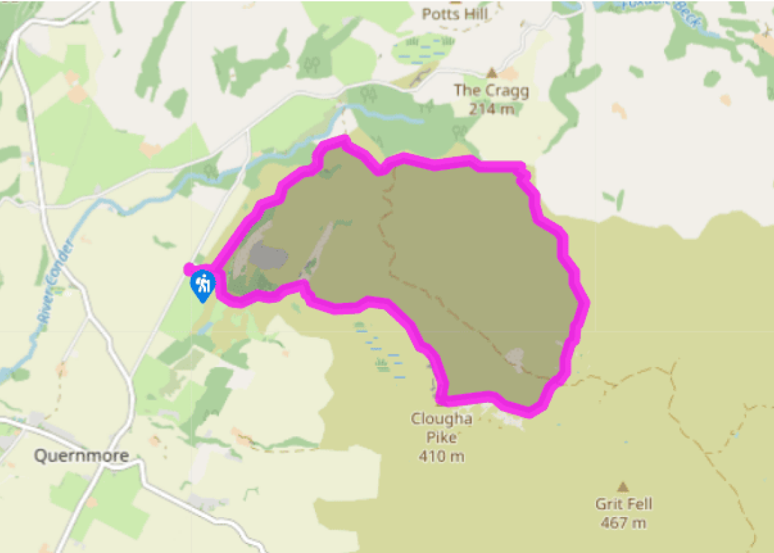
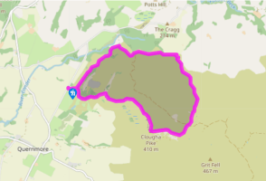
Leave the top-right corner of the car park through a gate along a grass track. Keep right at a fork and carry on for 0.5 miles (800m) to Ottergear Bridge.
The path winds on, shortly reaching a T-junction. Go right along a track, later dipping to pass through a gate at the base of a rocky clough. After a short pull, the track bends right.
There, join a narrow path on the left and contour a heather slope above Cragg Wood, later falling into the upper valley of the River Conder. Towards the top, cross a side stream, the infant river, and walk on to an Access Land sign.
Swing right, climbing on a vague trod. The way soon levels to an area of marsh. Skirt around on the right and pick up a more obvious path beyond that climbs gently beside a groove, initially paralleling a wall some 50yds (46m) to the left. With the way now clear, carry on up the hill, now diverging from the wall and passing occasional shooting butts.
After a mile (1.6km), cross a gravel estate track to a fainter grass path opposite and continue up the hillside for another 0.25 miles (400m) to meet a crossing path running along the top. To the right, it undulates along the broad, rocky ridge. After crossing a fence stile, the summit trig of Clougha Pike comes into view, peeping above a shelter wall.
Turn right, heading almost due north and descending to a large cairn. The path loses height more steeply beyond, later converging with a fence from the right. Follow it down to a wall.
Crossing the wall, go right to continue down beside it. The path shortly moves away, dropping through a break in the bouldery scar and across a more level apron of rush to a gate by the corner of another wall.
Follow a trod straight down the hill. Lower down, as the ground steepens, wind right into the base of Windy Clough. Over a ladder stile by a junction of walls, the path descends left through bracken heath and into woodland. Emerging from the trees, carry on to join a walkway skirting a marsh. Meeting a crossing track at the end, go right and then, at a fork, bear left over a rise. Go left again at the next junction back to the car park.
Clougha Pike is the finest viewpoint in the Bowland Fells, possibly in the whole of Lancashire. There's lots to see at closer quarters too and the walk is always rewarding, but on a clear day it's nothing short of magnificent. Although the ground is sometimes very rough, the ascent is rarely very... steep and the views expand with every stride. The ridge of Clougha The opening stages are almost level. After crossing the little aqueduct called Ottergear Bridge, the route swings round and climbs a little, then drops into a small, sharp-cut valley. This is the first of several curious channels, some of which cut right through the ridge of Clougha. These are relics from the end of the ice age. The edge of the ice sheet was stationary for a while in this area, dammed up behind the ridge. Torrents of meltwater pouring off the ice, and probably sometimes running underneath it, carved the network of channels. The most striking example is Windy Clough, seen near the end of the walk. Heather moorland Now the walk begins its steady ascent across Clougha's broad flanks. Apart from a few wet patches marked by rushes and cotton grass, the dominant vegetation is heather and bilberry. Heather moorland is widespread in Britain but rare in most of the rest of Europe. Geology, climate and soils are partly responsible, but the management of the land is equally significant. Controlled burning of areas of moor encourages the heather to produce new shoots, the main food for the red grouse. Like it or not, grouse shooting for sport is part of the ecology of these moors. When the rocky crest of the ridge is reached, the climbing is over. The last stretch is generally level and when the summit of Clougha appears it definitely is slightly below you. This hardly detracts from the view, even though a sector is blocked by the higher ground of Grit Fell and beyond it Ward's Stone, the highest summit in Lancashire. Distant views The Clwydian Hills in Wales are apparent much more often than the higher, but more distant, peaks of Snowdonia. The distinctive profile of the Isle of Man, over 60 miles (97km) away in the Irish Sea, is also visible on a clear day. However, what grabs most of the attention is the sweep of the Lakeland skyline and the continuation of high ground eastwards, over the Howgill Fells and into Yorkshire, where the Three Peaks of Whernside, Ingleborough and Pen-y-ghent are dominant. As you descend, the nick of Little Windy Clough appears over your right shoulder, and then the much deeper Windy Clough appears. The stream draining Windy Clough runs underground where we cross it but surfaces again a little lower down.
Lancashire was at the centre of the British cotton industry in the 19th century, which lead to the urbanization of great tracts of the area. The cotton boom came and went, but the industrial profile remains.
"A wild walk to a deceptive 'summit', which proves an unrivalled viewpoint overlooking the sweeping Bowland Fells"
Walk details
2hrs 15min
Difficulty:
Hard
Gradient:
Moderate
Distance:
5.25 miles (8.4kms)
Ascent:
1099ft (335m)
Walk directions
Leave the top-right corner of the car park through a gate along a grass track. Keep right at a fork and carry on for 0.5 miles (800m) to Ottergear Bridge.
1 of 8
The path winds on, shortly reaching a T-junction. Go right along a track, later dipping to pass through a gate at the base of a rocky clough. After a short pull, the track bends right.
2 of 8
There, join a narrow path on the left and contour a heather slope above Cragg Wood, later falling into the upper valley of the River Conder. Towards the top, cross a side stream, the infant river, and walk on to an Access Land sign.
3 of 8
Swing right, climbing on a vague trod. The way soon levels to an area of marsh. Skirt around on the right and pick up a more obvious path beyond that climbs gently beside a groove, initially paralleling a wall some 50yds (46m) to the left. With the way now clear, carry on up the hill, now diverging from the wall and passing occasional shooting butts.
4 of 8
After a mile (1.6km), cross a gravel estate track to a fainter grass path opposite and continue up the hillside for another 0.25 miles (400m) to meet a crossing path running along the top. To the right, it undulates along the broad, rocky ridge. After crossing a fence stile, the summit trig of Clougha Pike comes into view, peeping above a shelter wall.
5 of 8
Turn right, heading almost due north and descending to a large cairn. The path loses height more steeply beyond, later converging with a fence from the right. Follow it down to a wall.
6 of 8
Crossing the wall, go right to continue down beside it. The path shortly moves away, dropping through a break in the bouldery scar and across a more level apron of rush to a gate by the corner of another wall.
7 of 8
Follow a trod straight down the hill. Lower down, as the ground steepens, wind right into the base of Windy Clough. Over a ladder stile by a junction of walls, the path descends left through bracken heath and into woodland. Emerging from the trees, carry on to join a walkway skirting a marsh. Meeting a crossing track at the end, go right and then, at a fork, bear left over a rise. Go left again at the next junction back to the car park.
Clougha Pike is the finest viewpoint in the Bowland Fells, possibly in the whole of Lancashire. There's lots to see at closer quarters too and the walk is always rewarding, but on a clear day it's nothing short of magnificent. Although the ground is sometimes very rough, the ascent is rarely very... steep and the views expand with every stride. The ridge of Clougha The opening stages are almost level. After crossing the little aqueduct called Ottergear Bridge, the route swings round and climbs a little, then drops into a small, sharp-cut valley. This is the first of several curious channels, some of which cut right through the ridge of Clougha. These are relics from the end of the ice age. The edge of the ice sheet was stationary for a while in this area, dammed up behind the ridge. Torrents of meltwater pouring off the ice, and probably sometimes running underneath it, carved the network of channels. The most striking example is Windy Clough, seen near the end of the walk. Heather moorland Now the walk begins its steady ascent across Clougha's broad flanks. Apart from a few wet patches marked by rushes and cotton grass, the dominant vegetation is heather and bilberry. Heather moorland is widespread in Britain but rare in most of the rest of Europe. Geology, climate and soils are partly responsible, but the management of the land is equally significant. Controlled burning of areas of moor encourages the heather to produce new shoots, the main food for the red grouse. Like it or not, grouse shooting for sport is part of the ecology of these moors. When the rocky crest of the ridge is reached, the climbing is over. The last stretch is generally level and when the summit of Clougha appears it definitely is slightly below you. This hardly detracts from the view, even though a sector is blocked by the higher ground of Grit Fell and beyond it Ward's Stone, the highest summit in Lancashire. Distant views The Clwydian Hills in Wales are apparent much more often than the higher, but more distant, peaks of Snowdonia. The distinctive profile of the Isle of Man, over 60 miles (97km) away in the Irish Sea, is also visible on a clear day. However, what grabs most of the attention is the sweep of the Lakeland skyline and the continuation of high ground eastwards, over the Howgill Fells and into Yorkshire, where the Three Peaks of Whernside, Ingleborough and Pen-y-ghent are dominant. As you descend, the nick of Little Windy Clough appears over your right shoulder, and then the much deeper Windy Clough appears. The stream draining Windy Clough runs underground where we cross it but surfaces again a little lower down.
Lancashire was at the centre of the British cotton industry in the 19th century, which lead to the urbanization of great tracts of the area. The cotton boom came and went, but the industrial profile remains.