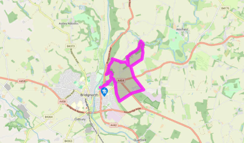
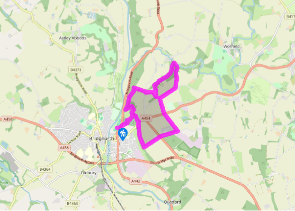
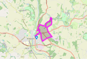
Follow the car park access track to the A442, turn left, then right, signposted ‘cemetery’. At the cemetery take a footpath, left, climbing steeply. The gradient eases: turn right on a fenced path, then climb again through woods. At the top keep left to reach a waymarked junction.
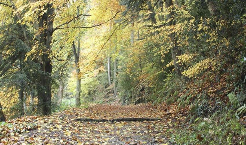
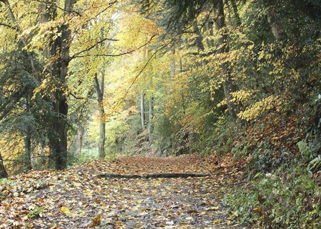
Fork left, descending quite steeply before the path (known as Jacob’s Ladder) levels out to contour in an undulating fashion round High Rock and then Pendlestone Rock. At a junction, keep to the higher path, which soon swings right. Leaving the trees behind, it passes Woodside Farm, then merges with the farm access track.
Meeting a lane, turn right for a few paces, then left at a footpath sign. Pass a house and go through a gate into a field. Proceed along the edge almost to the end, then turn right to a gate opposite. Turn left into a narrow field and descend in the bottom of a valley.
Meet a track by a sandstone building and turn right along a steep-sided valley. Where the main track bends right, keep straight on along a grassy path through bracken. Eventually you come to a junction with a sandy track beside the River Worfe.
Your onward route is to the right, but first it’s worth a short detour to the left to explore the lovely hamlet of Rindleford. Resuming the walk, return to the junction and follow the sandy track, first by the river then swinging right to climb gently out of the valley.
Turn right when you reach a lane. After 600yds (549m) turn left at a waymarked gate and follow a footpath along a field edge. This leads to the A454 and continues on the other side, past a housing estate called The Hobbins.
Turn right on another road, which runs past Stanmore Country Park, to the A454. Cross to a track opposite, by Hermitage Farm. Follow the track round right at the top. As you approach metal gates, go through a gap in the hedge and continue along a narrow path, always close to the edge of the wood. Audibly nearing the B4363, look for a parallel path on the left, which descends past The Hermitage. Cross the road, go up to a lamppost and join a narrow path on the left. Follow this, with very steep slopes on the left until you meet point 2. Now, a sharp left turn takes you back down past the cemetery to the A442 and Severn Park.
The most dramatic of Shropshire towns, Bridgnorth clings to the top of a cliff. Or at least High Town does – for Bridgnorth is two towns in one, with Low Town occupying the riverside. The two are linked by a modern road, seven ancient stairways, a cartway and a funicular railway of 1892. Until... recently it was Britain’s only inland cliff railway and it remains the only electrically powered one, with colliery-type winding gear. It’s often said that Bridgnorth, with its clifftop setting, resembles a continental town and if you do this walk you’ll get an inkling of what is meant. It’s only when you climb to the viewpoints on High Rock and Pendlestone Rock that you really get to see Bridgnorth in context. The modern town sprawls in the background, but the old town is distinct from it in a way reminiscent of many European countries. The Spanish, for instance, usually preserve an old town and build a modern one next to it, while here in Britain we knock it down and build on top. This is not the case in Bridgnorth. It does look almost continental from High Rock, perched on its cliff and watched over by its twin church towers. The red sandstone one to the north belongs to St Leonard’s, the original parish church. During the Civil War it was used as an ammunition store by Royalist troops. When the Roundheads scored a direct hit, the ensuing fire proved disastrous. It was skilfully rebuilt, but is now redundant. The classical-style church to the south is built of white sandstone and dedicated to St Mary Magdalene. It was constructed between 1792 and 1794 to the design of Thomas Telford, replacing the Norman chapel attached to Bridgnorth Castle, and is now the parish church. Bridgnorth’s cliffs are formed from sandstone, a soft, easily eroded, easily hewn rock. The sandstone country of south Shropshire, north Worcestershire and south Staffordshire is riddled with caves, natural and man-made, many of which were inhabited until the 1960s. This is not so grim as it sounds – caves are warm in winter and cool in summer. When equipped with electricity and piped water, they can be far more salubrious than some types of conventional housing. There are still plenty of former cave-homes in Bridgnorth, including some on Cartway.
Perhaps nowhere else in England will you find a county so deeply rural and with so much variety as Shropshire. Choose a clear day, climb to the top of The Wrekin, and look down on that ‘land of lost content’ so wistfully evoked by A E Housman.
Follow the car park access track to the A442, turn left, then right, signposted ‘cemetery’. At the cemetery take a footpath, left, climbing steeply. The gradient eases: turn right on a fenced path, then climb again through woods. At the top keep left to reach a waymarked junction.
1 of 7
Fork left, descending quite steeply before the path (known as Jacob’s Ladder) levels out to contour in an undulating fashion round High Rock and then Pendlestone Rock. At a junction, keep to the higher path, which soon swings right. Leaving the trees behind, it passes Woodside Farm, then merges with the farm access track.
2 of 7
Meeting a lane, turn right for a few paces, then left at a footpath sign. Pass a house and go through a gate into a field. Proceed along the edge almost to the end, then turn right to a gate opposite. Turn left into a narrow field and descend in the bottom of a valley.
3 of 7
Meet a track by a sandstone building and turn right along a steep-sided valley. Where the main track bends right, keep straight on along a grassy path through bracken. Eventually you come to a junction with a sandy track beside the River Worfe.
4 of 7
Your onward route is to the right, but first it’s worth a short detour to the left to explore the lovely hamlet of Rindleford. Resuming the walk, return to the junction and follow the sandy track, first by the river then swinging right to climb gently out of the valley.
5 of 7
Turn right when you reach a lane. After 600yds (549m) turn left at a waymarked gate and follow a footpath along a field edge. This leads to the A454 and continues on the other side, past a housing estate called The Hobbins.
6 of 7
Turn right on another road, which runs past Stanmore Country Park, to the A454. Cross to a track opposite, by Hermitage Farm. Follow the track round right at the top. As you approach metal gates, go through a gap in the hedge and continue along a narrow path, always close to the edge of the wood. Audibly nearing the B4363, look for a parallel path on the left, which descends past The Hermitage. Cross the road, go up to a lamppost and join a narrow path on the left. Follow this, with very steep slopes on the left until you meet point 2. Now, a sharp left turn takes you back down past the cemetery to the A442 and Severn Park.
The most dramatic of Shropshire towns, Bridgnorth clings to the top of a cliff. Or at least High Town does – for Bridgnorth is two towns in one, with Low Town occupying the riverside. The two are linked by a modern road, seven ancient stairways, a cartway and a funicular railway of 1892. Until... recently it was Britain’s only inland cliff railway and it remains the only electrically powered one, with colliery-type winding gear. It’s often said that Bridgnorth, with its clifftop setting, resembles a continental town and if you do this walk you’ll get an inkling of what is meant. It’s only when you climb to the viewpoints on High Rock and Pendlestone Rock that you really get to see Bridgnorth in context. The modern town sprawls in the background, but the old town is distinct from it in a way reminiscent of many European countries. The Spanish, for instance, usually preserve an old town and build a modern one next to it, while here in Britain we knock it down and build on top. This is not the case in Bridgnorth. It does look almost continental from High Rock, perched on its cliff and watched over by its twin church towers. The red sandstone one to the north belongs to St Leonard’s, the original parish church. During the Civil War it was used as an ammunition store by Royalist troops. When the Roundheads scored a direct hit, the ensuing fire proved disastrous. It was skilfully rebuilt, but is now redundant. The classical-style church to the south is built of white sandstone and dedicated to St Mary Magdalene. It was constructed between 1792 and 1794 to the design of Thomas Telford, replacing the Norman chapel attached to Bridgnorth Castle, and is now the parish church. Bridgnorth’s cliffs are formed from sandstone, a soft, easily eroded, easily hewn rock. The sandstone country of south Shropshire, north Worcestershire and south Staffordshire is riddled with caves, natural and man-made, many of which were inhabited until the 1960s. This is not so grim as it sounds – caves are warm in winter and cool in summer. When equipped with electricity and piped water, they can be far more salubrious than some types of conventional housing. There are still plenty of former cave-homes in Bridgnorth, including some on Cartway.
Perhaps nowhere else in England will you find a county so deeply rural and with so much variety as Shropshire. Choose a clear day, climb to the top of The Wrekin, and look down on that ‘land of lost content’ so wistfully evoked by A E Housman.