"No cliffs or crashing waves – a coastal walk to heighten your understanding of flatlands and mud."
Walk directions
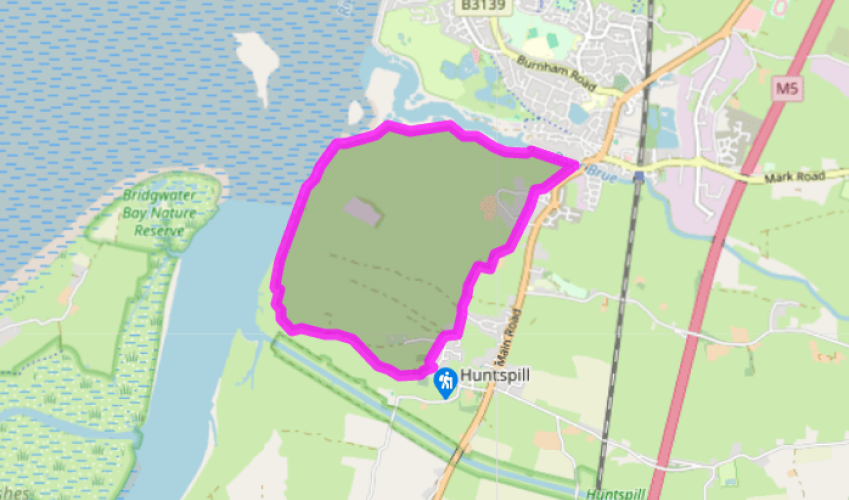
Head away from the church with houses on your right and trees on your left (with the sea behind them). The street, Church Road, bends right then back left: at the next bend keep ahead in Langlands Lane, which becomes hedged path between ditches. Join a concrete track and turn right to ugly Maundril's Farm.
Turn left on a waymarked footpath between huge sheds. Cross a track to an overgrown path ending at a stile, and turn half right to cross a field to a footbridge. A fenced path leads to a street and continues beyond it. It passes along the end of a second street, to reach a third.
Again a tarred path continues opposite, to emerge into a field. A fenced-off way runs round the edge of the field to an overgrown path ending at a gate. Continue along the right-hand edge of the field to its corner.
Here a short path leads out to the right: take this if you wish to cross the bridge to visit Highbridge. Opposite the burnt out Highbridge Inn is a memento of the former seaport: a handsome Victorian warehouse in brick and stone. (Toilets are found across the roundabout in a car park on the right.) The main walk continues along the field-edge near the River Brue, with its banks of brown mud, to reach the sea lock.
Bear left for 30yds (27m) to a stile, and follow a path on the flood bank alongside the tidal river. As the banking reaches the sea, a gate on the right leads on to the concrete top of more sea defences.
Follow what is in effect a concrete track along the shoreline for a mile (1.6km). Here the limestone blocks, broken up by the sea, have fairly easy-to-find fragments of large ammonites. Where the concrete disappears under grass bear left to a gatepost, and cross the earth barrier to reach a tarred lane. After 150yds (137m) this bends inland to a lay-by, with a stile on the left just beyond.
Cross the stile here, and head towards Huntspill church on a faint field path with a hedge and ditch on your left. Cross a footbridge on the left – here field boundaries are made of water sometimes backed up by a hedge. Turn right alongside the hedge and ditch to join a track. After 300yds (274m) watch out for a footbridge on the right. Turn left until blocked by a ditch, then turn right to find a narrow footbridge. Head straight towards the church, over stiles and a footbridge, to enter the churchyard through a kissing gate.
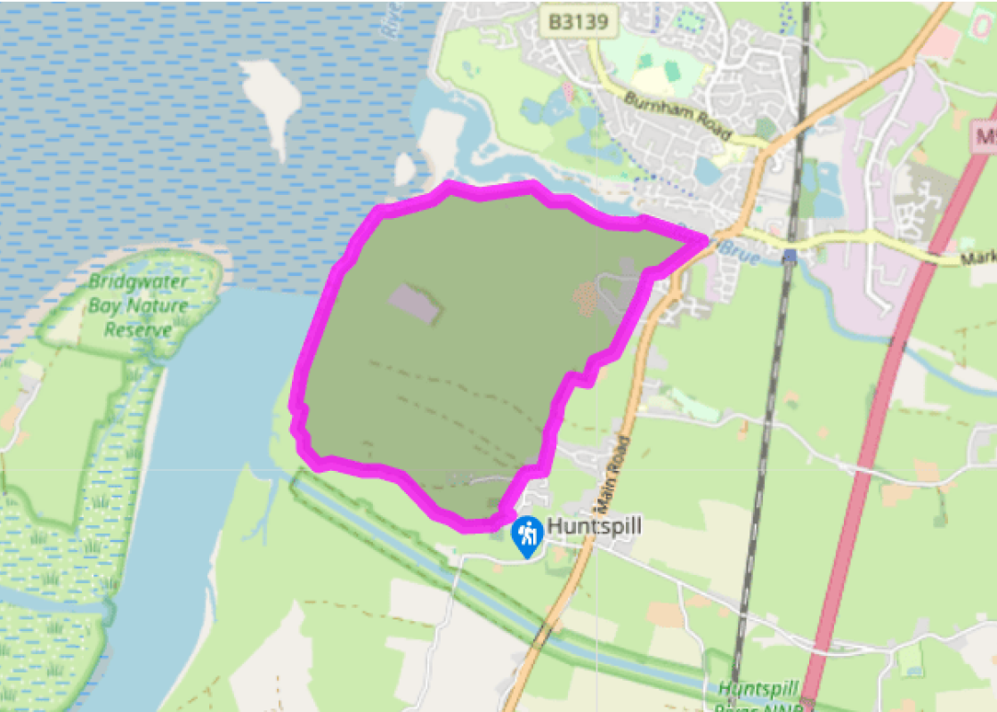
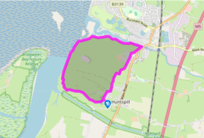
The walk's start point was formerly several miles out to sea, with the shoreline at the foot of the Polden Hills. Since the last Ice Age the tidal flow up and down the Bristol Channel has created the bank of clay mud on which you are now standing. Huntspill church, and the nearby houses, are built... on Plymor Hill. At just 2ft (60cm) high, this must be the lowest hill in the country; even so, during the floods of 1981, the people who live here were glad of the extra altitude. Managing mud Humans have drained the land behind this mud ridge to form the Somerset Levels and moors. The watercourses that drain all that fertile 'summer land' – the Kings Sedgemoor Drain, the Parrett itself – would also let the sea back in at every high tide, and so they must be closed off. We shall pass the barrier that closes the River Brue in the course of the walk. On the left you pass a concrete pill box, a coastal defence from World War II. On the other side, across the River Brue, you'll see a defence built against an enemy even more dangerous than the Germans: the sea itself. The Environment Agency, currently responsible for keeping the sea out of Britain, is coming to realise that such Canute-like and unsubtle ways of fighting the ocean are going to become less and less effective as global warming brings a rise in the sea, more autumn storms, and higher rainfall to swell the rivers behind. In November 2000 the Deputy Prime Minister, John Prescott, was very impressed by a Dutch system of overflow areas: deliberately letting floodwaters into certain areas for pumping out afterwards. 'Britain needs such a system' he declared – but in the Somerset Levels, Britain already has it. Hinkley Point On the other side of the estuary stands what is a striking focus for the rather flat landscape: the Hinkley Point nuclear power station. There is a certain irony in the fact that within its fence the power station harbours a small, but valuable, nature reserve protecting the home of 29 different types of butterfly and the rare bee orchid, and is a haven for the nightingale as well.
Somerset remains rural and unspoiled, and ever popular areas to visit are the limestone and red sandstone Mendip Hills rising to over 1,000 feet, and by complete contrast, to the south and southwest, the flat landscape of the Somerset Levels. Another popular spot, the Quantocks, once the haunt of poets Coleridge and Wordsworth, are noted for their gentle slopes, heather-covered moorland expanses and red deer.
"No cliffs or crashing waves – a coastal walk to heighten your understanding of flatlands and mud."
Walk details
1hr 45min
Difficulty:
Easy
Gradient:
Flat
Distance:
4.5 miles (7.2kms)
Ascent:
0ft (0m)
Walk directions
Head away from the church with houses on your right and trees on your left (with the sea behind them). The street, Church Road, bends right then back left: at the next bend keep ahead in Langlands Lane, which becomes hedged path between ditches. Join a concrete track and turn right to ugly Maundril's Farm.
1 of 7
Turn left on a waymarked footpath between huge sheds. Cross a track to an overgrown path ending at a stile, and turn half right to cross a field to a footbridge. A fenced path leads to a street and continues beyond it. It passes along the end of a second street, to reach a third.
2 of 7
Again a tarred path continues opposite, to emerge into a field. A fenced-off way runs round the edge of the field to an overgrown path ending at a gate. Continue along the right-hand edge of the field to its corner.
3 of 7
Here a short path leads out to the right: take this if you wish to cross the bridge to visit Highbridge. Opposite the burnt out Highbridge Inn is a memento of the former seaport: a handsome Victorian warehouse in brick and stone. (Toilets are found across the roundabout in a car park on the right.) The main walk continues along the field-edge near the River Brue, with its banks of brown mud, to reach the sea lock.
4 of 7
Bear left for 30yds (27m) to a stile, and follow a path on the flood bank alongside the tidal river. As the banking reaches the sea, a gate on the right leads on to the concrete top of more sea defences.
5 of 7
Follow what is in effect a concrete track along the shoreline for a mile (1.6km). Here the limestone blocks, broken up by the sea, have fairly easy-to-find fragments of large ammonites. Where the concrete disappears under grass bear left to a gatepost, and cross the earth barrier to reach a tarred lane. After 150yds (137m) this bends inland to a lay-by, with a stile on the left just beyond.
6 of 7
Cross the stile here, and head towards Huntspill church on a faint field path with a hedge and ditch on your left. Cross a footbridge on the left – here field boundaries are made of water sometimes backed up by a hedge. Turn right alongside the hedge and ditch to join a track. After 300yds (274m) watch out for a footbridge on the right. Turn left until blocked by a ditch, then turn right to find a narrow footbridge. Head straight towards the church, over stiles and a footbridge, to enter the churchyard through a kissing gate.
The walk's start point was formerly several miles out to sea, with the shoreline at the foot of the Polden Hills. Since the last Ice Age the tidal flow up and down the Bristol Channel has created the bank of clay mud on which you are now standing. Huntspill church, and the nearby houses, are built... on Plymor Hill. At just 2ft (60cm) high, this must be the lowest hill in the country; even so, during the floods of 1981, the people who live here were glad of the extra altitude. Managing mud Humans have drained the land behind this mud ridge to form the Somerset Levels and moors. The watercourses that drain all that fertile 'summer land' – the Kings Sedgemoor Drain, the Parrett itself – would also let the sea back in at every high tide, and so they must be closed off. We shall pass the barrier that closes the River Brue in the course of the walk. On the left you pass a concrete pill box, a coastal defence from World War II. On the other side, across the River Brue, you'll see a defence built against an enemy even more dangerous than the Germans: the sea itself. The Environment Agency, currently responsible for keeping the sea out of Britain, is coming to realise that such Canute-like and unsubtle ways of fighting the ocean are going to become less and less effective as global warming brings a rise in the sea, more autumn storms, and higher rainfall to swell the rivers behind. In November 2000 the Deputy Prime Minister, John Prescott, was very impressed by a Dutch system of overflow areas: deliberately letting floodwaters into certain areas for pumping out afterwards. 'Britain needs such a system' he declared – but in the Somerset Levels, Britain already has it. Hinkley Point On the other side of the estuary stands what is a striking focus for the rather flat landscape: the Hinkley Point nuclear power station. There is a certain irony in the fact that within its fence the power station harbours a small, but valuable, nature reserve protecting the home of 29 different types of butterfly and the rare bee orchid, and is a haven for the nightingale as well.
Somerset remains rural and unspoiled, and ever popular areas to visit are the limestone and red sandstone Mendip Hills rising to over 1,000 feet, and by complete contrast, to the south and southwest, the flat landscape of the Somerset Levels. Another popular spot, the Quantocks, once the haunt of poets Coleridge and Wordsworth, are noted for their gentle slopes, heather-covered moorland expanses and red deer.