"A landscape shaped by quarries and reservoirs, full of interest both historical and natural."
Walk directions
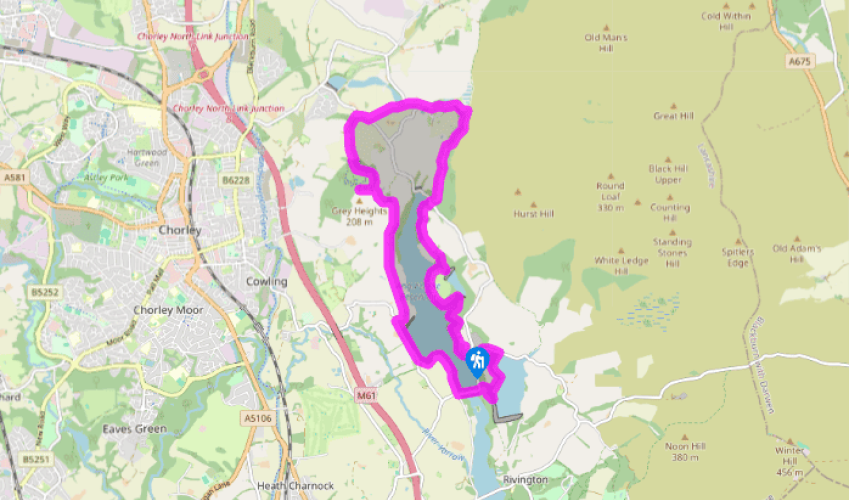
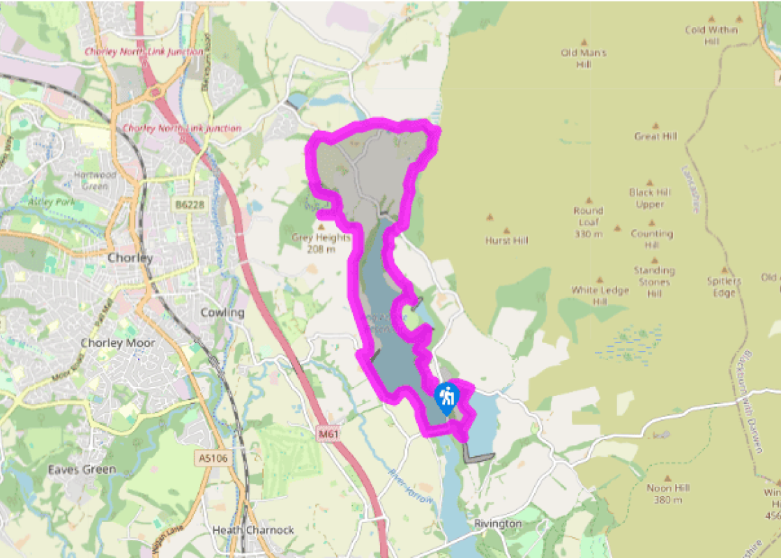
Leave beside the pay machine along a metalled path, keeping right to pass Lester Mill Quarry. Meeting a lakeside trail, go right staying with the main path as it climbs steeply towards High Bullough dam.
At a right-hand bend, take a path off left to contour above Anglezarke Reservoir. Later dropping to a track, go left. Cross a stream and climb to a kissing gate. Continue across sloping pasture. Ignore a footpath off right, in time entering more trees before emerging onto a lane.
Go briefly left before leaving through a kissing gate on the right. Stick with a broad path along the valley below Stronstrey Bank for 0.75 miles (1.2km), crossing a couple of footbridges before reaching a gate and bridge on the left over The Goit. Skirt left around White Coppice cricket green, passing the pavilion and car park onto a track.
To the left, becoming a lane, it leads through the hamlet. Bear right at a junction and go over a bridge to leave left by a letterbox over a footbridge. Follow the stream to a second footbridge then, passing a small reservoir, aim left to a stile. Carry on above a stream, later bearing across to a stile in the right field corner. Emerging onto a lane, go right to a sharp bend.
Take the track off left, signed to The Nab. Skirt buildings and keep ahead along a rising track to Nab Wood. Through a gate, fork left and stick with the main path. Approaching the edge of the wood, bear right to leave through a gate by an information board. Follow the boundary right to the next corner. Re-entering the wood, keep with the left wall to the high point, where to the left is a cairn marking the top of Grey Heights.
Retrace your steps down within the fringe of the wood. Exiting the corner, keep ahead to a cross path. Head right, soon curving down to a track.
Follow it right for 0.75 miles (1.2km). Where it swings abruptly right, walk ahead to Kays Farm.
Leave along its track to a lane and go left past an embankment. Entering trees, cross a stile on the left and skirt below the embankment before turning above the lakeshore. Later, after passing a walled wood, emerge onto a lane and head left across the Anglezarke dam. Leave through a gap on the bend beyond up a winding path to the Yarrow Reservoir. Go left, ultimately meeting another lane.
Turn left downhill, going right and first left at consecutive junctions back to the car park.
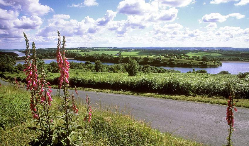
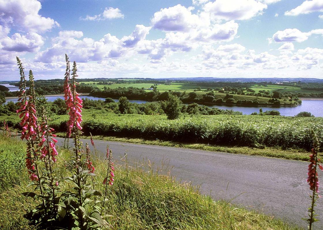
A string of reservoirs moats the western side of the high moors of Anglezarke and Rivington and quarries scar their flanks. This is not a pristine landscape by any stretch of the imagination, yet today it is seen by many as an oasis of tranquillity close to busy towns and a motorway. Reclaimed by... nature A gentle start just above the shores of Anglezarke Reservoir leads to Lester Mill Quarry, which was worked until the 1930s. The quarry wall is imposing, but somewhat vegetated, and the rock is loose in places. It is much less popular with climbers than Anglezarke Quarry. The name is one reminder that this valley was once a thriving agricultural community. The mill, which served the whole valley, was drowned by the reservoir in 1855. Cheap imports further weakened the rural economy. Today there is only one working farm east of the reservoir. The route continues through a mix of woodland and pasture to the head of the water, then heads up the valley below steep, bouldery Stronstrey Bank. There's another quarry high on the right near the end of the bank, seemingly guarded by a number of gaunt, dead trees. Further on is another, set further back. Just beyond this an impressive spillway testifies to the potential power of Dean Black Brook. Busy industrial village Now you cross The Goit, a canal that feeds the reservoir, to White Coppice cricket ground. There's a small reservoir just above and you pass others on the way down to the present-day hamlet. These served a cotton mill that flourished here for well over a century. Along with the quarries at Stronstrey Bank these made White Coppice a busy industrial village with a population which may have approached 200. The mill closed in 1914 and little remains today. The railway closed in the late 1950s, the school in 1963 and the church in 1984. This sounds like a story of decline yet today many people would see White Coppice as an idyllic place to live, a fact reflected in the local house prices. View to Winter Hill After White Coppice you climb to Healey Nab, which conceals more quarries. Trees obscure what must have been a fine all-round view from the highest point, but there's a good southward prospect from the large cairn on Grey Heights. Winter Hill is the highest of the moors, unmistakable with its TV towers. The main mast is just over 1,000ft (305m) tall, so you could argue that its tip is the highest point in Lancashire. The string of reservoirs is also well displayed and you get a bird's eye view of Chorley. The walk finishes across the Anglezarke dam and then, to minimise road walking, makes a short climb to the small Yarrow Reservoir. The final descent gives an opportunity to look into Anglezarke Quarry.
Lancashire was at the centre of the British cotton industry in the 19th century, which lead to the urbanization of great tracts of the area. The cotton boom came and went, but the industrial profile remains.
"A landscape shaped by quarries and reservoirs, full of interest both historical and natural."
Walk details
3hrs
Difficulty:
Medium
Gradient:
Moderate
Distance:
7.5 miles (12.1kms)
Ascent:
885ft (270m)
Walk directions
Leave beside the pay machine along a metalled path, keeping right to pass Lester Mill Quarry. Meeting a lakeside trail, go right staying with the main path as it climbs steeply towards High Bullough dam.
1 of 9
At a right-hand bend, take a path off left to contour above Anglezarke Reservoir. Later dropping to a track, go left. Cross a stream and climb to a kissing gate. Continue across sloping pasture. Ignore a footpath off right, in time entering more trees before emerging onto a lane.
2 of 9
Go briefly left before leaving through a kissing gate on the right. Stick with a broad path along the valley below Stronstrey Bank for 0.75 miles (1.2km), crossing a couple of footbridges before reaching a gate and bridge on the left over The Goit. Skirt left around White Coppice cricket green, passing the pavilion and car park onto a track.
3 of 9
To the left, becoming a lane, it leads through the hamlet. Bear right at a junction and go over a bridge to leave left by a letterbox over a footbridge. Follow the stream to a second footbridge then, passing a small reservoir, aim left to a stile. Carry on above a stream, later bearing across to a stile in the right field corner. Emerging onto a lane, go right to a sharp bend.
4 of 9
Take the track off left, signed to The Nab. Skirt buildings and keep ahead along a rising track to Nab Wood. Through a gate, fork left and stick with the main path. Approaching the edge of the wood, bear right to leave through a gate by an information board. Follow the boundary right to the next corner. Re-entering the wood, keep with the left wall to the high point, where to the left is a cairn marking the top of Grey Heights.
5 of 9
Retrace your steps down within the fringe of the wood. Exiting the corner, keep ahead to a cross path. Head right, soon curving down to a track.
6 of 9
Follow it right for 0.75 miles (1.2km). Where it swings abruptly right, walk ahead to Kays Farm.
7 of 9
Leave along its track to a lane and go left past an embankment. Entering trees, cross a stile on the left and skirt below the embankment before turning above the lakeshore. Later, after passing a walled wood, emerge onto a lane and head left across the Anglezarke dam. Leave through a gap on the bend beyond up a winding path to the Yarrow Reservoir. Go left, ultimately meeting another lane.
8 of 9
Turn left downhill, going right and first left at consecutive junctions back to the car park.
A string of reservoirs moats the western side of the high moors of Anglezarke and Rivington and quarries scar their flanks. This is not a pristine landscape by any stretch of the imagination, yet today it is seen by many as an oasis of tranquillity close to busy towns and a motorway. Reclaimed by... nature A gentle start just above the shores of Anglezarke Reservoir leads to Lester Mill Quarry, which was worked until the 1930s. The quarry wall is imposing, but somewhat vegetated, and the rock is loose in places. It is much less popular with climbers than Anglezarke Quarry. The name is one reminder that this valley was once a thriving agricultural community. The mill, which served the whole valley, was drowned by the reservoir in 1855. Cheap imports further weakened the rural economy. Today there is only one working farm east of the reservoir. The route continues through a mix of woodland and pasture to the head of the water, then heads up the valley below steep, bouldery Stronstrey Bank. There's another quarry high on the right near the end of the bank, seemingly guarded by a number of gaunt, dead trees. Further on is another, set further back. Just beyond this an impressive spillway testifies to the potential power of Dean Black Brook. Busy industrial village Now you cross The Goit, a canal that feeds the reservoir, to White Coppice cricket ground. There's a small reservoir just above and you pass others on the way down to the present-day hamlet. These served a cotton mill that flourished here for well over a century. Along with the quarries at Stronstrey Bank these made White Coppice a busy industrial village with a population which may have approached 200. The mill closed in 1914 and little remains today. The railway closed in the late 1950s, the school in 1963 and the church in 1984. This sounds like a story of decline yet today many people would see White Coppice as an idyllic place to live, a fact reflected in the local house prices. View to Winter Hill After White Coppice you climb to Healey Nab, which conceals more quarries. Trees obscure what must have been a fine all-round view from the highest point, but there's a good southward prospect from the large cairn on Grey Heights. Winter Hill is the highest of the moors, unmistakable with its TV towers. The main mast is just over 1,000ft (305m) tall, so you could argue that its tip is the highest point in Lancashire. The string of reservoirs is also well displayed and you get a bird's eye view of Chorley. The walk finishes across the Anglezarke dam and then, to minimise road walking, makes a short climb to the small Yarrow Reservoir. The final descent gives an opportunity to look into Anglezarke Quarry.
Lancashire was at the centre of the British cotton industry in the 19th century, which lead to the urbanization of great tracts of the area. The cotton boom came and went, but the industrial profile remains.