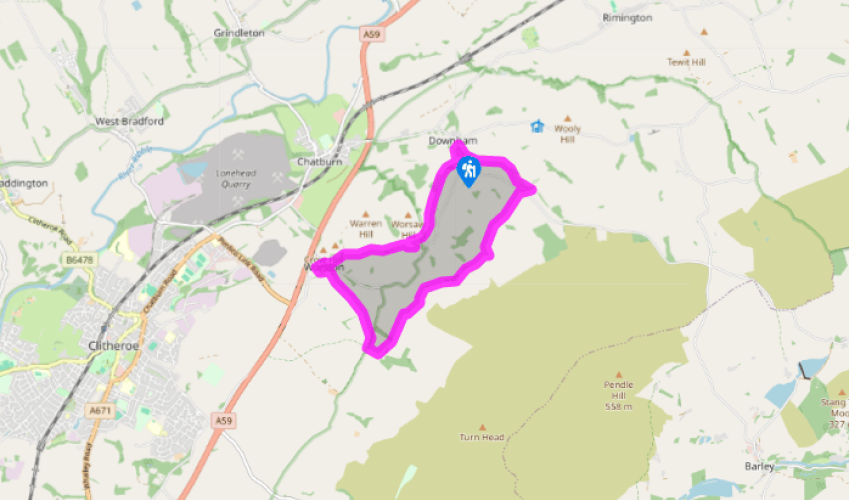
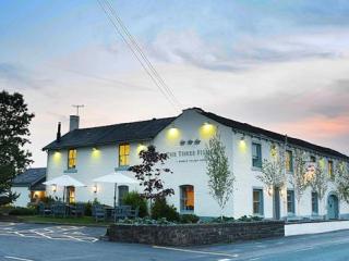
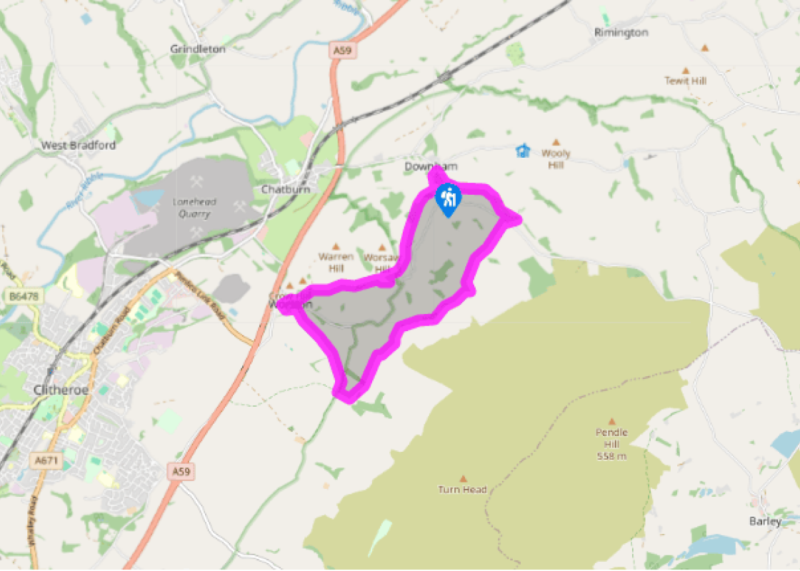
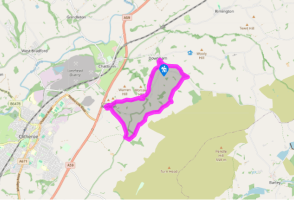
From the car park entrance, turn right along a waymarked track. Continue with the ongoing trod across successive fields for 0.75 miles (1.2km), eventually skirting Worsaw Hill. Where the path splits above Worsaw End House, stay beside the wall to a gate near the corner. Cut right to a second gate and carry on at the bottom of two more fields. Emerging onto a track, go left to a lane and turn right into Worston.
Beyond The Calf's Head, go first left between cottages. Keep ahead to a footbridge and turn left beside Worston Brook. Approaching the second house, turn sharp right across a gravel yard to a gate. Walk upfield to a stile beyond an indented corner and continue in the next field. Through a small gate near the far-right corner, carry on beside a fence towards Little Mearley Hall.
Meeting a track, go right, shortly turning left to the farm. Entering the yard, swing left between barns, leaving at the far end with a wall on your left. Through a gate, bear left to a water trough and continue at the edge of the next field. In the corner go right and then left over stiles and carry on to Angram Green. Bear right across a stream into another field and head to the far-left corner. Emerging onto a lane, follow it right to Moorside Farm.
Through the yard, exit between barns at the top right corner. Over a stream, bear left above Barkerfield to join a rough track leading on to Hookcliffe Farm. As you approach, leave through a gate on the right to skirt the buildings. Just beyond, through a kissing gate on the left, head downfield then swing right along the bottom boundary, continuing across more fields to Gerna. There, climb a stile behind the barn and follow a track out to a lane.
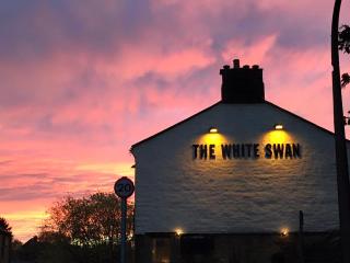
Go right but then take the first track off left towards Clay House. After 100yds (91m), look for a kissing gate on the left. A path leads away, continuing at the edge of the fields beyond and following the beck back to Downham. Emerging at the bottom past cottages, cross the stream and keep ahead up the hill into the village. A lane on the left leads back to the car park while The Assheton Arms stands opposite St Leonard's Church at the top of the hill.
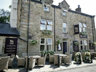
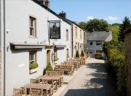
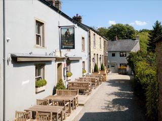
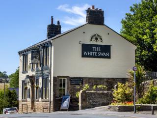
There may well be other contenders, but Downham is hard to beat as Lancashire's prettiest village. Yet it's not just the absence of yellow lines, dangling wires or the clutter of aerials that make it special. Wander through and you can sense the pride that everyone who lives here takes in their... village; for it is theirs, despite the fact that it remains in the ownership of the lord of the manor, Lord Clitheroe, whose family, the Asshetons, have lived at Downham Hall since 1558. Their name appears on the signboard of the 18th-century inn, which stands at the top of the village opposite St Leonard's Church. Lower down, the main street is lined with a picturesque assortment of cottages and other buildings, the oldest of which goes back almost as long as the Asshetons. But the settlement is far older and was established well before the arrival of the Normans. The Roman road from Ribchester to Ilkley ran just north of the village, connecting with a much older track that led out to the coast. A vision and witch trials Downham occupies a spur of ground overlooking the fold of Downham Brook to the rising bulk of Pendle. It was to there, in 1652, that George Fox, the founder of the Quakers, was drawn to receive a vision of souls coming to Christ, only 40 years after the infamous trials of the Pendle witches, at which 10 were found guilty and subsequently hanged. Alice Nutter, one of the unfortunates, came from nearby Roughlee, but supposedly hid in Downham Old Hall before her capture. The timeless beauty of the village has inevitably made it a filming location for period dramas, including the 1961 film Whistle Down the Wind and the BBC television series Born and Bred, which appeared between 2002 and 2005. Worston Just beyond the prominence of Worsaw Hill, the site of a prehistoric burial ground, its neighbour Worston is also a delight. At its heart is The Calf's Head, which despite its 'modern' Victorian building claims a history going back more than 400 years. Like many other old pubs, it started life as a farm, which was still working into the 1950s. Worston too lay close beside the Roman road and, in 1778, road-workers discovered a cache of silver Roman coins buried there.
Lancashire was at the centre of the British cotton industry in the 19th century, which lead to the urbanization of great tracts of the area. The cotton boom came and went, but the industrial profile remains.
From the car park entrance, turn right along a waymarked track. Continue with the ongoing trod across successive fields for 0.75 miles (1.2km), eventually skirting Worsaw Hill. Where the path splits above Worsaw End House, stay beside the wall to a gate near the corner. Cut right to a second gate and carry on at the bottom of two more fields. Emerging onto a track, go left to a lane and turn right into Worston.
1 of 5
Beyond The Calf's Head, go first left between cottages. Keep ahead to a footbridge and turn left beside Worston Brook. Approaching the second house, turn sharp right across a gravel yard to a gate. Walk upfield to a stile beyond an indented corner and continue in the next field. Through a small gate near the far-right corner, carry on beside a fence towards Little Mearley Hall.
2 of 5
Meeting a track, go right, shortly turning left to the farm. Entering the yard, swing left between barns, leaving at the far end with a wall on your left. Through a gate, bear left to a water trough and continue at the edge of the next field. In the corner go right and then left over stiles and carry on to Angram Green. Bear right across a stream into another field and head to the far-left corner. Emerging onto a lane, follow it right to Moorside Farm.
3 of 5
Through the yard, exit between barns at the top right corner. Over a stream, bear left above Barkerfield to join a rough track leading on to Hookcliffe Farm. As you approach, leave through a gate on the right to skirt the buildings. Just beyond, through a kissing gate on the left, head downfield then swing right along the bottom boundary, continuing across more fields to Gerna. There, climb a stile behind the barn and follow a track out to a lane.
4 of 5
Go right but then take the first track off left towards Clay House. After 100yds (91m), look for a kissing gate on the left. A path leads away, continuing at the edge of the fields beyond and following the beck back to Downham. Emerging at the bottom past cottages, cross the stream and keep ahead up the hill into the village. A lane on the left leads back to the car park while The Assheton Arms stands opposite St Leonard's Church at the top of the hill.
There may well be other contenders, but Downham is hard to beat as Lancashire's prettiest village. Yet it's not just the absence of yellow lines, dangling wires or the clutter of aerials that make it special. Wander through and you can sense the pride that everyone who lives here takes in their... village; for it is theirs, despite the fact that it remains in the ownership of the lord of the manor, Lord Clitheroe, whose family, the Asshetons, have lived at Downham Hall since 1558. Their name appears on the signboard of the 18th-century inn, which stands at the top of the village opposite St Leonard's Church. Lower down, the main street is lined with a picturesque assortment of cottages and other buildings, the oldest of which goes back almost as long as the Asshetons. But the settlement is far older and was established well before the arrival of the Normans. The Roman road from Ribchester to Ilkley ran just north of the village, connecting with a much older track that led out to the coast. A vision and witch trials Downham occupies a spur of ground overlooking the fold of Downham Brook to the rising bulk of Pendle. It was to there, in 1652, that George Fox, the founder of the Quakers, was drawn to receive a vision of souls coming to Christ, only 40 years after the infamous trials of the Pendle witches, at which 10 were found guilty and subsequently hanged. Alice Nutter, one of the unfortunates, came from nearby Roughlee, but supposedly hid in Downham Old Hall before her capture. The timeless beauty of the village has inevitably made it a filming location for period dramas, including the 1961 film Whistle Down the Wind and the BBC television series Born and Bred, which appeared between 2002 and 2005. Worston Just beyond the prominence of Worsaw Hill, the site of a prehistoric burial ground, its neighbour Worston is also a delight. At its heart is The Calf's Head, which despite its 'modern' Victorian building claims a history going back more than 400 years. Like many other old pubs, it started life as a farm, which was still working into the 1950s. Worston too lay close beside the Roman road and, in 1778, road-workers discovered a cache of silver Roman coins buried there.
Lancashire was at the centre of the British cotton industry in the 19th century, which lead to the urbanization of great tracts of the area. The cotton boom came and went, but the industrial profile remains.