An ancient watchtower

Climb out of the Douglas Valley for views across the Lancashire Plain and beyond

NEAREST LOCATION

Ashurst's Beacon

RECOMMENDED BY
DISTANCE

8 miles (12.9kms)

ASCENT
689ft (210m)
TIME
3hrs
GRADIENT
DIFFICULTY
Easy
STARTING POINT
SD517072

About the walk

Despite proximity to the Wigan and Skelmersdale conurbations, the Douglas Valley below Dalton is an attractive landscape of chequered fields, copses and steep-sided cloughs draining the hill.

Past industry

Roby Mill grew around an Elizabethan manorial corn mill that operated until the 19th century. A sizeable complex, it incorporated drying and malting kilns, fish pools and a small farm. But despite a rural appearance, the valley had a surprisingly industrial past. There was a tannery at Roby Mill and small cottage industries such as nail making and weaving flourished, while from the 18th century coal and slate became important products.

The stimulus was the waterway. To the east, Wigan lay upon rich coal deposits, vital to the Industrial Revolution, but transport was crucial. In 1742 work began on making the River Douglas navigable from the Ribble Estuary up to Wigan. The western section of the Leeds and Liverpool Canal soon followed, enabling coal to be delivered directly to the Liverpool docks.

19th-century boom

Although not fully completed until 1816, trade quickly developed along the canal. At Appley Bridge and Gathurst, the original single deep locks were augmented with pairs of shallower locks, controlled by lock keepers from their cottages. Pubs and stables appeared too, servicing both the bargees and their horses. The Baby Elephant at Gathurst was just such a one and used to be called The Navigation.

The canal brought new industries; just downstream at Parbold there were boat builders and chandlers, while at Gathurst in 1888, Roburite established an explosives factory. It originally manufactured explosives for the coal mines, but during World War II production turned to munitions and more than 500 people were employed.

Ashurst's Beacon

The summit of the walk is Ashurst's Beacon, which, although not particularly high, commands a far-reaching view that extends from the distant Snowdonia mountains to those of the Lake District, while behind is Winter Hill on the western fringe of the Pennines. The present tower was constructed in 1798 in response to Napoleon's threats and replaced a 16th-century beacon built to warn of a Spanish invasion. Both were put up by the Ashursts, a prominent local family whose seat lay at the foot of the hill by Dalton church.

Walk directions

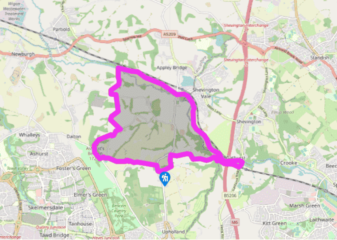
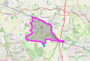
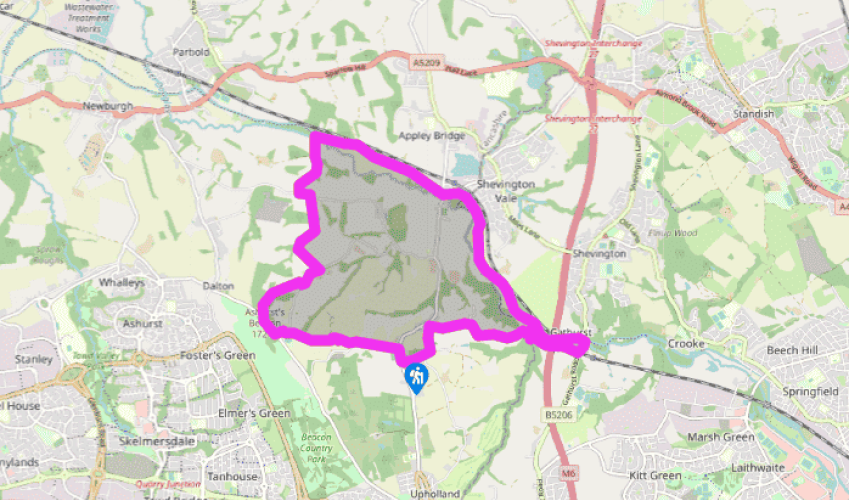
Turn left from the car park and left again up Farley Lane.

After 600yds (549m), on a bend, leave the path, going ahead along a farm track. Beyond a cottage, keep ahead to a T-junction and go left. Almost immediately, turn off right by a telegraph post and walk uphill with a hedge on your left. Beyond the crest, slip through a gap and continue with the boundary on your right. Over a stile, walk past a cricket green to a lane. Follow it left to the main road by the Prince William. Go right past a second pub, The Beacon, forking right just after on rising path to Ashurst's Beacon.

At a topograph beyond the tower, bear right through trees to a stile. Descend across open ground and then beside a wooded dell. Over a footbridge, carry on above the other bank before swinging right to a lane. Head downhill past cottages for 0.25 miles (400m) before abandoning it along a track on the left. Later, swinging right, continue beside a deep dell. Lower down the path, fork right, shortly emerging onto Lees Lane.

Turn left for 200yds (182m), then leave right on a track beside a house. Fork right behind the buildings, in time descending more steeply beside trees. Over a stile at the bottom, bear right to a second stile, shortly afterwards crossing the River Douglas to the Leeds and Liverpool Canal.

Follow the towpath right to Appley Bridge and continue for another 1.5 miles (2.4km), passing beneath the M6 and a railway before leaving beside bridge 46 at Gathurst.

Turn right across the River Douglas and beneath the railway, before taking a gated track on the right. Passing back beneath the motorway, the track leads to a footbridge spanning Dean Brook.

Go right to the River Douglas, then swing left in front of a field gate. Keep with the fence around a corner to a stile. Climb away beside a line of trees, later curving right with a low bank to a kissing gate. The ongoing path bends left and over a stile onto a track by Ayrefield House. Follow it left, later passing terraced houses.

Where the street bends right to the main road, leave along a contained passage beside the end terrace. Continue by fields, cross a stream, and keep ahead through thicket to emerge at Walthew Green. Go right and keep left at a fork, climbing to the main road at Roby Mill beside Fifteen's @ The Fox. The car park is just to the right.

Additional information

Field paths and canal towpath, 8 stiles

Rolling farmed countryside overlooking the Douglas Valley

Under control and on leads near roads and grazing stock

OS Explorer 285 Southport & Chorley

Car park at Roby Mill

None on route

Been on this walk?

Send us photos or a comment about this route.

Know a good walk?

Share your route with us.

WALKING IN SAFETY

Read our tips to look after yourself and the environment when following this walk.

Find out more

About the area

Discover Lancashire

Lancashire was at the centre of the British cotton industry in the 19th century, which lead to the urbanization of great tracts of the area. The cotton boom came and went, but the industrial profile remains. Lancashire’s resorts, Blackpool, Southport and Morecambe Bay, were originally developed to meet the leisure needs of the cotton mill town workers. Blackpool is the biggest and brashest, celebrated for it tower, miles of promenade, and the coloured light ‘illuminations’. Amusements are taken very seriously here, day and night, and visitors can be entertained in a thousand different ways.

The former county town, Lancaster, boasts one of the younger English universities, dating from 1964. Other towns built up to accommodate the mill-workers with back-to-back terraced houses, are Burnley, Blackburn, Rochdale and Accrington. To get out of town, you can head for the Pennines, the ‘backbone of England’, a series of hills stretching from the Peak District National Park to the Scottish borders. To the north of the country is the Forest of Bowland, which despite its name is fairly open country, high up, with great views.

Why choose Rated Trips?

Your trusted guide to rated places across the UK
icon example
The best coverage

Discover more than 15,000 professionally rated places to stay, eat and visit from across the UK and Ireland.

icon example
Quality assured

Choose a place to stay safe in the knowledge that it has been expertly assessed by trained assessors.

icon example
Plan your next trip

Search by location or the type of place you're visiting to find your next ideal holiday experience.

icon example
Travel inspiration

Read our articles, city guides and recommended things to do for inspiration. We're here to help you explore the UK.