Around Cadbury Castle

A hill-fort gives wide views of Somerset and a glimpse of pre-history.

NEAREST LOCATION

South Cadbury

RECOMMENDED BY
DISTANCE

6.5 miles (10.4kms)

ASCENT
1000ft (305m)
TIME
3hrs 30min
GRADIENT
DIFFICULTY
Medium
STARTING POINT
ST632253

About the walk

Cadbury Castle was a military stronghold for over 4,000 years. The ditches and earth walls first rose in the Stone Age, and were extended in the Bronze Age. In the Iron Age it became the capital of the Durotinges tribe, who gave their name to Dorset. Here they built a town of wood, willow-wattle and thatch and held out against the Romans. The Romans won in the end: they burnt down the hilltop town in around AD 70. The Saxon, Ethelred the Unready, repaired the fort against the Vikings. Again it became a wartime capital, replacing Ilchester between 1009 and 1019. Coins were minted here, and labelled 'CADANBYRIC'.

The local belief that Cadbury is indeed King Arthur's Camelot was first recorded in 1542 – more than 1,000 years after King Arthur. However, it was supported by excavations in the 1960s, which showed that, at the very time of the legendary King Arthur, the walls were rebuilt in timber and stone. Some of this stonework is visible on the left as you return to the track down off the hill. A large and kingly timber hall rose on the hilltop. Finds of pottery imported from the eastern Mediterranean indicate a place of wealth and good taste. In this wooden hall the various strands of legend converge. We can imagine rich tapestries hanging from the panelled walls, and below them the court intrigues and amours, described by the 15th-century Sir Thomas Malory. It's even easier to see Queen Guenevere and her ladies riding out along Corton Ridge to gather may-blossom.

But at the end of a short mid-winter's day, in the darkness under the trees, the pre-Christian, hollybearing Green Knight of the anonymous Gawain Poet comes striding up the long earthen ramp. And if he did exist, it was very possibly from here that Arthur and his knights went forth to the battle of Mons Badonis, which may have been at Bath, to conquer the Saxon; and later to defeat at the bloody battle of Camlann. Like most of the limestone hillocks of Somerset that made such fine forts, Cadbury has a wide view over the Levels. The viewpoint cairn was raised at the Millennium; in accordance with the Arthurian environment, the places indicated are mostly mystic and invisible. The eye of faith and legend sees behind the horizon to Stonehenge, Avebury and Tintagel. But in winter, the actual eye can trace the possible route of Arthur's final journey, through the flooded fields of the Somerset Levels. Legend would have it that three queens in a black barge carried him through the high water to Glastonbury, on Avalon Isle, knowing his wound was a deadly one. And there he supposedly rests, hidden in the hill, waiting to be called to defend Britain in her hour of need.

Walk directions

Turn right out of the car park to the first house in South Cadbury. A stony track leads up to Cadbury Castle. The earth ramparts and top of the fort are Access Land, so you can stroll around at will.

Return past the car park. After 0.25 miles (400m) you pass the end of Crangs Lane on the left; 60yds (55m) later, cross a stile. Go straight down to a stile and footbridge. Follow the left edge of a field then keep ahead across it. A track runs ahead, but take a stile on the right to follow the field-edge next to it, then a line of hawthorns ahead, to a gate with two waymarkers. A faint track leads along the top of the following field. At the field's end turn down into a hedged earth track. This leads out past Whitcombe Farm to rejoin the road.

Turn left to a junction below Corton Denham Beacon. Between the two roads, take a gate onto the very steep spur of Corton Hill, and go up it (or more gently slant up left above trees), to the summit trig point.

Head along the hill rim with steep drops to Corton Denham on the right and soon with a fence on the left. You pass a modern 'tumulus', a small, covered reservoir. Above five large lime trees slant gently down to a small, waymarked gate. A green path slants down again, until a gate lets you on to a tarred lane; follow this until you reach the road below.

Turn left on the road, which is narrow between high banks, for 170yds (155m) to a stile on the right, beside a field gate. Go straight down the field, left of a tree and ditch line, to a hidden stile into a lane. Keep ahead on a stony (but muddy when tractors have been using it) track that climbs gently to the ridgeline.

Turn right, and walk along Corton Ridge with a hedge on the right and a wide view on the left. After 650yds (594m) Ridge Lane starts on the right, but go through a small gate on the left to continue along the ridge. After a final gate a green path bends around the flank of Parrock Hill. With Cadbury Castle now on the left, the main path bears down left to a hedge corner and waymarked gate. A hedged path leads to a road.

Cross into a road signed 'South Cadbury'. After 700yds (640m) turn right, again towards South Cadbury, and follow the road round to the right of Cadbury Castle to the car park.

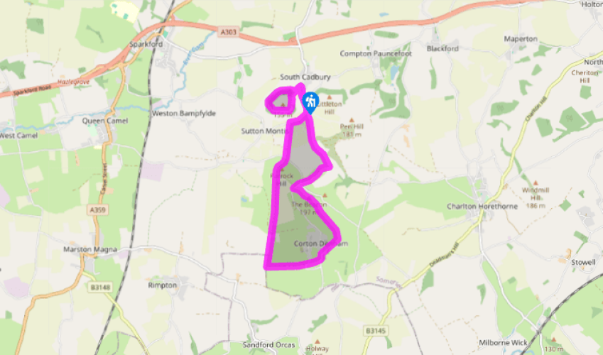
Additional information
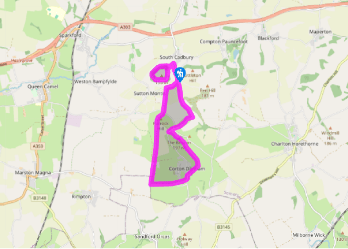
Well-used paths, several stiles

Steep-sided, green hills

Mixed farming: reasonable freedom

OS Explorer 129 Yeovil & Sherborne

Cadbury Castle car park (free), south of South Cadbury

None on route

Been on this walk?

Send us photos or a comment about this route.

Know a good walk?

Share your route with us.

WALKING IN SAFETY

Read our tips to look after yourself and the environment when following this walk.

Find out more

About the area

Discover Somerset

Somerset means ‘summer pastures’ – appropriate given that so much of this county remains rural and unspoiled. Ever popular areas to visit are the limestone and red sandstone Mendip Hills rising to over 1,000 feet, and by complete contrast, to the south and southwest, the flat landscape of the Somerset Levels. Descend to the Somerset Levels, an evocative lowland landscape that was the setting for the Battle of Sedgemoor in 1685. In the depths of winter this is a desolate place and famously prone to extensive flooding. There is also a palpable sense of the distant past among these fields and scattered communities. It is claimed that Alfred the Great retreated here after his defeat by the Danes.

Away from the flat country are the Quantocks, once the haunt of poets Samuel Taylor Coleridge and William Wordsworth. The Quantocks are noted for their gentle slopes, heather-covered moorland expanses and red deer. From the summit, the Bristol Channel is visible where it meets the Severn Estuary. So much of this hilly landscape has a timeless quality about it and large areas have hardly changed since Coleridge and Wordsworth’s day.

Why choose Rated Trips?

Your trusted guide to rated places across the UK
icon example
The best coverage

Discover more than 15,000 professionally rated places to stay, eat and visit from across the UK and Ireland.

icon example
Quality assured

Choose a place to stay safe in the knowledge that it has been expertly assessed by trained assessors.

icon example
Plan your next trip

Search by location or the type of place you're visiting to find your next ideal holiday experience.

icon example
Travel inspiration

Read our articles, city guides and recommended things to do for inspiration. We're here to help you explore the UK.