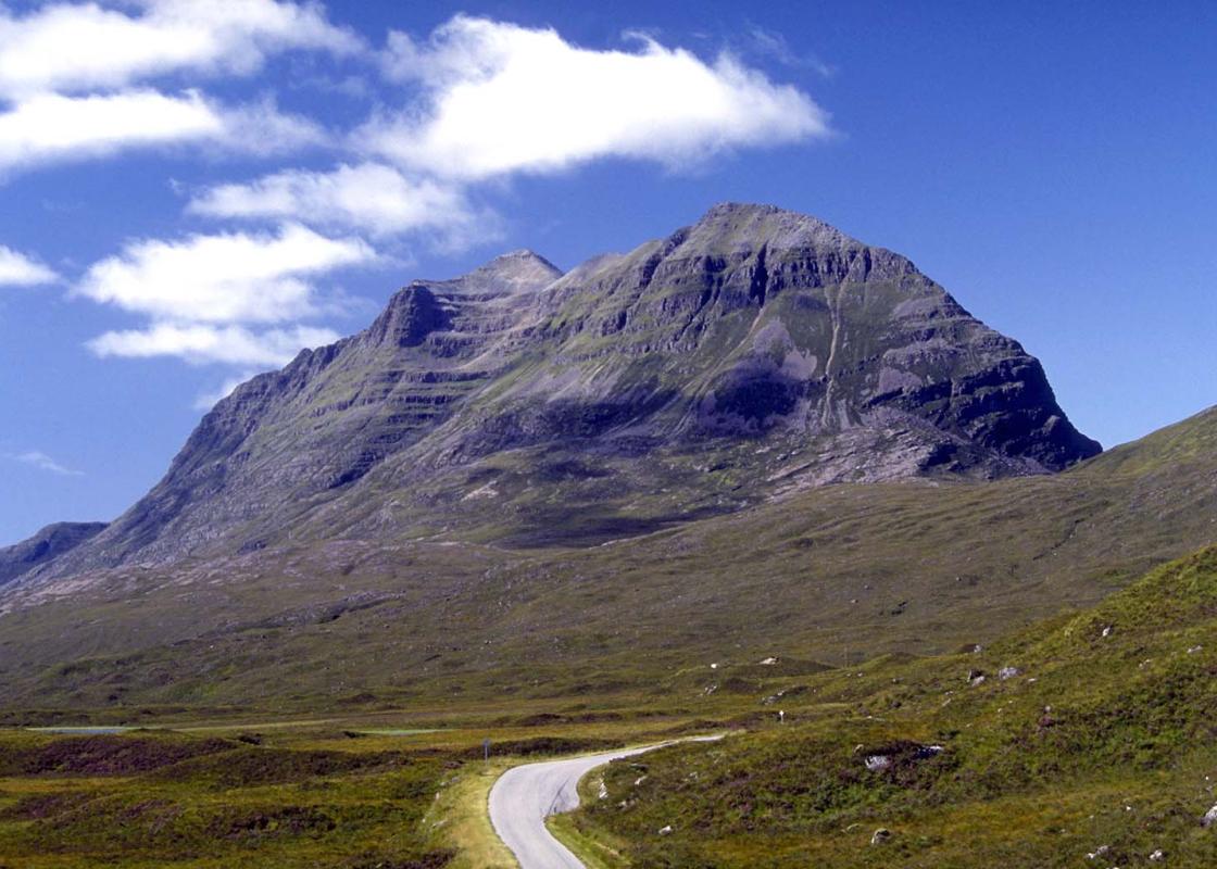
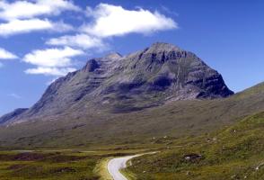
"The toughest waymarked trail in Scotland, to a lunar landscape."
Walk directions
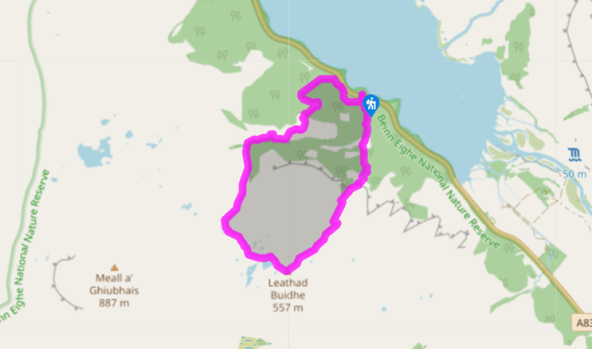
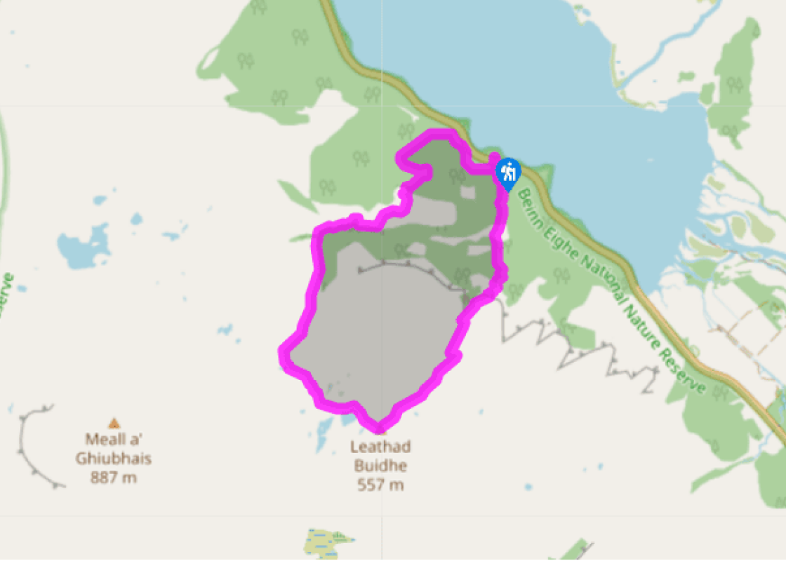
The route is well marked. Look out for cairns, and in the steeper sections, rough rock steps forming the path. From the end of the car park, turn left to pass under the road; immediately turn left again, following a sign for the Mountain Trail. The path goes under birches, with a stream on its right, then under pines. It then climbs slightly more steeply, across slabs of reddish sandstone, to the marker cairn named ‘Pines’. The path then climbs steeply up rough stone steps to a footbridge.
The path continues up more steps, now with the stream on its right. The ascent is very steep, but there are plenty of named cairns to stop at and read the trail booklet! The cairn 'Geology' is followed by Trumpet Rock. The cairn called ‘305m’ indicates the 1,000ft mark. Above, you can see how the quartzite, originally laid in flat layers on a seabed, now dips fairly steeply towards Loch Maree. The path passes along the base of a crag, then turns up left to a cairn called ‘Heather’. The path now ascends less steeply, over stony ground, to the walk's high point at the Conservation Cairn.
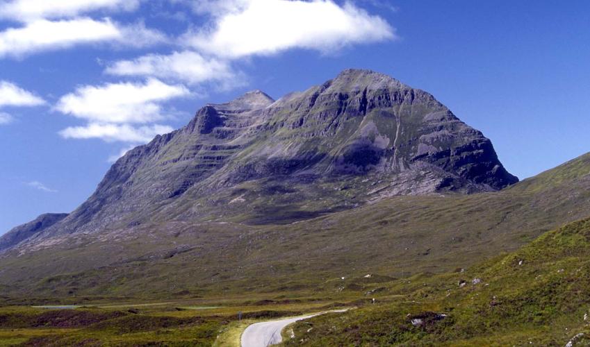
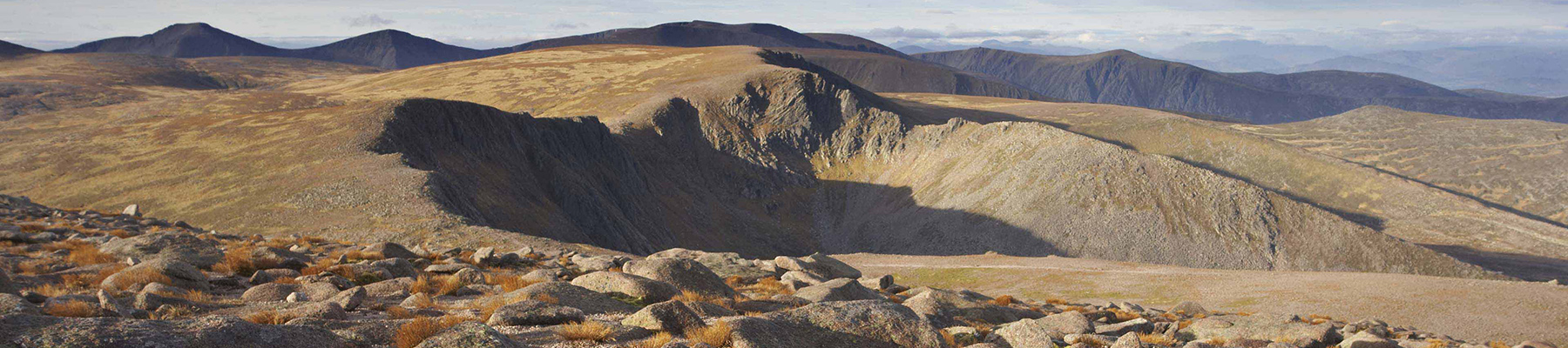
The cairn has a fine view up to Beinn Eighe. The rotten quartzite pinnacles, called the Black Carls, are seen more clearly from Kinlochewe. Their serrated outline gives the mountain its name, the Hill of the File. At the cairn the path turns right into a hummocky landscape of rocks and gravel – very much as the glaciers left it. Straight after leaving the Conservation Cairn you go down steep stone steps to pass a lochan, then reach another called Lunar Loch.
The path now heads downhill – the descent not quite so steep as the climb. The way descends to the left of the deep ravine of the Allt na h-Airighe. The path climbs a few steps to a knoll with a fine view along Loch Maree, with the Fossil Cairn just below this point. The path follows the gorge brink (well fenced), then bends down left. At the cairn called ‘Ice Age’, quartzite slabs show the scratches of the glacier that moved down the valley towards the left. The marks show most clearly on the fresh surface exposed by feet.
Back in the forest, turn left at a path junction where the Woodland Trail rejoins. Soon, a short side-path on the right leads to a view point cairn built in layers of quartzite, sandstone and gneiss. The path drops through the sheltering trees to run quite close to the road below. At a junction, turn down left under the road by the bridge of the outward walk.
Beinn Eighe is Britain’s oldest National Nature Reserve (1951) and the Mountain Trail is possibly Scotland’s toughest nature trail. The relentless ascent to the 1,800ft (548m) level takes you from luxuriant pine forest up to a mountain zone of bare stones and wind-chilled lochans. Pine times ... Scots pines once clothed all the valley sides of Wester Ross. The ones around Loch Maree were fed into the fires of an iron works directly opposite and the furnaces at Bonawe near Oban. More recently, ancient pines were felled to make ammunition boxes during World War II. Genetic analysis has shown that the pines here are related to those of France and Spain, whereas those in the Cairngorms and eastern Scotland spread after the Ice Age from northern Europe. Rocks of Ross In the path and under the small waterfalls, you’ll see that the bedrock changes from rounded red sandstone to angular pale-grey quartzite. From the cairn called ‘Geology’ you can see all three of the distinctive rocks of Wester Ross. Quartzite is underfoot. Across Loch Maree, the steep-sided stack of Slioch is Torridonian sandstone, standing on a base of greyish Lewisian gneiss. That ancient gneiss surface now uncovered from under the sandstone represents a landscape that first felt the air 800 million years ago. Wormholes in space and time The gneiss and sandstone date from long before multi-celled life on earth. The younger quartzite on top shows some of the oldest fossils and at the cairn called Trumpet Rock you can see some of them. These are the trumpet-shaped entrances of wormholes, made when the rock was still seabottom sludge. At the cairn called ‘460m’ you can see white marks the size of a thumb-print. These are the same wormholes as at Trumpet Rock, but further in, away from the entrances. This Pipe Rock provided a crucial clue to bewildered early geologists. Some of the Pipe Rock had the trumpets at the bottom: revealing that it had been turned completely upside down. Look ahead from the Conservation Cairn to the hill Meall a' Ghiuthais and see such an upside-down structure: the hill is made of the brownish Torridonian sandstone lying on top of the younger white quartzite. At the Fossil Cairn the rock is brownish-orange, called the Fucoid Beds. The fossils show as a ripply texture, like the surface of a kitchen sponge. 'Fucoid' is a sort of seaweed; this was a mistake by the early geologists, for the marks are another sort of wormhole. These were worms that wriggled along the seabed surface, and they were probably simple scavengers. The ones in the Pipe Rock, lurking in holes at right angles to the rock bedding, were fiercer predatory worms.
Apart from the Orkneys and the Shetlands, Highland is Scotland’s northernmost county. Probably its most famous feature is the mysterious and evocative Loch Ness, allegedly home to an ancient monster that has embedded itself in the world’s modern mythology, and the region’s tourist industry.
"The toughest waymarked trail in Scotland, to a lunar landscape."
Walk details
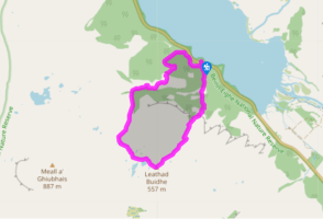
2hrs 45min
Difficulty:
Medium
Gradient:
Challenging
Distance:
3.5 miles (5.7kms)
Ascent:
1874ft (571m)
Walk directions
The route is well marked. Look out for cairns, and in the steeper sections, rough rock steps forming the path. From the end of the car park, turn left to pass under the road; immediately turn left again, following a sign for the Mountain Trail. The path goes under birches, with a stream on its right, then under pines. It then climbs slightly more steeply, across slabs of reddish sandstone, to the marker cairn named ‘Pines’. The path then climbs steeply up rough stone steps to a footbridge.
1 of 5
The path continues up more steps, now with the stream on its right. The ascent is very steep, but there are plenty of named cairns to stop at and read the trail booklet! The cairn 'Geology' is followed by Trumpet Rock. The cairn called ‘305m’ indicates the 1,000ft mark. Above, you can see how the quartzite, originally laid in flat layers on a seabed, now dips fairly steeply towards Loch Maree. The path passes along the base of a crag, then turns up left to a cairn called ‘Heather’. The path now ascends less steeply, over stony ground, to the walk's high point at the Conservation Cairn.
2 of 5
The cairn has a fine view up to Beinn Eighe. The rotten quartzite pinnacles, called the Black Carls, are seen more clearly from Kinlochewe. Their serrated outline gives the mountain its name, the Hill of the File. At the cairn the path turns right into a hummocky landscape of rocks and gravel – very much as the glaciers left it. Straight after leaving the Conservation Cairn you go down steep stone steps to pass a lochan, then reach another called Lunar Loch.
3 of 5
The path now heads downhill – the descent not quite so steep as the climb. The way descends to the left of the deep ravine of the Allt na h-Airighe. The path climbs a few steps to a knoll with a fine view along Loch Maree, with the Fossil Cairn just below this point. The path follows the gorge brink (well fenced), then bends down left. At the cairn called ‘Ice Age’, quartzite slabs show the scratches of the glacier that moved down the valley towards the left. The marks show most clearly on the fresh surface exposed by feet.
4 of 5
Back in the forest, turn left at a path junction where the Woodland Trail rejoins. Soon, a short side-path on the right leads to a view point cairn built in layers of quartzite, sandstone and gneiss. The path drops through the sheltering trees to run quite close to the road below. At a junction, turn down left under the road by the bridge of the outward walk.
Beinn Eighe is Britain’s oldest National Nature Reserve (1951) and the Mountain Trail is possibly Scotland’s toughest nature trail. The relentless ascent to the 1,800ft (548m) level takes you from luxuriant pine forest up to a mountain zone of bare stones and wind-chilled lochans. Pine times ... Scots pines once clothed all the valley sides of Wester Ross. The ones around Loch Maree were fed into the fires of an iron works directly opposite and the furnaces at Bonawe near Oban. More recently, ancient pines were felled to make ammunition boxes during World War II. Genetic analysis has shown that the pines here are related to those of France and Spain, whereas those in the Cairngorms and eastern Scotland spread after the Ice Age from northern Europe. Rocks of Ross In the path and under the small waterfalls, you’ll see that the bedrock changes from rounded red sandstone to angular pale-grey quartzite. From the cairn called ‘Geology’ you can see all three of the distinctive rocks of Wester Ross. Quartzite is underfoot. Across Loch Maree, the steep-sided stack of Slioch is Torridonian sandstone, standing on a base of greyish Lewisian gneiss. That ancient gneiss surface now uncovered from under the sandstone represents a landscape that first felt the air 800 million years ago. Wormholes in space and time The gneiss and sandstone date from long before multi-celled life on earth. The younger quartzite on top shows some of the oldest fossils and at the cairn called Trumpet Rock you can see some of them. These are the trumpet-shaped entrances of wormholes, made when the rock was still seabottom sludge. At the cairn called ‘460m’ you can see white marks the size of a thumb-print. These are the same wormholes as at Trumpet Rock, but further in, away from the entrances. This Pipe Rock provided a crucial clue to bewildered early geologists. Some of the Pipe Rock had the trumpets at the bottom: revealing that it had been turned completely upside down. Look ahead from the Conservation Cairn to the hill Meall a' Ghiuthais and see such an upside-down structure: the hill is made of the brownish Torridonian sandstone lying on top of the younger white quartzite. At the Fossil Cairn the rock is brownish-orange, called the Fucoid Beds. The fossils show as a ripply texture, like the surface of a kitchen sponge. 'Fucoid' is a sort of seaweed; this was a mistake by the early geologists, for the marks are another sort of wormhole. These were worms that wriggled along the seabed surface, and they were probably simple scavengers. The ones in the Pipe Rock, lurking in holes at right angles to the rock bedding, were fiercer predatory worms.
Apart from the Orkneys and the Shetlands, Highland is Scotland’s northernmost county. Probably its most famous feature is the mysterious and evocative Loch Ness, allegedly home to an ancient monster that has embedded itself in the world’s modern mythology, and the region’s tourist industry.