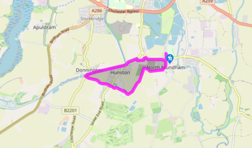
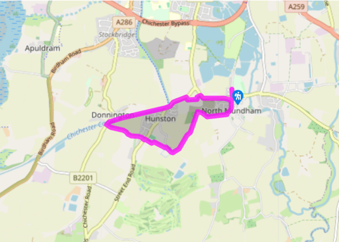
"A walk tracing the routes of the Chichester Ship Canal, the Portsmouth & Arundel Canal and the Selsey Tramway."
Walk directions
From the car park walk back up School Lane to the main road and cross via the pedestrian lights into Church Road. Follow the road curving right and pass the lychgate to North Mundham church. Just after, turn right on a path between hedges. Go through a kissing gate and keep ahead, following the hedge.
Go left at a footpath sign and alongside the field, on a track with a wood on your right, then on through the next, very large field. Go forward at a track junction shortly before buildings, then just before the first building turn right at the footpath sign onto a path that becomes a gravelled lane.
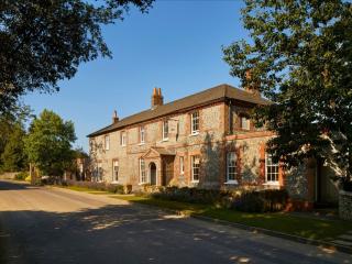
On the right is St Ledger’s Church and on the left beyond a reed-fringed pond is the Manor House, built about 1680. Just beyond the pond turn left at a footpath post and immediately right to continue alongside a post and wire fence. Through a hedge gap, go left along the edge of playing fields, left of a play area and over a footbridge.
Cross the B2145 Selsey Road, and continue ahead into Little Boultons. The track you cross just after the end of the houses is the trackbed of the Selsey Tramway. Carry on forward on a grassy track between fences, which later bends right and left towards farm buildings ahead. At the farm continue ahead to the right of a conifer hedge and along a gravel track.
Turn right along the road and just before a bridge bear right onto the tow path of the Chichester Ship Canal. Reaching housing you'll see the abutments of the former bridge by which the Selsey Tramway crossed the canal, while the footpath behind the houses continues along its trackbed.
Where the Chichester Canal bears left, take the path to the road. Cross over and turn left along it shortly with a hedge between the pavement and the road. At the end the path bears right, leaving the road and shortly bearing left, this path is also a cycle way. About 40 paces after it bears left again bear right onto a footpath.
At the road turn right along it back along the road into North Mundham, the Portsmouth and Arundel Canal remnants along the other side of the road amid the trees. Cross Church Road and at the pedestrian lights, the canal now behind you, cross into School Lane and the car park.
Terrain
- Field tracks and footpaths, canal tow path and lanes, 1 stile
Landscape
- Sussex Coastal plain, mainly arable and market gardening, and canalside
Dog friendliness
- On a lead on the lanes and in the villages
Parking
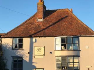
- North Mundham Playing Fields car park, School Lane
Toilets en route
- None on route
About the walk
Tale of two canals This route follows sections of two canals, one with water and looking good, the other something of an archaeological exercise. The better stretch is the Chichester Ship Canal. This flows from the Chichester Channel to Hunston, where it turns north towards the city, and was... capable of handling seagoing vessels of up to 100 tons and 18ft (5.5m) beam. It utilised and widened the Portsmouth & Arundel Canal route that is still traceable east of Hunston. Both canals opened in 1822, and the Chichester Ship Canal ended at the Southgate Canal Basin, south of the railway station in Chichester on the outskirts of the city. Its use declined from the mid-19th century, the last commercial cargo being 6 tons of ballast delivered to Chichester in 1906. The Portsmouth & Arundel Canal offered a safe inland route, out of range of potential naval bombardment. However, by the time it was built the Napoleonic Wars were over, and the coastal trade preferred the cheaper sea routes. By 1847 it was no longer navigable. Nowadays some stretches have a little water, while others have entirely been filled in. The reach between Hunston and Runcton is one of the more interesting sections, and you can glimpse water in the reedy, tree-screened channel – for example, by the pedestrian lights in North Mundham. The Siddlesham Snail The Selsey Tramway (unofficially and less flatteringly, ‘the Sidlesham Snail’) and West Sussex Railway was one of many light railway lines built by Colonel Stephens on a shoestring. It used converted buses with train wheels, as well as wheezy old tank engines. The line opened in 1897 and crossed the Chichester Canal by a lifting bridge, the abutments of which remain. It continued south from the canal along the footpath and beyond Point 4, to head across the flat coastal plain to Selsey. It was closed in 1935, having sustained irrevocable damage to its finances following floods that in 1910 washed away the southern section of the line at Sidlesham, and it was unable to compete with local motor buses.
"A walk tracing the routes of the Chichester Ship Canal, the Portsmouth & Arundel Canal and the Selsey Tramway."
Walk details
1hr 45min
Difficulty:
Easy
Gradient:
Flat
Distance:
3.5 miles (5.7kms)
Ascent:
0ft (0m)
Walk directions
From the car park walk back up School Lane to the main road and cross via the pedestrian lights into Church Road. Follow the road curving right and pass the lychgate to North Mundham church. Just after, turn right on a path between hedges. Go through a kissing gate and keep ahead, following the hedge.
1 of 7
Go left at a footpath sign and alongside the field, on a track with a wood on your right, then on through the next, very large field. Go forward at a track junction shortly before buildings, then just before the first building turn right at the footpath sign onto a path that becomes a gravelled lane.
2 of 7
On the right is St Ledger’s Church and on the left beyond a reed-fringed pond is the Manor House, built about 1680. Just beyond the pond turn left at a footpath post and immediately right to continue alongside a post and wire fence. Through a hedge gap, go left along the edge of playing fields, left of a play area and over a footbridge.
3 of 7
Cross the B2145 Selsey Road, and continue ahead into Little Boultons. The track you cross just after the end of the houses is the trackbed of the Selsey Tramway. Carry on forward on a grassy track between fences, which later bends right and left towards farm buildings ahead. At the farm continue ahead to the right of a conifer hedge and along a gravel track.
4 of 7
Turn right along the road and just before a bridge bear right onto the tow path of the Chichester Ship Canal. Reaching housing you'll see the abutments of the former bridge by which the Selsey Tramway crossed the canal, while the footpath behind the houses continues along its trackbed.
5 of 7
Where the Chichester Canal bears left, take the path to the road. Cross over and turn left along it shortly with a hedge between the pavement and the road. At the end the path bears right, leaving the road and shortly bearing left, this path is also a cycle way. About 40 paces after it bears left again bear right onto a footpath.
6 of 7
At the road turn right along it back along the road into North Mundham, the Portsmouth and Arundel Canal remnants along the other side of the road amid the trees. Cross Church Road and at the pedestrian lights, the canal now behind you, cross into School Lane and the car park.
Terrain
- Field tracks and footpaths, canal tow path and lanes, 1 stile
Landscape
- Sussex Coastal plain, mainly arable and market gardening, and canalside
Dog friendliness
- On a lead on the lanes and in the villages
Parking
- North Mundham Playing Fields car park, School Lane
Toilets en route
- None on route
About the walk
Tale of two canals This route follows sections of two canals, one with water and looking good, the other something of an archaeological exercise. The better stretch is the Chichester Ship Canal. This flows from the Chichester Channel to Hunston, where it turns north towards the city, and was... capable of handling seagoing vessels of up to 100 tons and 18ft (5.5m) beam. It utilised and widened the Portsmouth & Arundel Canal route that is still traceable east of Hunston. Both canals opened in 1822, and the Chichester Ship Canal ended at the Southgate Canal Basin, south of the railway station in Chichester on the outskirts of the city. Its use declined from the mid-19th century, the last commercial cargo being 6 tons of ballast delivered to Chichester in 1906. The Portsmouth & Arundel Canal offered a safe inland route, out of range of potential naval bombardment. However, by the time it was built the Napoleonic Wars were over, and the coastal trade preferred the cheaper sea routes. By 1847 it was no longer navigable. Nowadays some stretches have a little water, while others have entirely been filled in. The reach between Hunston and Runcton is one of the more interesting sections, and you can glimpse water in the reedy, tree-screened channel – for example, by the pedestrian lights in North Mundham. The Siddlesham Snail The Selsey Tramway (unofficially and less flatteringly, ‘the Sidlesham Snail’) and West Sussex Railway was one of many light railway lines built by Colonel Stephens on a shoestring. It used converted buses with train wheels, as well as wheezy old tank engines. The line opened in 1897 and crossed the Chichester Canal by a lifting bridge, the abutments of which remain. It continued south from the canal along the footpath and beyond Point 4, to head across the flat coastal plain to Selsey. It was closed in 1935, having sustained irrevocable damage to its finances following floods that in 1910 washed away the southern section of the line at Sidlesham, and it was unable to compete with local motor buses.