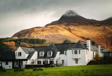
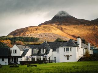
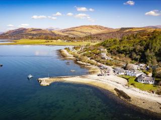
"A sea loch, a mountain loch and a pipeline path above deep wooded glens."
Walk directions
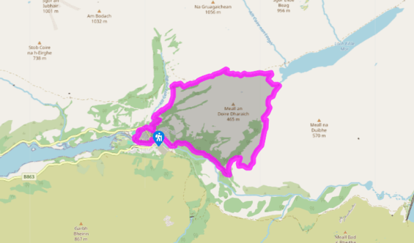
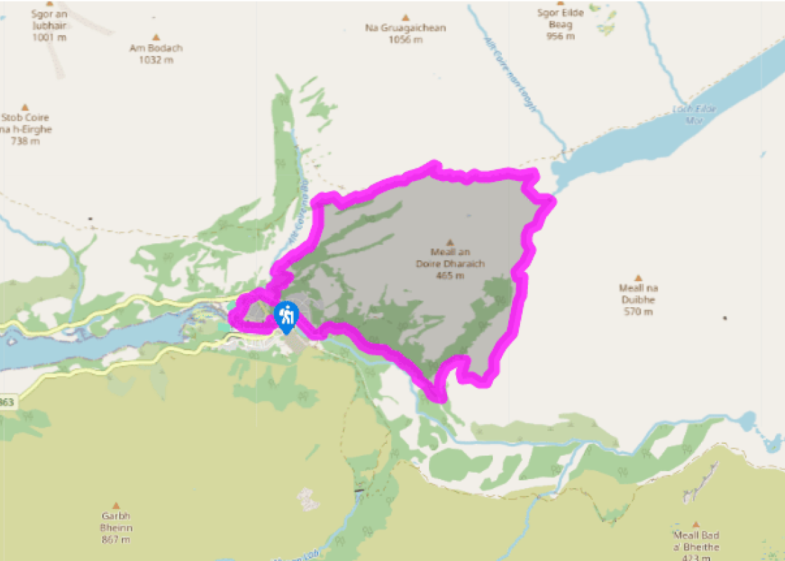
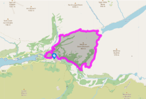
A smooth gravel path leads up out of the car park to a T-junction where you turn left towards Grey Mare's Tail Waterfall. After the path drops to cross a footbridge, down left takes you to the foot of the impressive waterfall, and up right is for the uphill path. This soon bends up sharp left and climbs steeply through birches to more open ground.
Fork right, with a yellow-and-green waymarker, to pass under two power lines. The path runs up to a gate in a deer fence, then bends left to cross over two streams. Immediately after the second one is another junction.
Turn right, following a yellow waymarker. The path climbs beside a stream, then bends right to cross it. It passes through a deer fence gate to reach a track. A continuation path rises briefly past a stone bench on an outcrop of red-orange rhyolite, then rejoins the track. Follow the track uphill to a wide pass. Just before it, a path on the right is a short-cut back to Kinlochleven.
At the pass is a view ahead along Loch Eilde Mor, which is Gaelic for Big Loch of the Hind. Descend for 0.25 miles (400m) to a path forking off on the right. After 330yds (300m), bend right. A smaller path ahead goes only to the loch foot, while the main path leads to the right of a knoll to a dam over the Allt na h-Eilde.
Turn right onto a rough and soggy track. This follows a concrete pipeline across the hill face, high above Kinlochleven, with fine views. After 1.25 miles (2km), the path drops below the pipeline and, in another 200yds (183m), a cairn marks a steep path descending on the right.
Turn down this path. To the left you can see the Crowberry Tower on distant Buachaille Etive Mor, outlined against the sky. The path zig-zags downhill until it enters the wood, but then rises slightly to join another path. Turn right on this. Look out for a waterfall view on your right; the path crosses the stream below it on a high footbridge. When you see buildings ahead, the main path forks down left to the edge of Kinlochleven.
The track ahead has a West Highland Way marker. Shortly it becomes a street; look for the tarred path on the left where the WHW turns back to the riverside. You pass the tailrace from the former smelter and continue to the road bridge. Continue under the bridge to a riverside path. It bends right, past black garages, to an earth path upstream alongside the Allt Coire na Ba. Where the path ends, you cross the B863 into Wades Road. This leads to the car park.
Aluminium is a very common metal: around 8 per cent of the earth’s crust is made up of it. But, it’s very reactive, which means that it’s extremely difficult to extract the aluminium atoms out of the ore called bauxite. There is no chemical method for this process. Instead, it’s done by dissolving... the ore in molten cryolite (a fluoride mineral) and applying vast quantities of electricity. As a result, aluminium processing doesn’t take place where you find the bauxite, but where you find the electricity, with lots of water coming down steep hillsides, and a deep-water harbour at the bottom, such as Kinlochleven. The village of Kinlochleven was built around the smelter. Two lochs above have been dammed for hydro-electricity, and six huge pipes bring the water down from a control station above the Devil’s Staircase footpath. Pipeline or path A pipeline on the OS Landranger map is a dotted line, rather like a path. And it may be that the path of this walk happened by mistake, as walkers mistook the pipeline for a path, walked along it and so created the path that they thought was there in the first place. The pipeline path leads from the outflow of Loch Eilde Mor, around the head of Loch Leven along the 1,100ft (330m) contour, giving superb views towards the Pap of Glencoe and the loch’s foot. Eventually it carries Loch Eilde’s water to the Blackwater Reservoir. Why has the water from Loch Eilde been taken all the way round this hillside to the Blackwater Reservoir, instead of straight down to the turbines where it’s actually needed? You need to glance across the valley at the six descending pipes for the answer. At the foot of those huge reinforced pipes the water is under 30 tons per sq ft (300 tonnes/sq m) of pressure. A second such set from Loch Eilde would cost far more than the much longer, unpressurised pipe to the other reservoir. The Kinlochmore smelter started as one of the largest in the world, but by the end of the 1900s it was the world’s smallest. It closed in 2000, although its turbines continue to generate electricity, which is now diverted to the smelter at Fort William or into the National Grid. The smelter had been the reason for Kinlochleven, and its main employer. Projects to keep Kinlochleven alive include the newly constructed path system, the visitor centre and the Atlas Brewery (now closed) on the site where carbon electrical connectors were once made.
Apart from the Orkneys and the Shetlands, Highland is Scotland’s northernmost county. Probably its most famous feature is the mysterious and evocative Loch Ness, allegedly home to an ancient monster that has embedded itself in the world’s modern mythology, and the region’s tourist industry.
"A sea loch, a mountain loch and a pipeline path above deep wooded glens."
Walk details
3hrs 45min
Difficulty:
Medium
Gradient:
Challenging
Distance:
7.5 miles (12.1kms)
Ascent:
1400ft (427m)
Walk directions
A smooth gravel path leads up out of the car park to a T-junction where you turn left towards Grey Mare's Tail Waterfall. After the path drops to cross a footbridge, down left takes you to the foot of the impressive waterfall, and up right is for the uphill path. This soon bends up sharp left and climbs steeply through birches to more open ground.
1 of 7
Fork right, with a yellow-and-green waymarker, to pass under two power lines. The path runs up to a gate in a deer fence, then bends left to cross over two streams. Immediately after the second one is another junction.
2 of 7
Turn right, following a yellow waymarker. The path climbs beside a stream, then bends right to cross it. It passes through a deer fence gate to reach a track. A continuation path rises briefly past a stone bench on an outcrop of red-orange rhyolite, then rejoins the track. Follow the track uphill to a wide pass. Just before it, a path on the right is a short-cut back to Kinlochleven.
3 of 7
At the pass is a view ahead along Loch Eilde Mor, which is Gaelic for Big Loch of the Hind. Descend for 0.25 miles (400m) to a path forking off on the right. After 330yds (300m), bend right. A smaller path ahead goes only to the loch foot, while the main path leads to the right of a knoll to a dam over the Allt na h-Eilde.
4 of 7
Turn right onto a rough and soggy track. This follows a concrete pipeline across the hill face, high above Kinlochleven, with fine views. After 1.25 miles (2km), the path drops below the pipeline and, in another 200yds (183m), a cairn marks a steep path descending on the right.
5 of 7
Turn down this path. To the left you can see the Crowberry Tower on distant Buachaille Etive Mor, outlined against the sky. The path zig-zags downhill until it enters the wood, but then rises slightly to join another path. Turn right on this. Look out for a waterfall view on your right; the path crosses the stream below it on a high footbridge. When you see buildings ahead, the main path forks down left to the edge of Kinlochleven.
6 of 7
The track ahead has a West Highland Way marker. Shortly it becomes a street; look for the tarred path on the left where the WHW turns back to the riverside. You pass the tailrace from the former smelter and continue to the road bridge. Continue under the bridge to a riverside path. It bends right, past black garages, to an earth path upstream alongside the Allt Coire na Ba. Where the path ends, you cross the B863 into Wades Road. This leads to the car park.
Aluminium is a very common metal: around 8 per cent of the earth’s crust is made up of it. But, it’s very reactive, which means that it’s extremely difficult to extract the aluminium atoms out of the ore called bauxite. There is no chemical method for this process. Instead, it’s done by dissolving... the ore in molten cryolite (a fluoride mineral) and applying vast quantities of electricity. As a result, aluminium processing doesn’t take place where you find the bauxite, but where you find the electricity, with lots of water coming down steep hillsides, and a deep-water harbour at the bottom, such as Kinlochleven. The village of Kinlochleven was built around the smelter. Two lochs above have been dammed for hydro-electricity, and six huge pipes bring the water down from a control station above the Devil’s Staircase footpath. Pipeline or path A pipeline on the OS Landranger map is a dotted line, rather like a path. And it may be that the path of this walk happened by mistake, as walkers mistook the pipeline for a path, walked along it and so created the path that they thought was there in the first place. The pipeline path leads from the outflow of Loch Eilde Mor, around the head of Loch Leven along the 1,100ft (330m) contour, giving superb views towards the Pap of Glencoe and the loch’s foot. Eventually it carries Loch Eilde’s water to the Blackwater Reservoir. Why has the water from Loch Eilde been taken all the way round this hillside to the Blackwater Reservoir, instead of straight down to the turbines where it’s actually needed? You need to glance across the valley at the six descending pipes for the answer. At the foot of those huge reinforced pipes the water is under 30 tons per sq ft (300 tonnes/sq m) of pressure. A second such set from Loch Eilde would cost far more than the much longer, unpressurised pipe to the other reservoir. The Kinlochmore smelter started as one of the largest in the world, but by the end of the 1900s it was the world’s smallest. It closed in 2000, although its turbines continue to generate electricity, which is now diverted to the smelter at Fort William or into the National Grid. The smelter had been the reason for Kinlochleven, and its main employer. Projects to keep Kinlochleven alive include the newly constructed path system, the visitor centre and the Atlas Brewery (now closed) on the site where carbon electrical connectors were once made.
Apart from the Orkneys and the Shetlands, Highland is Scotland’s northernmost county. Probably its most famous feature is the mysterious and evocative Loch Ness, allegedly home to an ancient monster that has embedded itself in the world’s modern mythology, and the region’s tourist industry.