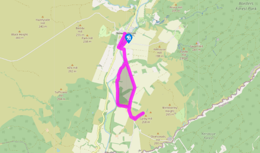
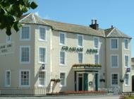
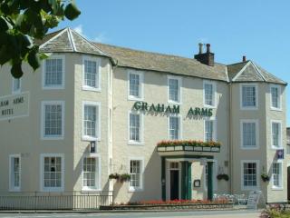
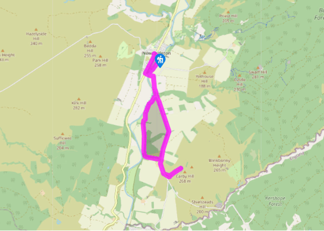
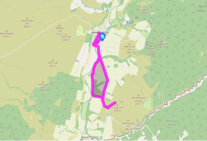
From Douglas Square in the centre of Newcastleton, with your back to the Grapes Hotel, walk along Whitchester Street (or any of the other streets opposite) and go down to the river, the Liddel Water. Turn right, then walk along the riverbank and join the footpath downstream to reach Holm Bridge. Here, turn left at the top of the steps and then cross over the bridge.
After about 100yds (91m), turn right and follow the Brampton Road until you reach the Tweeden Burn Bridge. Cross the bridge and walk uphill, then turn right and join the metalled track signed for Riverview Holiday Park. Continue on this road until you near the farm buildings.
At the farm entrance, fork left onto the bed of the old railway line, which has joined you from the right. This line once linked Carlisle to Edinburgh but was closed following the Beeching cuts of 1963. Follow the line as it leads past the remains of Mangerton Tower, in a field to your right, and continue ahead until you reach Clerkleap Cottage.
Walk 50yds (45m) beyond the cottage and turn left through a metal gate. A rough path leads up left, then turns right to join a rough track. This leads through woodland and on, uphill, to join the road by Sorbietrees farm. Turn right now and walk along the road, past the farm, to a small stand of conifers on the left. Turn left through the gate.
Bear right now and head up the left-hand side of the trees. Walk past the top of the wood, following a drystone wall up below a former quarry to the field's top corner. Climb over the field gate ahead. Now open grassy slopes lead up left, to the cairn and fallen walls on the summit of Carby Hill. The views are truly great from here. Known locally as Caerba Hill, this was the site of a prehistoric settlement.
Retrace your steps to reach the road again, then turn right and walk back past Sorbietrees farm.
At the farm, continue on the main road as it bears right and follow it back over the Tweeden Burn Bridge and up to the Holm Bridge. Cross the bridge and walk straight on for 100yds (91m), then turn right onto the B6357 and walk back to the village square via the little heritage centre.
It might seem quiet today, but the area around Newcastleton was once what tabloid newspapers would describe as 'war-torn'. Ownership of these borderlands was hotly disputed between England and Scotland for hundreds of years and there were frequent battles and skirmishes. You'll pass a reminder of... those turbulent days on this walk. Raids and revenge Because places like Newcastleton were so remote from the centres of power in both London and Edinburgh, they were difficult to defend and had a reputation for lawlessness. Feuds often developed between powerful local families, and violent raids and cases of cattle rustling (reiving) were common – cattle were a valuable asset. These were ruthless people who could probably have shown the Vikings a thing or two. A raid would commonly be followed by an illegal revenge attack or sometimes a legal 'Hot Trod'. This was a pursuit mounted immediately after a raid and had strict rules – including one stating that a lighted turf had to be carried if the trod crossed the border. When reivers were caught they were often taken hostage (the ransom money was very handy), taken prisoner, or even killed. Not surprisingly the countryside became studded with sturdy castles and fortified 'pele' towers, so that people could better defend themselves. The most powerful family in this area were the Armstrongs, the principal reiving clan in the Borders. They were extremely influential and held large tracts of land. Their main seat was Mangerton Tower, the rather pitiful remains of which you can see on this walk. The Armstrongs were said to be able to muster 3,000 mounted men whenever they wished to launch a raid into England. They were ruthless and violent, running a successful protection racket as one of their money-making ventures. Imagine the mafia with cows and you'll get the picture. An end to reiving It wasn't until the Union of the Crowns took place in 1603, following the death of Queen Elizabeth I, that the Border wars ceased and the power of the reiving clans was finally dispersed. Keen to gain control and make his mark as an effective ruler of the new United Kingdom, James VI of Scotland (James I of England) banned weapons and established mounted forces to police the area. Reiving families – often identified with the help of local informers – were scattered, and members transported or even executed. After Archibald Armstrong of Mangerton was executed in 1610, the Armstrongs lost their lands to the Scotts, another powerful local family. However, the family didn't disappear and members of this once fearsome tribe have continued to make their mark on the world. Most famous of all must be Neil Armstrong, who carried a fragment of Armstrong tartan when he stepped onto the surface of the moon in 1969.
Southern Scotland is often referred to as the Lowlands, to distinguish it from the mountainous grandeur of the North-West Highlands. But don’t be fooled by the description.
From Douglas Square in the centre of Newcastleton, with your back to the Grapes Hotel, walk along Whitchester Street (or any of the other streets opposite) and go down to the river, the Liddel Water. Turn right, then walk along the riverbank and join the footpath downstream to reach Holm Bridge. Here, turn left at the top of the steps and then cross over the bridge.
1 of 7
After about 100yds (91m), turn right and follow the Brampton Road until you reach the Tweeden Burn Bridge. Cross the bridge and walk uphill, then turn right and join the metalled track signed for Riverview Holiday Park. Continue on this road until you near the farm buildings.
2 of 7
At the farm entrance, fork left onto the bed of the old railway line, which has joined you from the right. This line once linked Carlisle to Edinburgh but was closed following the Beeching cuts of 1963. Follow the line as it leads past the remains of Mangerton Tower, in a field to your right, and continue ahead until you reach Clerkleap Cottage.
3 of 7
Walk 50yds (45m) beyond the cottage and turn left through a metal gate. A rough path leads up left, then turns right to join a rough track. This leads through woodland and on, uphill, to join the road by Sorbietrees farm. Turn right now and walk along the road, past the farm, to a small stand of conifers on the left. Turn left through the gate.
4 of 7
Bear right now and head up the left-hand side of the trees. Walk past the top of the wood, following a drystone wall up below a former quarry to the field's top corner. Climb over the field gate ahead. Now open grassy slopes lead up left, to the cairn and fallen walls on the summit of Carby Hill. The views are truly great from here. Known locally as Caerba Hill, this was the site of a prehistoric settlement.
5 of 7
Retrace your steps to reach the road again, then turn right and walk back past Sorbietrees farm.
6 of 7
At the farm, continue on the main road as it bears right and follow it back over the Tweeden Burn Bridge and up to the Holm Bridge. Cross the bridge and walk straight on for 100yds (91m), then turn right onto the B6357 and walk back to the village square via the little heritage centre.
It might seem quiet today, but the area around Newcastleton was once what tabloid newspapers would describe as 'war-torn'. Ownership of these borderlands was hotly disputed between England and Scotland for hundreds of years and there were frequent battles and skirmishes. You'll pass a reminder of... those turbulent days on this walk. Raids and revenge Because places like Newcastleton were so remote from the centres of power in both London and Edinburgh, they were difficult to defend and had a reputation for lawlessness. Feuds often developed between powerful local families, and violent raids and cases of cattle rustling (reiving) were common – cattle were a valuable asset. These were ruthless people who could probably have shown the Vikings a thing or two. A raid would commonly be followed by an illegal revenge attack or sometimes a legal 'Hot Trod'. This was a pursuit mounted immediately after a raid and had strict rules – including one stating that a lighted turf had to be carried if the trod crossed the border. When reivers were caught they were often taken hostage (the ransom money was very handy), taken prisoner, or even killed. Not surprisingly the countryside became studded with sturdy castles and fortified 'pele' towers, so that people could better defend themselves. The most powerful family in this area were the Armstrongs, the principal reiving clan in the Borders. They were extremely influential and held large tracts of land. Their main seat was Mangerton Tower, the rather pitiful remains of which you can see on this walk. The Armstrongs were said to be able to muster 3,000 mounted men whenever they wished to launch a raid into England. They were ruthless and violent, running a successful protection racket as one of their money-making ventures. Imagine the mafia with cows and you'll get the picture. An end to reiving It wasn't until the Union of the Crowns took place in 1603, following the death of Queen Elizabeth I, that the Border wars ceased and the power of the reiving clans was finally dispersed. Keen to gain control and make his mark as an effective ruler of the new United Kingdom, James VI of Scotland (James I of England) banned weapons and established mounted forces to police the area. Reiving families – often identified with the help of local informers – were scattered, and members transported or even executed. After Archibald Armstrong of Mangerton was executed in 1610, the Armstrongs lost their lands to the Scotts, another powerful local family. However, the family didn't disappear and members of this once fearsome tribe have continued to make their mark on the world. Most famous of all must be Neil Armstrong, who carried a fragment of Armstrong tartan when he stepped onto the surface of the moon in 1969.
Southern Scotland is often referred to as the Lowlands, to distinguish it from the mountainous grandeur of the North-West Highlands. But don’t be fooled by the description.