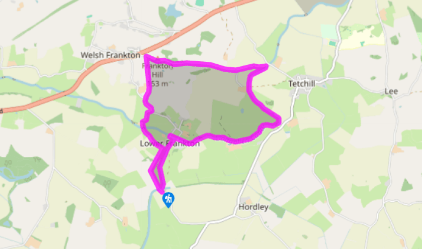
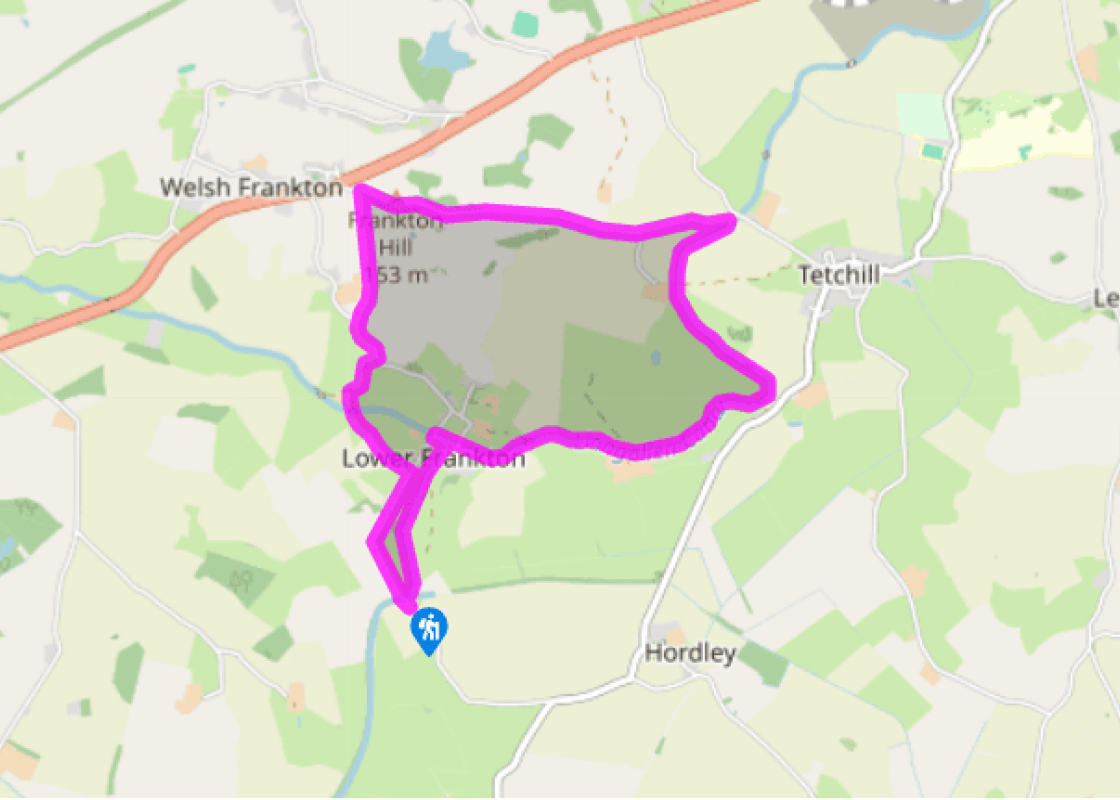
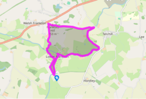
From the car park, walk over the steep Lockgate Bridge and continue along the lane for 0.5 miles (800m) to a stile and footpath sign in the hedge on the left opposite farm buildings. Go straight across a field to the next stile and continue through more small fields over a series of stiles. You’re effectively following the same hedge-line, though you do switch sides a couple of times.
Cross a plank bridge between two stiles then bear half-left to a canal bridge. Don’t cross the stile onto the towpath but go over the bridge (you may need to go round a section of fence to access it). Go through a gate, or use the stile on the right if not blocked by barbed wire, and along a short green track to a yard (Frankton Farm). Go right a few paces then walk between the buildings to a lane.
Go up the very quiet lane to a T-junction and turn left. After a couple of bends you’ll reach steps and a stile on the right, with a footpath sign on the other side of the road. Go up a field to cross a track just left of a large oak.
Go through a metal gate and continue up the next field. As you go over a slight rise you’ll see two gates ahead. Cross two stiles in the hedge between these gates and go straight up another field to a gate onto a lane.
Turn right along the quiet lane for almost a mile (1.5km). It runs along a slight ridge and there are intermittent views to the south. It descends gradually. After Canal Cottage, and just before Coachman’s Bridge, you can join the towpath. Turn right, almost doubling back on yourself.
Follow the towpath for almost 2 miles (3.2km) to Frankton Junction. Pass under Bridge 69 and continue to the next, which is not 70 but 1W. Cross this bridge then turn left to join the towpath (and the Shropshire Way), following the canal down past Frankton Locks to Lockgate Bridge. Cross the bridge to return to the car park.
The waterway that we now call the Montgomery Canal runs for 35 miles (56km) from the Llangollen (formerly Ellesmere) Canal at Frankton Junction to Newtown, Powys. Originally, it was three canals – the Ellesmere, and the eastern and western branches of the Montgomery – built by three different... companies over 25 years. The Ellesmere (Frankton to Llanymynech) section opened first, in 1796. The Montgomery Canal was not completed through to Newtown until 1819. The Monty became part of the Shropshire Union Railway and Canal Company (the Shroppie), in turn taken over by the London and North Western Railway Company. In 1923, it came into the ownership of the London, Midland and Scottish Railway Company (LMS). In 1936, the canal burst its banks by the River Perry below Frankton Locks. The LMS made no effort to repair it; the canal was simply left to its fate. Legal abandonment came in 1944 with the LMS Act of Parliament, which closed many miles of waterway. Under the 1948 Transport Act, the Monty passed into the ownership of British Waterways. Restoration work began in 1968; for more information turn to Walk 31. Frankton Junction became the hub of the Ellesmere system. There are actually two junctions, forming an H-shape, both of which you’ll see on this walk. From these, the waterways radiated out to Ellesmere, Pontcysyllte and Llanymynech. The limestone quarries at Llanymynech provided one of the canal’s most valuable cargoes. The Weston arm of the canal was intended to continue to Shrewsbury, but got no further than Weston Lullingfields, rather less than half the distance. It’s derelict today, but its course can mostly be traced across the ground and on OS maps. Many renowned engineers were involved with the Monty, including fatherand-son teams William and Josias Jessop and John and Thomas Dadford, as well as Thomas Telford. In engineering terms it’s an unusual canal; it first descends by 11 locks from Frankton to the Severn, then climbs again, with 14 locks taking it up the Severn Valley to Newtown. As you’ll see, there are four locks in quick succession at Frankton itself, and the first two of them are combined, forming a lock staircase. Staircase locks are more complex to operate than simple locks and can cause novice boaters a few headaches. With single locks, the system is most efficient if ascending and descending boats alternate, but staircase locks are more efficient if successive boats travel in the same direction. Staircase locks are usually supervised and boats are often required to book passage in advance, as is the case at Frankton, where a maximum of 12 boats per day are normally allowed through in each direction.
Perhaps nowhere else in England will you find a county so deeply rural and with so much variety as Shropshire. Choose a clear day, climb to the top of The Wrekin, and look down on that ‘land of lost content’ so wistfully evoked by A E Housman.
From the car park, walk over the steep Lockgate Bridge and continue along the lane for 0.5 miles (800m) to a stile and footpath sign in the hedge on the left opposite farm buildings. Go straight across a field to the next stile and continue through more small fields over a series of stiles. You’re effectively following the same hedge-line, though you do switch sides a couple of times.
1 of 6
Cross a plank bridge between two stiles then bear half-left to a canal bridge. Don’t cross the stile onto the towpath but go over the bridge (you may need to go round a section of fence to access it). Go through a gate, or use the stile on the right if not blocked by barbed wire, and along a short green track to a yard (Frankton Farm). Go right a few paces then walk between the buildings to a lane.
2 of 6
Go up the very quiet lane to a T-junction and turn left. After a couple of bends you’ll reach steps and a stile on the right, with a footpath sign on the other side of the road. Go up a field to cross a track just left of a large oak.
3 of 6
Go through a metal gate and continue up the next field. As you go over a slight rise you’ll see two gates ahead. Cross two stiles in the hedge between these gates and go straight up another field to a gate onto a lane.
4 of 6
Turn right along the quiet lane for almost a mile (1.5km). It runs along a slight ridge and there are intermittent views to the south. It descends gradually. After Canal Cottage, and just before Coachman’s Bridge, you can join the towpath. Turn right, almost doubling back on yourself.
5 of 6
Follow the towpath for almost 2 miles (3.2km) to Frankton Junction. Pass under Bridge 69 and continue to the next, which is not 70 but 1W. Cross this bridge then turn left to join the towpath (and the Shropshire Way), following the canal down past Frankton Locks to Lockgate Bridge. Cross the bridge to return to the car park.
The waterway that we now call the Montgomery Canal runs for 35 miles (56km) from the Llangollen (formerly Ellesmere) Canal at Frankton Junction to Newtown, Powys. Originally, it was three canals – the Ellesmere, and the eastern and western branches of the Montgomery – built by three different... companies over 25 years. The Ellesmere (Frankton to Llanymynech) section opened first, in 1796. The Montgomery Canal was not completed through to Newtown until 1819. The Monty became part of the Shropshire Union Railway and Canal Company (the Shroppie), in turn taken over by the London and North Western Railway Company. In 1923, it came into the ownership of the London, Midland and Scottish Railway Company (LMS). In 1936, the canal burst its banks by the River Perry below Frankton Locks. The LMS made no effort to repair it; the canal was simply left to its fate. Legal abandonment came in 1944 with the LMS Act of Parliament, which closed many miles of waterway. Under the 1948 Transport Act, the Monty passed into the ownership of British Waterways. Restoration work began in 1968; for more information turn to Walk 31. Frankton Junction became the hub of the Ellesmere system. There are actually two junctions, forming an H-shape, both of which you’ll see on this walk. From these, the waterways radiated out to Ellesmere, Pontcysyllte and Llanymynech. The limestone quarries at Llanymynech provided one of the canal’s most valuable cargoes. The Weston arm of the canal was intended to continue to Shrewsbury, but got no further than Weston Lullingfields, rather less than half the distance. It’s derelict today, but its course can mostly be traced across the ground and on OS maps. Many renowned engineers were involved with the Monty, including fatherand-son teams William and Josias Jessop and John and Thomas Dadford, as well as Thomas Telford. In engineering terms it’s an unusual canal; it first descends by 11 locks from Frankton to the Severn, then climbs again, with 14 locks taking it up the Severn Valley to Newtown. As you’ll see, there are four locks in quick succession at Frankton itself, and the first two of them are combined, forming a lock staircase. Staircase locks are more complex to operate than simple locks and can cause novice boaters a few headaches. With single locks, the system is most efficient if ascending and descending boats alternate, but staircase locks are more efficient if successive boats travel in the same direction. Staircase locks are usually supervised and boats are often required to book passage in advance, as is the case at Frankton, where a maximum of 12 boats per day are normally allowed through in each direction.
Perhaps nowhere else in England will you find a county so deeply rural and with so much variety as Shropshire. Choose a clear day, climb to the top of The Wrekin, and look down on that ‘land of lost content’ so wistfully evoked by A E Housman.