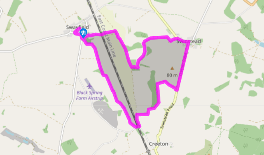
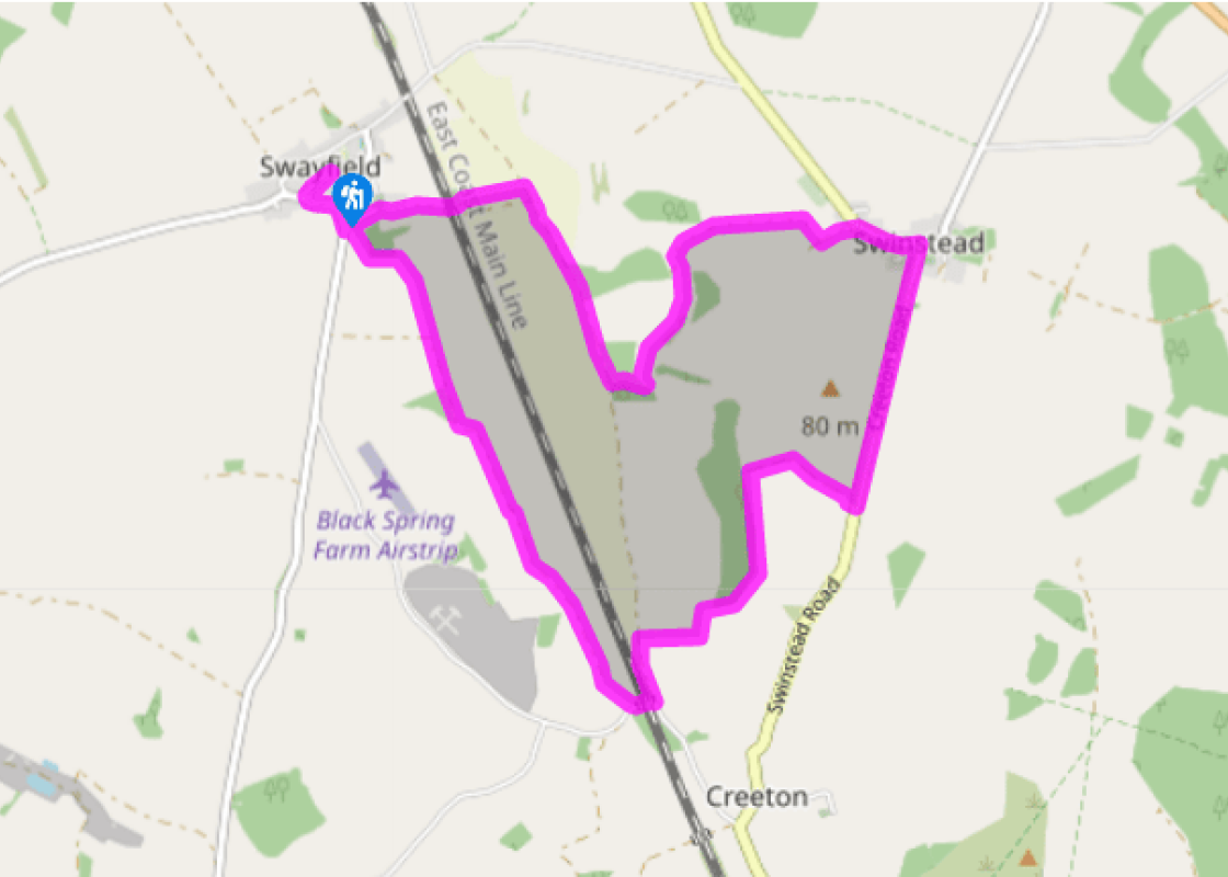
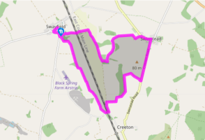
With your back to The Royal Oak in Swayfield turn right and walk along to a junction. Go left on to Castle Bytham Road and then left into Water Lane on the edge of the village. After 50yds (46m) turn right over a stile and cross the field to the far corner. Go half left in the next field and beyond a footbridge go up the middle of a further field to join an open farm track.
Walk straight ahead on this direct and undulating route, with the railway over to your left, until in about a mile (1.6km) you pass a farmhouse and drop down to a road. Turn left and go under the railway bridge, then immediately left on a wide dirt track – a section of The Drift. After 300yds (274m) turn right on a signposted footpath along the edge of a field. At the bottom go left along the side of another, then right at the marker post to cross the river by a footbridge.
Go up the left side of a sloping field by woodland. Follow it round to the left and when you reach an isolated, mature tree turn right on the wide track across fields to Creeton Farm. As you reach the main buildings go through the field entrance on the left to skirt the farm and out on to the road via a footbridge in the hedge.
Turn left and walk the lane all the way into Swinstead. Go past the church and at the old market cross in the centre bear left and follow the road out of the village. Just before you reach the last houses go left on a public footpath along a vehicle track. Where the hedge on the right ends turn right by a gate for a field-edge path. Continue beyond a stile and about 100yds (91m) before a small wood go over a stile in the hedge on the left. Head diagonally right down across a field.
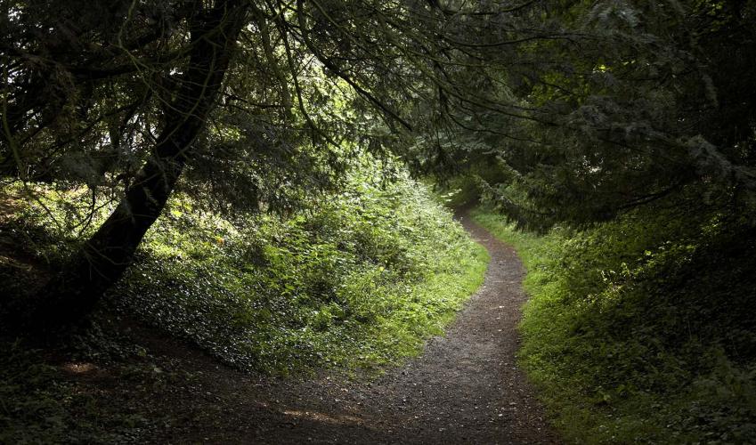
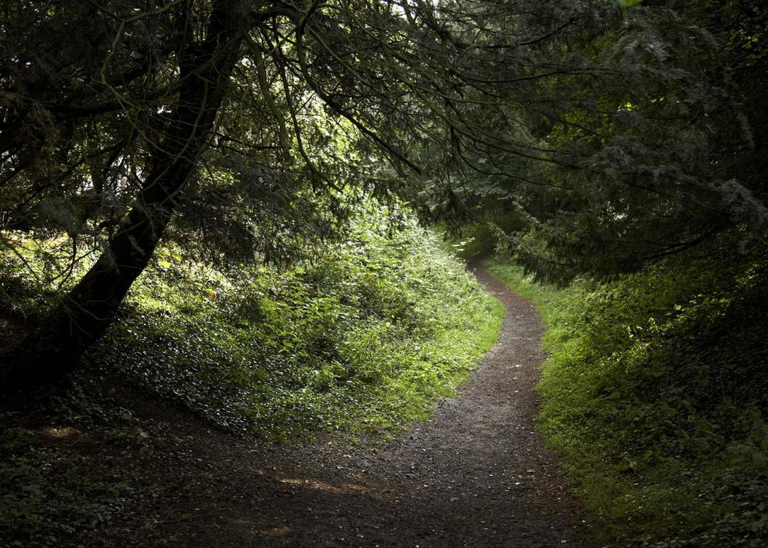
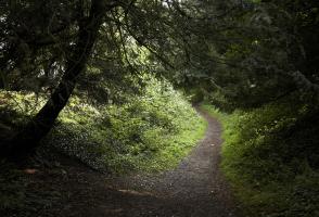
When you reach West Glen River at the bottom turn left along its meandering banks. Ignore the first footbridge and cross a second further along. Go left to reach a stile and then a short, sharp ascent through trees. At the top turn right and follow the winding track out on to The Drift.
Turn right and walk this wide, hedged route for 0.25 miles (400m), then go left on a footpath along a field edge and under the railway. Head half right across a field to join a farm track and driveway, past Church Farm, and then along the lane ahead to reach the junction at the end of Water Lane. Turn right to return to the centre of Swayfield.
This walk follows short sections of an ancient route called The Drift, today a peaceful and unsurfaced hedged trail but once used by herdsmen to drive their livestock between pastures and to market. Historically the term ‘drift’ has been used to denote a herd or drove, often of pigs or cattle, and... other routes known as ‘The Drift’ can be found at nearby Harlaxton and Wyville. It must have been quite a spectacle as herds of livestock were routinely moved to and fro these rural arteries, not just in the rural East Midlands but all over the country. The village of Swinstead, which you visit on this walk, derives its name from the Old English ‘Swinsteda’ meaning the homestead where swine (pigs) are reared. A faster way to travel Parallel to The Drift and in an interesting juxtaposition, the historic old route is rather overshadowed by a high-speed railway line, but one that has established its place in railway folklore. This section of the East Coast mainline is known as Stoke Bank and runs gently and directly downhill from Stoke tunnel, about 5 miles (8km) to the north, near Grantham. On this line in 1934 the steam engine Flying Scotsman was the first to achieve a speed of 100mph; then four years laterMallard recorded a world record speed for a steam locomotive of 126mph, just a few miles south of here between Little Bytham and Essendine. Mallard was designed by Sir Nigel Gresley for the London & North Eastern Railway and with its aerodynamic design, supposedly inspired by Bugatti racing cars, it represented the high point of British locomotive building.Mallard’s record still stands to this day. Secrets of the West Glen Compared to the wide open thoroughfare of The Drift, the West Glen River snakes its way quietly and unobtrusively through the Lincolnshire countryside, almost hidden from view, and here in the Swinstead Valley it usually disappears altogether for months at a time as the water is lost through the thin soil and porous limestone. However, the steep-sided valley, characterised by short springy turf, is an important example of what’s known as lowland calcareous grassland. Because it’s carefully and sensitively managed – grazed by livestock and not sprayed by pesticides, for example – it is rich in wild flowers and supports an incredibly diverse plant community. Different grasses, sedges and clovers all thrive on the nutrient-poor soils, and the array of flowering plants in turn supports a healthy insect population, including butterflies like skippers and blues. Once the countryside of the East Midlands was rich in this sort of ‘unimproved’ grassland, but thanks to intensive agricultural practices and the inevitable modern development of roads and houses it is an increasingly rare habitat.
Much of the fenland around the Wash has been drained of its marshes and reclaimed as highly productive farmland. Further north, the coastline, with its sandy beaches, has been developed to accommodate the holiday industry, with caravans, campsites and the usual seaside paraphernalia.
With your back to The Royal Oak in Swayfield turn right and walk along to a junction. Go left on to Castle Bytham Road and then left into Water Lane on the edge of the village. After 50yds (46m) turn right over a stile and cross the field to the far corner. Go half left in the next field and beyond a footbridge go up the middle of a further field to join an open farm track.
1 of 6
Walk straight ahead on this direct and undulating route, with the railway over to your left, until in about a mile (1.6km) you pass a farmhouse and drop down to a road. Turn left and go under the railway bridge, then immediately left on a wide dirt track – a section of The Drift. After 300yds (274m) turn right on a signposted footpath along the edge of a field. At the bottom go left along the side of another, then right at the marker post to cross the river by a footbridge.
2 of 6
Go up the left side of a sloping field by woodland. Follow it round to the left and when you reach an isolated, mature tree turn right on the wide track across fields to Creeton Farm. As you reach the main buildings go through the field entrance on the left to skirt the farm and out on to the road via a footbridge in the hedge.
3 of 6
Turn left and walk the lane all the way into Swinstead. Go past the church and at the old market cross in the centre bear left and follow the road out of the village. Just before you reach the last houses go left on a public footpath along a vehicle track. Where the hedge on the right ends turn right by a gate for a field-edge path. Continue beyond a stile and about 100yds (91m) before a small wood go over a stile in the hedge on the left. Head diagonally right down across a field.
4 of 6
When you reach West Glen River at the bottom turn left along its meandering banks. Ignore the first footbridge and cross a second further along. Go left to reach a stile and then a short, sharp ascent through trees. At the top turn right and follow the winding track out on to The Drift.
5 of 6
Turn right and walk this wide, hedged route for 0.25 miles (400m), then go left on a footpath along a field edge and under the railway. Head half right across a field to join a farm track and driveway, past Church Farm, and then along the lane ahead to reach the junction at the end of Water Lane. Turn right to return to the centre of Swayfield.
This walk follows short sections of an ancient route called The Drift, today a peaceful and unsurfaced hedged trail but once used by herdsmen to drive their livestock between pastures and to market. Historically the term ‘drift’ has been used to denote a herd or drove, often of pigs or cattle, and... other routes known as ‘The Drift’ can be found at nearby Harlaxton and Wyville. It must have been quite a spectacle as herds of livestock were routinely moved to and fro these rural arteries, not just in the rural East Midlands but all over the country. The village of Swinstead, which you visit on this walk, derives its name from the Old English ‘Swinsteda’ meaning the homestead where swine (pigs) are reared. A faster way to travel Parallel to The Drift and in an interesting juxtaposition, the historic old route is rather overshadowed by a high-speed railway line, but one that has established its place in railway folklore. This section of the East Coast mainline is known as Stoke Bank and runs gently and directly downhill from Stoke tunnel, about 5 miles (8km) to the north, near Grantham. On this line in 1934 the steam engine Flying Scotsman was the first to achieve a speed of 100mph; then four years laterMallard recorded a world record speed for a steam locomotive of 126mph, just a few miles south of here between Little Bytham and Essendine. Mallard was designed by Sir Nigel Gresley for the London & North Eastern Railway and with its aerodynamic design, supposedly inspired by Bugatti racing cars, it represented the high point of British locomotive building.Mallard’s record still stands to this day. Secrets of the West Glen Compared to the wide open thoroughfare of The Drift, the West Glen River snakes its way quietly and unobtrusively through the Lincolnshire countryside, almost hidden from view, and here in the Swinstead Valley it usually disappears altogether for months at a time as the water is lost through the thin soil and porous limestone. However, the steep-sided valley, characterised by short springy turf, is an important example of what’s known as lowland calcareous grassland. Because it’s carefully and sensitively managed – grazed by livestock and not sprayed by pesticides, for example – it is rich in wild flowers and supports an incredibly diverse plant community. Different grasses, sedges and clovers all thrive on the nutrient-poor soils, and the array of flowering plants in turn supports a healthy insect population, including butterflies like skippers and blues. Once the countryside of the East Midlands was rich in this sort of ‘unimproved’ grassland, but thanks to intensive agricultural practices and the inevitable modern development of roads and houses it is an increasingly rare habitat.
Much of the fenland around the Wash has been drained of its marshes and reclaimed as highly productive farmland. Further north, the coastline, with its sandy beaches, has been developed to accommodate the holiday industry, with caravans, campsites and the usual seaside paraphernalia.