Lynton to Simonsbath

Follow the route – Lynton to Simonsbath

Lynton to Lynmouth
> From Lynton take the B3234, dropping very steeply down into Lynmouth.
Visiting Lynmouth
Lynmouth is at the confluence of the East and West Lyn rivers. The 1890 cliff railway still provides a link with Lynton by means of two railcars; the top car uses water ballast to haul the other one up from the bottom. The River Lyn is very strongly embanked now and on leaving the town you will see the gorge down which the flood water came with such devastation in 1952. The poet Shelley lived in Lynmouth for a time.
Places to stay in Lynmouth

Lynmouth to Malmsmead
> Leave on the A39 towards Barnstaple, turn left on to the B3223 signed Simonsbath and then immediately left again up a narrow steep road which leads through Rockford and Brendon to Malmsmead.
Visiting Malmsmead
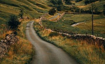
This isolated village is set in idyllic scenery, and is reached along narrow roads with gradients of 1 in 4. The East Lyn is a rocky stream, and if you walk up the valley of the tributary, Badgworthy Water, you will see some of the best of Exmoor. This is popularly assumed to be Doone country, though R D Blackmore, who wrote Lorna Doone, always refused to say where his tale of bandits was actually set.
Blackmore, grandson of a 19th-century rector of Oare, further on from Malmsmead, named his characters after local people. The 500-year-old church here was the setting for Lorna Doone’s violent wedding. At the Robber’s Bridge further along the road there is a picturesque spot by the East Lyn, now only a tiny stream called Oare Water.
Walks near Malmsmead

Malmsmead to Porlock
> Take the unclassified road, then join the A39 to Porlock and eventually on to Selworthy.
Visiting Porlock
Once down the notorious steep hill, and a descent of 1,350 feet (411m), pause to admire Porlock Weir, a small village of thatched cottages fringing a tiny harbour. Culbone Church is possibly the smallest surviving medieval church in England, and can only be reached on foot.
Exmoor Owl and Hawk Centre at Bossington is a must for family outings with flying displays and a wildlife sanctuary. Just off the A39 is Selworthy. Much of this pretty village is owned by the National Trust.
Places to stay in Porlock

Porlock to Luccombe
> Return to the A39 and turn left towards Minehead. Shortly, turn right on an unclassified road to Luccombe.
Visiting Luccombe
Pause in this secluded village to visit the fine church and churchyard, entered through a charming lychgate, and have a gentle stroll past the thatched cottages. At Wootton Courtenay, on the road to Minehead, the magnificent church has a saddleback roof.
Walks near Luccombe

Luccombe to Minehead
> From Wootton Courtenay, turn north to re-join the A39 and continue to Minehead, then further to Dunster, just south of the A39, up the A396.
Visiting Minehead
A large expanse of sand and an attractive harbour area have lured visitors to this bright and breezy town. Take a ride on the West Somerset Railway, which runs through 20 miles (32km) of superb scenery from the coast to the Quantocks. Just outside Minehead is Butlins, a large holiday activity centre with entertainments and a funfair.
A little further on, Dunster’s Norman castle looks out over the village and at the opposite end of the main street is the Conygar Tower, built in 1775 as a landmark for shipping. There is a 16th-century yarn market, and you can see the working water mill, on the River Avill, which dates from 1680 and still produces flour for local bakeries. Blenheim Gardens are fine to sit and relax in.
Places to stay in Minehead

Minehead to Watchet
> Follow the A39, then the B3191 towards Blue Anchor and Watchet.
Visiting Watchet
Much of Watchet’s early growth was due to iron mining in the Brendon Hills; paper-making is now the main industry. The poet Coleridge found the main character for his epic poem The Rime of the Ancient Mariner in this historic seaport.
Just outside Washford, 3 miles (5km) south of Watchet, is Tropiquaria, which has displays of fish and animals. South of Washford is Cleeve Abbey, founded by Cistercian monks in 1198, with a well-preserved refectory, gate house and chapter house. Further along the road is Combe Sydenham Country Park, in a hidden valley on the edge of the Brendons, where there is a restored 11th-century corn mill and a deer park.
Places to stay in Watchet

Watchet to the Brendon Hills
> Take the B3190 and A39 to Washford. Turn left to follow the unclassified road southwards to join the B3188 via Monksilver to Elworthy, then take the B3224 west through the Brendon Hills.
Visiting the Brendon Hills
These undulating slopes, where Exmoor merges into the distinctive patchwork of the Brendon Hills, are not high enough for moorland, but have lush fields and trees and long views across the countryside. In earlier times small mining towns grew up to work the local deposits of iron ore, but the last one closed down in 1883. You can still see Bronze Age round barrows along the Ridgeway.
Walks in the Brendon Hills

Brendon Hills to Winsford
> Continue along the B3224, turn left on the A396 and then follow an unclassified road to Winsford.
Visiting Winsford
Winsford is one of the best centres for tourism on Exmoor, with its church standing over the village. The mysteriously inscribed Caractacus Stone, a mile (1.6km) to the south, probably dates from between the 5th and 7th centuries.
Places to stay in Winsford

Winsford to Simonsbath
> From Winsford take the unclassified road to join the B3223 and continue to Simonsbath.
Visiting Simonsbath
Situated 1,100 feet (335m) above sea-level, Simonsbath is the highest village in Exmoor, in the centre of what used to be the Royal Exmoor Forest. Climb steeply out of the hamlet and on to the moors. In places the traditional old Exmoor hedges block the fabulous views.